The Wreck of Old No. 11

As I write, Thom is on an Amtrak train back home from Oregon for his holiday break. The train, the Coast Starlight, arrived in Eugene early yesterday evening from Seattle, already two and a half hours late. Amtrak’s “schedule” says the southbound Starlight should arrive in Emeryville, just down the track from Berkeley, at 8:10 in the morning. We’re several hours past that. Where’s the train? Still more than a hundred miles away, laboring down the valley somewhere north of Sacramento. Amtrak’s website says the train is now due in at 2:08 p.m., 5 hours and 58 minutes late. That’s a fantasy, since the run got to its last stop 6 hours and 46 minutes overdue.

I don’t mean to beat up on Amtrak (aka the quasi-private National Railroad Passenger Corporation). It’s not news that its long-distance trains can’t keep to a schedule. The Department of Transportation’s fiscal 2004 summary of Amtrak’s performance shows the Coast Starlight makes it to the end of the run when the schedule says it will 22.3 percent of the time. The figure for the Sunset Limited, which operates between Los Angeles and Orlando, is 4.3 percent (4.3 percent! Riding an on-time run on that train would be like winning the lottery). Only the shorter routes, like the Capitols in California, the Hiawathas (Chicago-Milwaukee) and the fast intercity runs on the East Coast have on-time rates higher than 70 percent.

Amtrak doesn’t really try to hide this. Its website cautions that if you’re booking a trip on the Coast Starlight or California Zephyr (Chicago-Emeryville) you might want to “plan for the possibility of delays due to freight traffic, track work “or other operating conditions.” This points to a widely cited Amtrak problem: that it’s treated as a second-class service by the companies that actually own the rails it uses. At the same time, though, Amtrak persists in describing rail travel as a wonder not to be missed. The timetable for the Coast Starlight urges you to “discover one of Amtrak’s most awe-inspiring travel experiences.” Of course, there’s more than one way you can read that.

Another well-known part of the Amtrak story is its perennial deep deficit. The Department of Transportation offers a statistic on each line’s loss per passenger. Generally (and predictably), the shorter, more heavily traveled routes — the ones mentioned above that tend to be on schedule sometimes — show the smallest per-passenger loss. The longer the trip, the bigger the loss and necessary public subsidy. Not that there’s anything wrong with transportation subsidies — we wouldn’t have roads, airports or seaports without them. But if you’re underwriting a $466 per passenger loss (the fiscal 2004 figure for the Sunset Limited; the number for the Coast Starlight is $152), you expect to get a little something in return; a meaningful estimate of when the trains arrive and depart would be a start.

I’ve always loved trains, or at least the idea of trains, and have taken a few long trips starting with my first visit to California from Illinois in 1973. The appeal to me of traveling by rail is pretty much the one Amtrak is trying to sell: You get to see the country close up instead of blasting over it in an aluminum tube. But it’s one thing to support a service that’s basically necessary, or if not necessary, more or less efficient; it’s another to pay for something that’s essentially broken and doesn’t appear to have any prospect for getting better the way things are being run now.

So something’s got to change: Do whatever needs to be done and pay whatever needs to be paid to improve service and make it reliable (fat chance; Amtrak has only grudging support from Congress). Or stop pretending you run the long-distance trains on a schedule: just tell passengers you’re pretty sure you can get them where they’re going eventually and to enjoy the scenery. Or let private operators take the lines and see if there’s any way they can both provide service and make them pay, or at least lose less. Or just let the trains go and shove everyone on to buses and planes.

Road Conditions

In the non-crucial news category, I note after my second California-Oregon-California trip of the last week that the Beaver State (motto: “She drives on her own wheels”) has a kick-ass highway conditions website, Tripcheck. Without returning to my past avocation as rapid web reviewer — hey, I got to help spend $10 million of someone else’s money doing that when the online world was young — I’ll simply say that the interactive maps and webcams and such on the Oregon site make California’s effort look lame (and totally textual).

On the Road Again

Yrekasnow_1

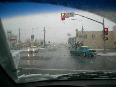
Thom and I drove back to Eugene yesterday, stopped by his dorm, went to dinner (a hippie-style burger enterprise called McMenamin’s), and since it was still fairly early (8:30), I started back south. The weather forecast said a big storm would move in overnight, so I wanted to get over the higher passes along Interstate 5 — especially Siskiyou Mountain Summit, just north of the Oregon-California border — before I stopped. I made it down to Yreka, about 210 miles or so from Eugene and 300 miles from Berkeley, by midnight, then found a motel room. When I got my 8 a.m. wakeup call, I casually looked outside, expecting to see rain. No — snow. I checked online and saw that a winter storm warning was calling for 8 to 12 inches of snow along the route I was traveling. I packed in a hurry, had a cup of Best Western coffee, heard from the desk clerk that chains were required on the highway north but not south, and drove out of the parking lot  at 8:26. This was the scene at Yreka’s traffic light (well, maybe there is more than one).

It snowed pretty heavily off and on for the first 30 miles or so. Then gradually, the snow turned to rain as I descended toward the Sacramento Valley. Drove out from under the storm and got back home just after 1. It finally started raining here in the last hour or so.

Windshield Photography

Shastahighway
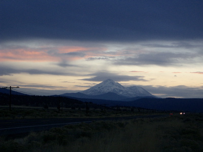
An hour and a half ago, I finished an up-and-back drive to Eugene to pick up Thom for Thanksgiving festivities. On the way to Oregon yesterday, the sun set just as I got to Redding, 200 miles north of here along Interstate 5. Winding through the mountains, Mount Shasta occasionally appears, always bigger than you expect. as you speed up the highway. The mountain, with new snow from the first storms of the season, held the last light long after everything around it was dark.  I tried a through the windshield shot (hey — you have your cellphone, I have my camera) at a low shutter speed; it’s good enough for what it was.

Back South

We were gone 51 hours. Drove 1,035.3 miles. Left Eugene today at 1:51 p.m. and got home (514 miles later) at 10:34 p.m. Stops in Weed, Redding, and Williams. And in Dorris, California, too, to snap a picture of the Elm Motel (see below).

Elmmotel

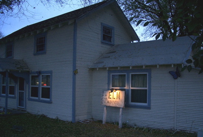
5:03 p.m.: Dorris is the first town you hit in California as you head south from Klamath Falls on U.S. 97. The highway makes several turns in town. This place is just south of the last bend, and just across the street from the big restaurant in town, a divey-looking place called La Tapatia. In addition to these two establishments, Dorris (population in 2000: 886) boasts that it’s the home of the tallest flagpole west of the Mississippi. Whether the claim is true or not (and I can’t find anything right now that contradicts it — stay tuned), the flagpole is an eyecatcher.

Shasta

5:11 p.m.: You could see Mount Shasta for well over 100 miles to the north along U.S. 97 today, despite partial overcast. This is from closer up — it was probably about 45 miles to the northeast of the mountain and just a few miles southwest of Dorris and the warm welcome waiting northbound travelers at the Elm Motel.

Corvette

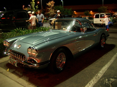
7:13 p.m. At the In-N-Out in Redding. There were two Vettes parked just outside. This was the nicer one and the better picture.

If You Want to Drive on My Road

One thousand miles on the highway (to Eugene and back last week) gives one lots of time to ponder the following: “Why the (your favorite expletive beginning with “f” here) don’t these slow drivers in the left lane get the (favorite expletive again) over?”

Admittedly, such reflections are a necessary product of driving — even preferring to drive — well above the speed limits posted on our Dwight D. Eisenhower System of Interstate and Defense Highways and other fine public routes. I plead guilty. But.

No matter how fast you’re going — the posted speed limit or 15 miles an hour over it — if you look in the rear view mirror and see someone bearing down on you from behind, that tells you they’re going faster than you are and you need to get or stay out of the way. The fact you’re driving whatever speed doesn’t entitle you to the left lane. The sane, courteous and cautious course is to get over to the right at your first opportunity. Let the faster traffic by; presumably that’s what all those “Slower Traffic Keep Right” signs are about.

And also: When you’re going 66 and you decide to daringly overtake that car in front of you that’s going 65, watch what’s happening in the left lane before you pull out to do it. If faster traffic is coming up, either stand on it to make the pass and get it over with so you don’t hold up your sweet-tempered brethren, or wait until the lane clears and you can take your own sweet time (and 12 miles or so) to get past your barely slower neighbor.

Thank you.


Next: The many uses of directional signals.

Williams

Williams1

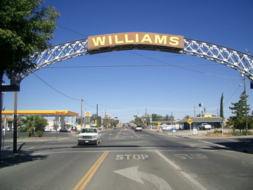
On any drive north or south on Interstate 5, Williams is an important spot on our personal travel map. It’s 100 miles from Berkeley, give or take a mile or two; so when we get there on the way home, we’re within a couple hours of our front door at most; or, headed the other way, we’re about halfway to Redding (or about one-fifth of the way to Eugene).

The town sits on the western side of the Sacramento Valley, where Highway 20 comes down from the Clear Lake plateau and heads across the river bottoms to Colusa, Yuba City, and Marysville  before it begins climbing through the Sierra foothills to Grass Valley and Nevada City.

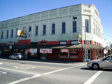
Like all the little farm towns up and down the valley, there’s some history there under the surface, which naturally you don’t get at when you’re just passing through. You sort of suspect it when you look at the handsome old brick building a couple of stop signs west of the interstate with its weathered pale green paint, arcade shading the sidewalk and and recently hung fast-food banners.

The only history I know of, though, is what we’ve seen on our short stops through the years: the ghost Dairy Queen (we walked in one day after the place had been shut down, though all the signs and most of the interior fixtures were intact and the front door had been left open); the crummy road meals; the night we stayed in town with our neighbors, the Martinuccis, and drove out to the fields east of town to watch a comet; stopping for gas on the way home from Wilbur Hot Springs in the blaze of October.

Williams2

Flying Home

Heading back, watching the night unfold, watching the towns approach, slide past,

right-angle layouts, the bright stitching of main streets against invisible landscape.

I can guess the names of the bigger towns: Rockford. DeKalb. Galesburg. Iowa City. Cedar Rapids. All maybes. Nothing big enough to suggest Des Moines or Omaha. Then the smaller towns. Some I’ve passed through, others are just names I’ve picked up along the way. Dyersville. Grinnell. Ottumwa. Story City. Stanhope. Storm Lake. Then across the invisible Missouri: Grand Island. McCook. Hastings. Ogallala.

But most without any names that I know, though I’d love to learn them. All down there somewhere in that thinning web of settlements as we move west, each town throwing its main-drag strands of light into the dark. Island universes in uncounted numbers.

[Translation: United Flight 385, Chicago to Oakland. Took off 8:45 p.m. CDT, landed 10:45 p.m. PDT.]

Anatomy of a Toot

As promised, photographic documentation of what’s called locally “a toot.”

But having spent two hours posting 11 pictures in that little photo album, I’m reminded why I don’t do it more often. I mean, it takes two hours. Part of the problem is the seeming inflexibility of the TypePad photo albums: The pictures appear on your working site in the reverse order you chose them; when you post them, they appear in reverse order again — or, to look at it another way, in the same order you orginally picked them. That always confuses me and I wind up writing absurdly prolix captions (also time consuming) that are supposed to have some sort of narrative order but come out rather jumbled. The current effort’s a case in point. Could be that later I’ll go back in and try to fix my fractured storytelling. But for now: Bed.