
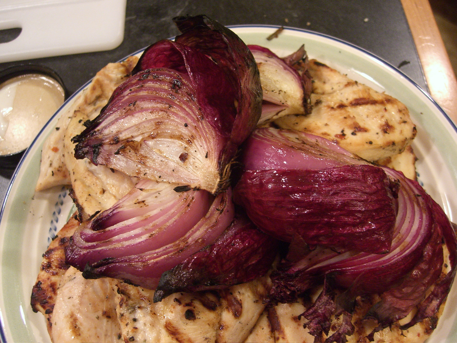
Sunday night at Jan and Christian’s in Hastings-on-Hudson, New York. In our trip across country, Kate and I just once stayed two nights in the same place. So we blew through Jan and Chris’s place, too. But in the afternoon and evening and morning we *were* there, there was lunch at a tacqueria, dessert, a bike ride, a dog walk, a great dinner (above, grilled red onions on a plate with grilled chicken), dessert, a meteor-viewing party (the Perseids, disappointing except for lying down on my back watching the sky, an op-ed published in the Washington Post (Chris’s, on the ongoing threat of lead poisoning), a meeting with a guidance counselor (Jan, at the local high school), breakfast, and that’s about it.
Nice Ride Anyway
A friend asks: Have I been on the bike at all during our trip east? Yeah, I have. But it has been strange. After months of riding hard and getting neurotic about whether I was riding hard enough, now I’m deliberately trying to ride just a little — enough so that when I get to France and this 750-mile ride kicks off, in eight days, I will have maintained the fitness I built up over the spring and summer while not having exhausted myself. (In other words, it’s something else to get neurotic about.) So the riding I’ve done since leaving Berkeley has been a little sporadic and mostly not very intense: half a dozen rides, five states*, only once more than an hour; that’s just enough to remind my legs what they need to do.
Tonight, we’re staying with friends in a little town in Westchester County, on the Hudson just north of New York City. This afternoon, looking for a ride to do, I headed up the South and North County Trailways; they’re paved paths on the right-of-way of an old commuter railroad that used to run up to Putnam County, the next one north of Westchester.
The paths were mostly great,, even though they run close to a couple busy roads most of the 16 or 17 miles north that I rode. The paving was a little rough in places, but there weren’t many other users, the strip of land the path runs along was beautiful, and given how hilly the country is, the route was very flat (that figures, having been a railroad grade).
One thing I discovered is that folks using this trail apparently shun all contact with strangers. I probably passed a couple hundred people in 33 miles — mostly other cyclists, but also a few shaky looking in-line skaters and a handful of runners and very determined-looking walkers. Only one guy I passed acknowledged my wave as I passed; a couple people responded when I told them I was passing them. Mostly I got blank looks — sometimes because people were wearing headphones and listening to iPods, mostly from people who were just disinclined to respond in kind. Strange and oppressive and off-putting, this isolation people take with them out into the world.
Nice ride anyway, though.
*The five states: Nevada, Colorado, Illinois, Pennsylvania, New York.
New York, Pennsylvania
Checking in from Bucks County, Pennsylvania, north of Philadelphia, after stops (briefly) in Allegany State Park, New York, and (longly) in Shiremanstown, Pa., where Kate’s aunt and uncle live. Then today, across the eastern part of the state on the spanking clean pavement of the state’s turnpike (it was such an innovation that when it first opened people used to pull onto the median to picnic). The weather has turned in these parts: We’d had nearly a week straight of heavy, hot, humidity-saturated air; late this afternoon, that gave way to cool, windy weather that reminded me of the Bay Area or perhaps the first hint of post-summer in these parts. We’re staying tonight with Kate’s cousin, then tomorrow will wind up on the northern Jersey shore, where her family lives. Me, I’m just driving, enjoying good food and good company, and starting to obsess about my trip to France next week and whether I’m really ready for it.
Pardon, monsieur. Parlez vous l’anglais?
Wisconsin, Michigan, Ontario, New York

Here’s one issue in the Great North American Mostly Two-Lane Road Tour of 2007®: We finish our travels so late in the day that I’m kind of bushed by the time it comes to accounting for our whereabouts. To back up from today: We got to Tinley Park, in the Chicago suburbs, on Saturday, and spent the weekend in hometown environs. Then yesterday, Tuesday, we drove up to Milwaukee to meet some Berkeley friends who long ago removed to Ripon, Wisconsin (birthplace of the Republican Party and home of a small liberal arts college). In the evening, Kate and I took the new fast catamaran ferry across Lake Michigan to Muskegon, where we crashed in the decidedly oddball Shoreline Inn downtown. Today, we drove across the Lower Peninsula to Lake Huron, virtually all on state highways and back roads. We crossed the Bluewater Bridge from Port Huron, Michgan, to Sarnia, Ontario, experiencing for the first time a no doubt very mild form of the third-degree that travelers across international borders get in our new world (This from the Canadian immigration officer: “Do you have any weapons at home?”); then we drove across most of southwestern Ontario the same way, discovering a nice county-type road that went on forever and stayed close to the Lake Erie shore almost all the way over to Buffalo. After we recrossed the border there, we passed the minor-league ballpark downtown and decided to turn around and go to the game that appeared to be already in progress; the proceedings, between the Buffalo Bisons and the Ottawa Lynx, were already in the fifth inning when we sat down, but the price was right ($3 parking and $7 a seat) and the weather was perfect for a twilight game. The home side lost, and we headed south out of town on U.S. 219, headed for Salamanca and Allegheny State Park. We wound up in a big new chain motel in Ellicottville; tomorrow we’re headed for Harrisburg, Pennsylvania.
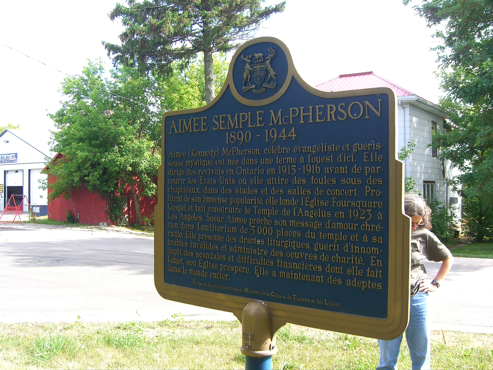
So, that picture up there: Approaching the hamlet of Selford, Ontario, we passed a sign promising a historical marker related to the evangelist Aimee Semple McPherson. I might not have given it a second thought except that Dad has told me that during the year or so he lived with his parents in Pasadena, they took him to see Sister Aimee preach in her Los Angeles temple. She was born in Selford in 1890 and was enough of a personage that her native province saw fit to commemorate her origins. We found two markers, actually: one was a plaque on a flagstone marker in front of the town school; the one above was hidden in some roadside trees; a local saw us wandering around and told us where to look — nice gesture.
In a way, the McPherson sighting was the second related to Dad and his parents today; I remembered as we drove out of Muskegon that they lived there nearly 100 years ago — Sjur Brekke was a Lutheran minister and had a parish somewhere in town sometime around 1910. I’ll get corrected on that if I’m wrong.
Retail Notes from All Over
Worst, most ubiquitous business name: Kum & Go. On the shore of the Pacific, I’ve remained happily ignorant of the far-flung gas-and-mini-mart chain that styles itself Kum & Go. Midcountry dwellers are not so fortunate. These stores were a reliable fixture of just about every little town and off-ramp retail zone starting in Colorado and continuing across Nebraska and Iowa. The Mississippi River apparently has formed a temporary barrier to their spread, as the stores apparently have managed to cross the river only in Minnesota. What’s so objectionable about the name? Well, there’s the moronic simplification and shortening of the perfectly serviceable verb “come.” But the more obvious complaint is the slang connotations of “kum” — yes, usually as “cum” — and the unintentional meaning of the business’s name. Of course, my focusing on the vulgar aspects of the name is just a product of my own filthy obsessions. In the meantime, the company’s doing fine: It’s reportedly No. 267 on the Forbes list of privately held companies, with $1.43 billion in revenue in 2006.
The ol’ general store: Nearly as abundant across small-town mid-America as the lamentable Kum & Gos are the Casey’s General Stores. Though like its Main Street cousin Dollar General, Casey’s seems to have a willingness to aim at small towns that are a bit further off the beaten path than Kum & Go, which has fastened itself lamprey-like to the interstates. That’s my impression, anyway, uncomplicated by any actual analysis of where the stores are. I’ve always liked the homeyness of the chain’s name; Casey sounds like that kindly old merchant of old who’d share out hardware, bulk goods, gossip, and credit in equal measure, with some hard candy thrown in for the young ‘uns. The reality is, and I have the feeling that I may have visited this territory before, is that Casey’s is as down-home as your average 7-Eleven; I haven’t checked on whether the Casey’s stores have those friendly height guides on the entrance doors — a fixture at 7-Eleven — to aid clerks in their description of holdup suspects, but aside from that (and the clean bathrooms on which the company prides itself), you’d probably be hard-pressed to tell the difference. Interesting apparent fact: Both Kum & Go (nearly 400 stores) and Casey’s (about 1,464 outlets) hail from Iowa.
Drugged: Walgreen’s was a familiar name growing up in the Chicago area. I don’t recall that we had one nearby; the Rexall chain and independent druggists owned the market where I grew up. Now, of course, Walgreen’s is everywhere. Berkeley has several of them. On occasion, I’ve stopped in when I happened to be right there and needed something. And it’s odd: No matter what store I’ve gone into, the experience seems the same: Though it’s pretty easy to find what you want, getting out of the store with it is a test of even the hardiest shopper’s stamina. Invariably, you’ll find one or two checkers regardless of the number of people queued up at the registers. If they’re not harried, The checkers seem uniformly despondent. I’m sure the excellent pay and benefits and understanding public are part of the reason they seem so beaten down. The other part has got to be coupon shoppers: You can count on finding yourself behind at least one person who is having some problem either finding a sale item or understanding the difference between what’s really on sale and the stuff they’re trying to buy. This has been the same whether I’m shopping in Berkeley, Chicago, Chico, or the Denver area. I went into a new-looking Walgreen’s today in Evanston, needing a couple things. The store wasn’t crowded, and when I got to the register, there was just one guy in front of me. But he proceeded to get into a protracted discussion with not one but two clerks over the number of packages of toilet paper he could buy for the sale price; after that was worked out, one of the clerks noticed that the pens the guy was trying to buy on sale weren’t really on sale. As the negotiations got to the five-minute mark, a second checker opened a register. But before I could get through, a shopper in that line also entered into an involved coupon transaction. I did get out of there, eventually; I had to write this post.
Road Blog: Driving 80
Conclusion of the foregoing: Lincoln, Nebraska, to Tinley Park, Illinois. (Tinley Park is where my brother Chris and his family live; it’s about 30 miles southwest of the Loop.) Interstate 80 all the way, about 515 miles, and I’ll only say that that stretch of road does nothing to sweeten your correspondent’s disposition despite the gorgeous green rolling Iowa and Illinois countryside. It makes me wonder whether we ought to try do the rest of the drive out to New York on two-lane roads.
Technorati Tags: illinois, iowa, interstate 80, travel
Road Blog: Wagon Train
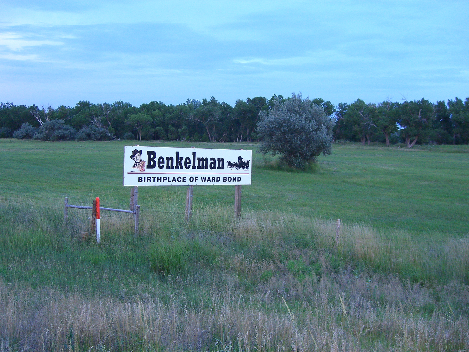
A long day, from Craig, Colorado, to Lincoln, Nebraska. Long by my 2007 standards, anyway. Something like 700 miles, through Rocky Mountain National Park and then blasting across the Plains. Many sightings. Here’s one, from Benkelman, Nebraska. Somewhere, Mary Alice Brekke is smiling that one of her offspring crossed paths with the beloved Ward Bond.
Road Blog: Tiny Ass Ranch

Day Two of the Great ’07 Road Trip and Fuel Profligacy Expedition®: Wendover, Utah, to Craig, Colorado. We drove somewhere between 450 and 500 miles today on Interstate 80 (first 120 or so) and U.S. 40 (the rest).
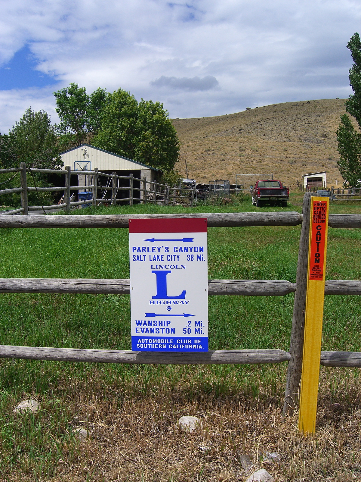
U.S. 40 in Utah and Colorado, like U.S. 50 in central Nevada, lays claim to lying along the route of the original Lincoln Highway; there are signs along the way reminding you. Due to a missed exit — I was preoccupied enough by traffic out of Salt Lake City that I never saw the huge, obvious signs for U.S. 40 — we wound up driving through Wanship, Utah. One of the bonuses was the Lincoln Highway marker below, which carries the name of the Automobile Club of Southern California. The oddity is that it’s on a dead-end stretch of road just outside Wanship, which looks to be a town of about 200 people with an I-80 on-ramp.
The bigger bonus was the sign above. Kate spotted it as I was looking for a turn. We backtracked, then went two blocks west, as the sign suggests, to find the Tiny Ass Ranch. We found a trailer and mailbox with that name emblazoned upon them, but no obvious ranch or roundups in progress. A guy shoveling manure in a barn nearby called, “Can I help you?” when he saw me with my camera. I asked him what the story was with the Tiny Ass Ranch. “Oh — he raises little donkeys.”
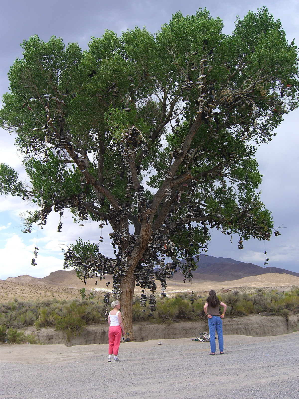
Road Blog: Shoe Tree

On U.S. 50, between Fallon and Austin, Nevada. I noticed a couple cars pulled off the north side of the road; and then I saw why. Thousands of shoes hanging in a big cottonwood. Mostly running and gym-type shoes. A few pairs of work boots. At least one pair of cowboy boots. They’re hung from some of the highest branches, so a lot of climbing goes into this project.
We stopped. There was a couple in an older minivan headed west and a woman in a sedan with New Mexico plates. I asked whether anyone knew the story behind the shoes. The couple shrugged. The New Mexico woman said, “I do.” The legend, as she called it, is that a newlywed couple had a fight and flung their shoes into the tree. “Where did you hear the legend?” I asked. “I’m a tourist,” she said — on her way back to New Mexico after a month on the road. “I found the story in a brochure back in Fernley — this passport thing I got.”
The passport thing turned out to be “The Official Hwy. 50 Survival Guide: The Loneliest Road in America,” a production of the Nevada Commission on Tourism. The guide is an attempt to turn lonely U.S. 50 into a tourist route; you can get a copy at stores along the route, and collect stamps at each of the major towns along U.S. 50’s “loneliest” stretch: from west to east, Fernley, Fallon, Austin, Eureka, and Ely. Kate got one in Austin, and we stopped throughout the afternoon and early evening getting it stamped. Now she can send in a postcard from the guide and get a lovely parting gift from the state tourist people.
Unusual day along 50, by the way: It rained about halfway across the state; at one stop, Cold Springs, the bar/restaurant/motel/RV park proprietor said it was the first rain in four months. And further east, we encountered a road crew cleaning up rock slides on a canyon section of the highway. We wound up in Wendover, Utah, a couple blocks east of the Nevada state line (and a couple blocks into Mountain Time). Left Berkeley at 9:30 this morning, got here at 10:30 (our time). Rain notwithstanding, we drove 650 miles in those 13 hours.
Gone Riding
My apologies to you noble few who visit every once in a while for my neglect the past few days. Explanation: I was out riding my bike over the weekend and absorbed in planning for that when I wasn’t actually in the saddle.
The brief details: Two days, 317 miles. From Berkeley, on the bay shore, to Chico, on the eastern edge of the upper Sacramento Valley; and then from Chico to Davis to catch a train home. It was hot — temperatures mostly 95 or a little below but up to 98 at a couple points and with plenty of extra heat coming off the roads. Rode with my friend Bruce and another Paris-Brest-Paris-bound cyclist, Keith, and Kate met us a couple times along the way Saturday to make sure we weren’t suffering from anything more serious than cycling-related dementia. Saw an abundance of big, striking birds as we rode past the rice fields planted along the general course of the Sacramento: great egrets, snowy egrets, great blue herons, hawks of all descriptions, a (possible) juvenile bald eagle and a new one for me, the black-necked stilt.
More later. Really!
Technorati Tags: california, cycling, pbp, randonneuring