‘A Ruin, Only in Reverse’

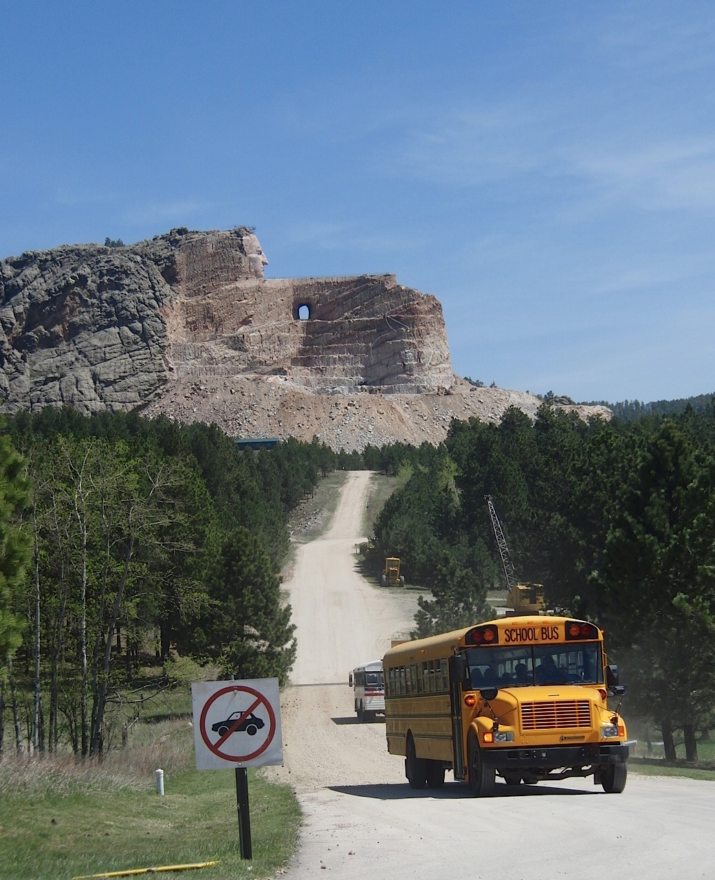
The Ziolkowski monument to Crazy Horse in South Dakota’s Black Hills.

Last June, I drove from Seattle to Omaha with my son Eamon and my daughter-in-law Sakura. Our first day took us into western Montana. The second day saw us get to western South Dakota after a stop at the Little Big Horn. And the third day we started out with a quick blast through the Black Hills. We stopped in Deadwood, then headed to the Crazy Horse monument. That’s the picture above. If you pay a little extra when you visit the memorial, you can take a bus ride right up close to where the work on the monument is going on.

I had been to Crazy Horse once before, back in 1988, with my dad, when we were on our way to the Little Big Horn. Back then, you had to take the artists’ word that something would emerge from the mountain they were blasting away. At the visitors center, we paid a dollar for a chunk of granite from the rubble, faced with mica and shot through with what look like nodules of pyrite. The rock’s here on the dining room table as I write this. Twenty-three years later, something dramatic has been brought out of the mountain, and the scene around the area has changed, too. The site is now approached on a route that’s turned into a major highway, and the turnoff is controlled by the kind of traffic signal you see on expressways in San Jose. There’s an entrance plaza with maybe six lanes, just like going into a stadium parking lot. After that, there’s plenty of parking, a museum, shops, and beyond that, the mountain. Lots of people were visiting the early June day we stopped, though I wouldn’t say the place was overrun.

A few days ago, I came across Ian Frazier’s account of his visit to Crazy Horse, probably within a year or so of when we were there. Here’s what he saw, as recounted in his book “Great Plains“:

“In the Black Hills, near the town of Custer, South Dakota, sculptors are carving a statue of Crazy Horse from a six-hundred-foot-high mountain of granite. The rock, called Thunderhead Mountain, is near Mt. Rushmore. The man who began the statue was a Boston-born sculptor named Korczak Ziolkowski, and he became inspired to the work after receiving a letter from Henry Standing Bear, a Sioux chief, in 1939. Standing Bear asked Ziolkowski if he would be interested in carving a memorial to Crazy Horse as a way of honoring heroes of the Indian people. The idea so appealed to Ziolkowski that he decided to make the largest statue in the world: Crazy Horse, on horseback, with his left arm outstretched and pointing. From Crazy Horse’s shoulder to the tip of his index finger would be 263 feet. A forty-four-foot stone feather would rise above his head. Ziolkowski worked on the statue from 1947 until his death in 1982. As the project progressed, he added an Indian museum and a university and medical school for Indians to his plans for the grounds around the statue. Since his death, his wife and children have carried on the work.

“The Black Hills, sacred to generations of Sioux and Cheyenne, are now filled with T-shirt stores, reptile gardens, talking wood carvings, wax museums, gravity mystery areas (‘See and feel COSMOS–the only gravity mystery area that is family approved’), etc. Before I went there, I thought the Crazy Horse monument would be just another attraction. But it is wonderful. In all his years of blasting, bulldozing, and chipping, Ziolkowski removed over eight million tons of rock. You can just begin to tell. There is an outline of the planned sculpture on the mountain, and parts of the arm and the rider’s head are beginning to emerge. The rest of the figure still waits within Thunderhead Mountain–Ziolkowski’s descendants will doubtless be working away in the year 2150. This makes the statue in its present state an unusual attraction, one which draws a million visitors annually: it is a ruin, only in reverse. Instead of looking at it and imagining what it used to be, people stand at the observation deck and say, ‘Boy, that’s really going to be great someday.’ The gift shop is extensive and prosperous, buses with ‘Crazy Horse’ in the destination window bring tourists from nearby Rapid City; Indian chants play on speakers in the Indian museum; Boy Scouts, Girl Scouts, local residents, and American Indians get in free. The Crazy Horse monument is the one place on the plains where I saw lots of Indians smiling.”

If you happen to go to the monument in the fall, there’s a walk to Korczak Ziokowski’s tomb every year on October 20, the anniversary of his death. Also interred there: his daughter Anne, who died last year just a few week’s before we visited. Her obituary, brief as it is, speaks volumes about the family’s commitment to the Black Hills.
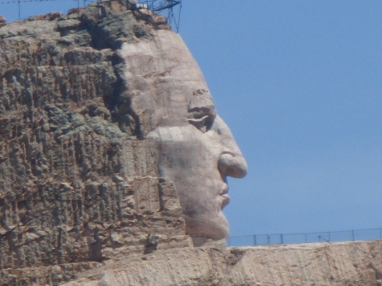
Black Hills Crazy Horse monument in closeup.

On Tenaya Lake

icewhisperer.jpg

The vanity never stops. This is me out on Tenaya Lake in Yosemite the week before last. My nephew Max snapped the picture and titled it “The Ice Whisperer.” What I was after was the sound–a lot like the sound of whale calls–emanating from the lake as the ice expanded and reacted to the strollers and skaters on the surface. You can get a vague idea of the sound, in between passages of me crunching around on the ice, from the audio clip below. Note: I was the only one in shorts out there, prompting one person to say, “I hate you. But thank you, because I think that’s going to make it snow.” The lake is under a couple of feet of snow right now after a series of storms that started last Thursday.

Tenayalake.mp3 by Dan Brekke

Journal of Self-Promotion: ‘Roof of California’

I have a sense of when I’ve stayed on one topic too long, and this is one of those times. But bear with my carrying on about Tioga Pass just a few minutes longer. As mentioned (and pictured) earlier (and then mentioned again, elsewhere), I drove up across the pass last week on a blitz-style Yosemite tour with my nephew Max. I also brought a sound recorder along and wound up talking to people we met along the way, and that led to a radio story that aired Thursday morning on KQED’s “The California Report.”. Oddly, because of a problem with the The California Report site, the link to our airing of the story is still acting weird for me. story. But the piece also aired on KPCC in Los Angeles, and here’s the link to the story as it played there:

Clear skies in the Sierra Nevada open up access to Yosemite.

OK–that is it for now. Until I get the picture that Max shot of me walking around wearing shorts on the frozen lake.

High Country, Out of Character

mountdana011112.jpg

That’s Mount Dana, elevation 13,057 feet above sea level, just south of Tioga Pass in Yosemite National Park. The picture was shot from a ridge above the Gaylor Lakes just north of the pass, elevation about 10,500.

My nephew Max and I drove across the Tioga road on Wednesday, and it’s a trip that will leave an impression for some time. As I’ve said elsewhere, this is country that’s normally far beyond the reach of the casual winter traveler. The Sierra this high up is usually buried in snow. Beyond that, it can be cold and harsh in a way that’s utterly foreign to us Northern California lowlanders. The day we were up there, it felt like the temperature was in the high 40s, at least, and warmer in the sunlight. There was no wind. I was wearing shorts, though that was pushing it a little. Plenty of others have journeyed up to this strangely accessible alpine world. A local outdoors writer did a blog post last week about a couple guys who had driven up to hike Mount Dana–yeah, that peak pictured above–in running shoes.

All the weather forecasts show that this midwinter idyll, made possible by a long, long dry spell accompanied by unusually mild daytime temperatures, is coming to an end. The forecast for the end of the week is blizzardy: snow, then more snow, with high winds. And already, the weather has changed. Today’s high is for a high of about 30, with 50 mph winds gusting to 80 mph. Tonight’s forecast: a low of 10, with a westerly wind of 60-65 mph gusting to 105 mph. I have a picture in my head of being blown clear off this ridge.

More on this later. For a rather short trip–we were only on the road across the high country for a few hours–it filled my head with impressions.

Bolinas Ridge Bovine Encounter

bolinasridge010812.jpg

Today’s outing: To the Bolinas Ridge Trail in West Marin. We got out there to the north end of the trail, at Sir Francis Drake Boulevard, probably an hour, an hour and a half before the sank behind Inverness Ridge, to the west. We found a sort of rocky natural platform overlooking a ravine and the trail we had walked in on, and just stayed there as the sun went down. Soon, the moon rose, and we walked back to the car. This lad (or lass–my non-farm eye didn’t see evidence one way or the other) was one of the many bovines along the trail. Nice place to be a cow, or a bull, or whatever.

Vulture Beach Drama

vultures120311.jpg

Saturday in Fort Bragg: Just north of the mouth of Pudding Creek, a couple of dozen turkey vultures were hanging out around a low bluff above the beach–sunning themselves, taking off on short flights to check out the local offal, then back for more sunning, and grooming, and occasional dramatic wing spreading and beaking (if “beaking” is what you call it when two birds go beak-to-beak).

vultures120311c.jpg

Motel View

fortbragg120411.jpg

A discovery of 2011, by way of Thom Brekke: The Beachcomber, a motel in Fort Bragg. Here’s what you see right out the back of the place, which is built adjacent to an old logging road (and before that, a rail line) used to carry logs to the Fort Bragg mills. The mills are gone, but the road persists as a trail that runs from the motel, on the north bank of Pudding Creek, for seven miles or so up the coast. Along the way, there’s lots of beach and bluff frontage. It’s an amazing place, really.

Road Blog: Mendocino Vineyard

toulouse120411.jpg

Back home in Berkeley tonight. But at noontime today, we stopped on our way south at Toulouse, a vineyard and winery along Highway 128 in Mendocino County. We went into the tasting room and bought some wine, then walked up through the vineyards briefly. One bird note: We see robins down here, of course. They’re everywhere, right? But up at Toulouse today, their presence was a little more than we see around the city. hundreds if not thousands of robins filled trees around the harvested vineyards. Checking one Mendocino birding site, the county seems to be a major wintering locale for American robins (Turdus migratorius; yes, “Turdus”; it’s Latin for “thrush”; you know there’s a whole story about why it’s called “robin,” but some of us can’t stay up all night to tell it).

A general explanation for the robin swarm around the vineyards comes from Cornell’s Birds of North America: “The diet of the robin is … highly variable, changing from primarily soft invertebrates, especially earthworms, in spring and summer, to primarily fruit in autumn and winter. During the nonbreeding season, large flocks of hundreds or thousands of immature and adult birds migrate to lower elevations and latitudes, where they form roosting aggregations from which they track sources of berries.” Cornell also notes that the robin is a relatively recent arrival in much of California west of the Sierra foothills, not pushing into other parts of the state until irrigation and well-watered lawns (and thus a richer supply of earthworms near the surface) made it possible for the bird to extend its range. And one more note from that Mendocino County site: robins (and some other abundant songbirds) are favored prey of some raptors (peregrine falcons and sharp-shinned hawks, among others).

The sound of the birds near the vineyard was remarkable enough I recorded some audio and will try to post that later.

Road Blog: Mendocino Vineyard

toulouse120411.jpg

Back home in Berkeley tonight. But at noontime today, we stopped on our way south at Toulouse, a vineyard and winery along Highway 128 in Mendocino County. We went into the tasting room and bought some wine, then walked up through the vineyards briefly. One bird note: We see robins down here, of course. They’re everywhere, right? But up at Toulouse today, their presence was a little more than we see around the city. hundreds if not thousands of robins filled trees around the harvested vineyards. Checking one Mendocino birding site, the county seems to be a major wintering locale for American robins (Turdus migratorius; yes, “Turdus”; it’s Latin for “thrush”; you know there’s a whole story about why it’s called “robin,” but some of us can’t stay up all night to tell it).

A general explanation for the robin swarm around the vineyards comes from Cornell’s Birds of North America: “The diet of the robin is … highly variable, changing from primarily soft invertebrates, especially earthworms, in spring and summer, to primarily fruit in autumn and winter. During the nonbreeding season, large flocks of hundreds or thousands of immature and adult birds migrate to lower elevations and latitudes, where they form roosting aggregations from which they track sources of berries.” Cornell also notes that the robin is a relatively recent arrival in much of California west of the Sierra foothills, not pushing into other parts of the state until irrigation and well-watered lawns (and thus a richer supply of earthworms near the surface) made it possible for the bird to extend its range. And one more note from that Mendocino County site: robins (and some other abundant songbirds) are favored prey of some raptors (peregrine falcons and sharp-shinned hawks, among others).

The sound of the birds near the vineyard was remarkable enough I recorded some audio and will try to post that later.

Road Blog: Fort Bragg Xmas Extravaganza

fortbraggparade120311.jpg

We drove up to Fort Bragg with a plan of driving someplace in the interior of the county–Montgomery Redwoods State Reserve, near Comptche in the back of beyond, was one candidate. But in the full light of day and looking out at the coast right outside our window, it seemed to make a lot more sense to just hang here. So we went for a long walk up a coastal trail to MacKerricher State Park north of town, then back. The Dog, for one, was delighted. Then we went and had a bowl of clam chowder down by the Noyo River harbor. We started back to town, then Kate remembered a plaque about the local salmon fishery she wanted to show me. The plaque was on the outside wall of a restaurant at the harbor. When we pulled into the parking lot, there was a pickup truck parked there towing a dory festooned with Christmas lights. A woman wearing a Santa hat was standing next to it. “Making your rounds?” I said. “Yeah, I start early,” she said. Then she told me that the boat was decked out for the town’s annual Christmas parade, starring local working vehicles like logging trucks and yes, a few boats. “Seven o’clock. You should come out. It’s a big deal for our little town,” she said, adding that it has been going on for something like 75 years. So after going back to our room, taking a nap, watching part of the Wisconsin-Michigan State game, we walked across the pedestrian trestle from our motel into town and found the parade. The vessel pictured (at the corner of North Main Street and East Redwood Avenue) is the one we saw down by the harbor.