Twelve years ago this month, our lives changed in a way we never saw coming: A dog found Kate in the California outback and adopted her, and us.
By way of explanation: We were down in Paso Robles, at the southern end of the Salinas Valley, for a long Saturday bike ride I was doing. While I was pedaling all over hell and gone with my friend Bruce Berg, Kate went off for the day with Bruce’s wife, Linda Artel, and some of her friends for a visit to the Carrizo Plain.
For the purposes of the present tale, the main thing to know about the Carrizo Plain is that it’s not close to anything. It lies in the lee of the coastal ranges to the west, and you need to cross a mountain range to the east to get to the dry southern end of the Central Valley. From Soda Lake, the alkali mudflat at the heart of the plain, it’s a long, dry trip to anyplace where people live.
So Kate’s group got a surprise as they joined a ranger’s tour on that clear, hot Saturday. Strolling along a plank walk on the edge of the lake, a boy in the group called out, “There’s a dead dog.” A dog’s tail was sticking out from beneath the walkway. When the ranger climbed down to investigate, the tail began wagging — its owner wasn’t dead after all.
In fact, there were two dogs that had sought shelter in the meager shade afforded by the walkway. The one with the wagging tail emerged immediately, covered in gray mud — the boy who had spotted him called him “Dusty.” The other dog refused to come out — maybe too scared or too exhausted to respond to the ranger’s coaxing.
But “Dusty” went with the group back to the ranger’s truck. The ranger tied a rope to the dog’s collar, and Kate, with the group’s encouragement, took charge of him. He drank some water and ate a little turkey from someone’s sandwich. When the group got to its next stop, a trail leading to some Native American pictographs, Kate stayed with the dog, whose coat was beginning to show through as the mud and dirt covering him began to fall away. He looked like he was actually black, with a white chest — a border collie, maybe — and Kate was taken with him.
The feeling was mutual. When Kate left “Dusty” with Linda so she could go off and see the pictographs herself, the dog stared after her and didn’t relax his attention until she returned.
The ranger had said at some point that he would have to drive the dog to an animal shelter in San Luis Obispo, about 70 road miles away. Kate wrote down her contact information and told him she’d be interested in the dog if no one claimed him.
“You know, you can take this dog now if you want him,” the ranger said, adding it was very unlikely that anyone would come looking for him. That was because the dog probably was not lost but had been abandoned on the desolate plain.
Kate was reluctant at first. She hadn’t talked to me, for one thing, and we were staying in a motel that didn’t allow pets. But Linda and the other people in the group urged her to take the dog and even said they’d keep it for her overnight if necessary. So she agreed to take the dog, who was alert and friendly but still so weak that Kate had to lift him into the back of our van.
When she got back to Paso Robles, she set about taking care of business. She went to one of those big-box pet stores, where she hoped to give the dog a bath. But since it wasn’t clear he’d had his shots, the store wouldn’t allow it. So she bought pet shampoo, a big towel, a bed, food and other supplies and brought the dog back to our motel. A woman at the front desk said not to worry about having the dog in our room as long as he didn’t make a racket. “Try to keep a low profile,” she said. Kate bathed him — it turned out he had white paws — and afterward the dog fell asleep.
Remember that I was out there somewhere on my bike all this time and had no idea any of this was going on. Thinking back, I’m remembering the last leg of the ride, through the hills south and east of Paso Robles, and making my way back to town a little after dark, alone. I got to the finish area in the town square and thought I’d see Kate, who I figured would want to share my triumph. But she was nowhere to be found, and she didn’t answer when I tried to call her cellphone.
I may have been peeved. I went back to the motel, just a block or so away, and wheeled my bike toward our room. The window was open.
“Kate?” I called. There was a pause. Then she said, “Wait a minute — there’s a … a … a being here.” She didn’t want to say “dog” in case someone heard her.
I’m not sure I said, “Being?!?” out loud, but that’s what I was thinking. When I opened the door, I saw what — who — she was talking about.
Kate’s recollection is that my first words were, “So we have a dog now?” All I remember was that the dog was quiet and put up his paw to shake when I approached. And yeah, he was a good-looking hound, too.
That night, Kate said she wanted to give the dog a classic dog name, something short. One syllable.
My first suggestion: “Richard Milhous Nixon?” I wasn’t serious — why would you do that to an innocent pet? — but I actually like the idea of naming a dog “Nixon” for its sheer improbability.
“No,” Kate said.
“How about ‘Scout,'” I said.
And that stuck immediately.
The next morning, Scout had recovered to the extent that when we went to get in the van to drive back north, he jumped in the back by himself. When we stopped at a Starbucks on the way home and Kate went inside, he stood guard at the door until she came back out. She was already, and would always be, his pack leader.
Back in Berkeley, we did what you do with a newly adopted pet found wandering in the backlands. He was skinny and full of worms, ticks and foxtails, and we took him to the humane society for a checkup. The vet pronounced him basically healthy. “He’s a good dog — a really good dog,” the vet said. Maybe a year and a half old.
But he pointed out a couple of things that he thought were odd: the little incisor teeth in his lower jaw were badly worn, as if he’d been chewing something hard, like rocks or maybe a chain. Also, he had a recent-looking incision that showed he had been neutered.
What was the story there? Had he been tied up for a long time somewhere and worn his teeth down chewing on things? Had he been in a shelter where he’d been fixed as part of an adoption process? He hadn’t been microchipped, so there was no history to go on.
We always wondered how he had wound up in the back of beyond. Maybe a week after we brought him home, I called down to the visitors’ center at the Carrizo Plain National Monument to see if anyone had reported a lost dog. As I recorded at the time:
“No,” the woman at the center said, “and let me tell you what happens with these dogs. People come out here and just leave them, no water, no food, nothing. It’s a real bad deal.” Occasionally, she said, herders will shoot the strays to keep them from harassing sheep grazing in the area. Starvation or thirst or coyotes take care of most of the rest, though occasionally the monument’s rangers will catch a dog and take it to the animal shelter in San Luis Obispo.
“This is far enough off the road that you can put the dog out and drive away and they can’t chase you,” the visitors’ center woman said. “People split up and decide they can’t keep their dog, or they don’t want to take it to the shelter — over in Taft you just put the dog down a chute and they usually just put it to sleep. But this is a bad deal. You wonder what people are thinking.”
The mystery only deepened over the ensuing months and years. Scout was sweet-tempered, well-behaved, and very quick to learn. He was already house-broken. He didn’t go nuts and chew things up when we were out of the house. It took me all of a week or so to teach him what I wanted him to do — top priority: stop at corners and not go into the street — when I walked him off leash.
He was opinionated, letting us know where he wanted to go and what turns we ought to make when we were out on walks. He remembered the routes to the stores and cafes around town that were reliable sources of treats and tried to get us to visit them often.
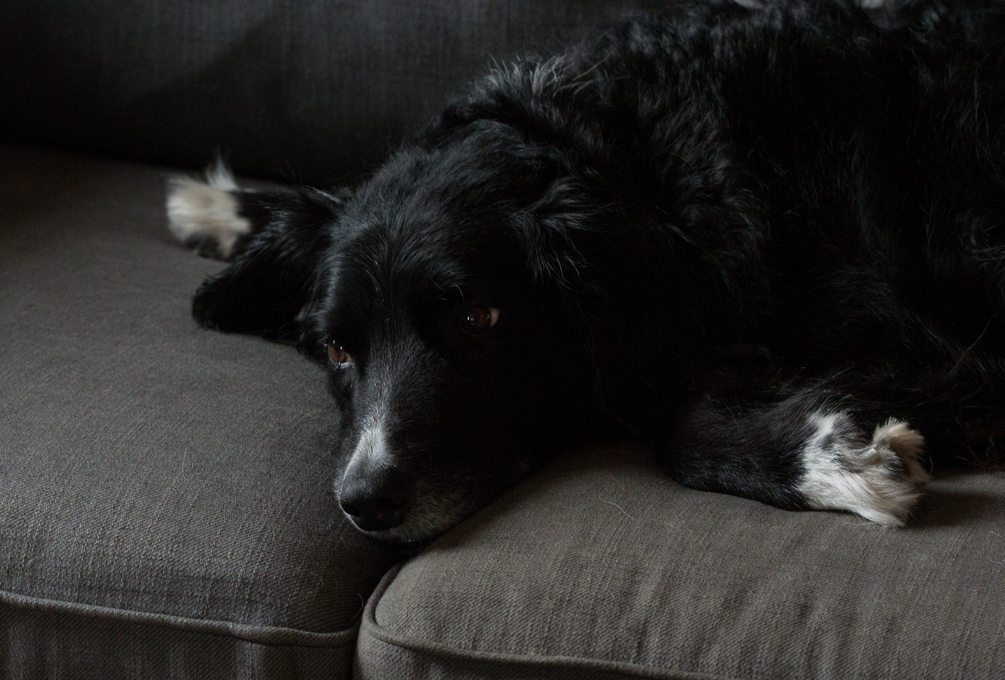
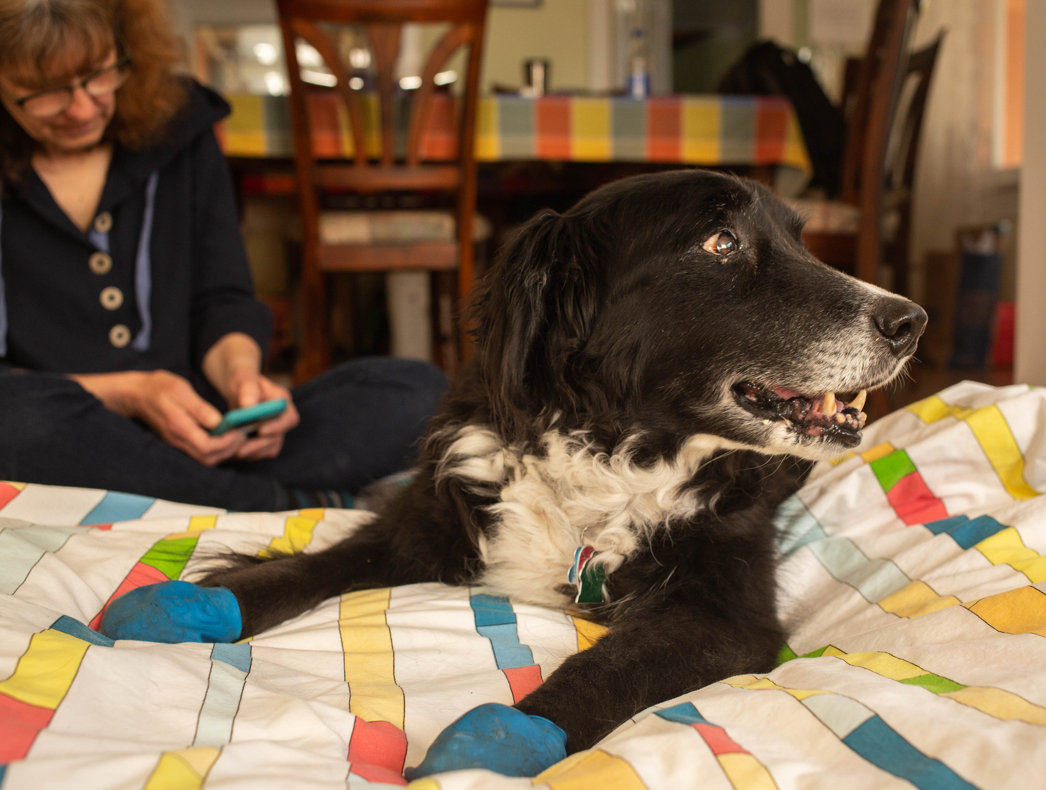
He was bright-eyed and handsome to a fare-thee-well, and strangers often commented on how good looking he (or, as they often thought, she) was. He was patient, attentive, loyal, goofy and funny. He put up with long car trips. He loved to be outside and walk and walk and walk. He was good with kids and other dogs and even the backyard chickens.
He left an impression on the neighborhood and on us — on people who would see him and greet him regularly, and on us as we traveled nearby blocks. “Scout’s choice” meant a walk where we’d follow his turns. “Fancy crossing” was a diagonal crossing at an intersection. “Boring way” was our walking route through the neighborhood on our routine walk before bed; “interesting way” was an alternate route through the little shopping district nearby. “Through the grotto” was a shortened nighttime walk. Past “head grabber” was the route past a nasty rose bush growing low over the sidewalk.
To be fair and balanced, he had a few drawbacks: He was a little slow to learn what skunks were about and took a couple of direct hits in the face. He was a cadge, and especially in his bad-breath old age had a terrible habit of sitting next to us when we ate pizza and panting in expectation of the crusts he was sure would come his way. He was a fiend for any discarded food item, regardless of provenance, age or wrapping, that he sniffed out on the streets, sidewalks, lawns and shrubbery along our walks; I don’t doubt that I occasionally left strangers with the impression his name was “Goddamnitscout.”
Kate has always pointed out that whatever had happened to Scout before he was discovered on the edge of the dry lakebed, he was an optimist by nature, a trusting soul, and smart enough to weigh the odds of survival. When people had happened across his little shelter, a place where he could well have died if help didn’t arrive, he ventured out to greet them, tail wagging.
In short, he was amazing, and an amazing find to make out there in the wild. For years, right up to this week, I wished Scout could tell us what or who brought him there, what his name was before Kate found him.
One thought I had over the years about his apparent abandonment: Maybe he was put out on his own because whoever had him before didn’t think he was fit to be a working dog. He had a border collie’s smarts mixed with some other breed’s reserve and calm. When he was young, he was energetic and fast and loved to run — herding other dogs and leading the neighborhood greyhound, Porter, on intense but inevitably short chases. He didn’t show signs of discomfort. But a neighbor, Alice, who became one of his best friends, observed the first time she saw him walk that it looked like he had hip dysplasia.
That was never a formal diagnosis, but it became apparent as he aged that Scout was big and strong in his front end and rather stiff and weak in his back end. He compensated. We went on long, long walks from our place up into the hills and back, and he never shrank from long flights of stairs or steep trails or any other stupid thing I asked him to undertake.
That changed, though, and in the last couple of years, that trend became much more pronounced. He stopped wanting to go on the longer walks. The weakness in his hindquarters became more evident, and he could no longer raise his tail, let alone wag it. He was done with stairs, except for the descending variety. He slowed way down and sometimes dragged his back legs to the point where you could hear his back claws scratching on the sidewalk. What might have once been a 10- or 15-minute walk took a half-hour, then longer. He began panting loudly even making what seemed to me to be a mild effort. He became incontinent and for the first time started leaving dumps on the floor with enough regularity that we’d have to remind ourselves to watch for them if we got up in the middle of the night. On top of all that, he seemed to have gone nearly totally deaf and his eyesight seemed to be failing.
But he was still himself, sweet and most content, we thought, just hanging out with us. And he was as focused as ever on his pack leader, following Kate around the house, monitoring her comings and goings.
Over the past six months or so, we had started to talk about whether, or when, we might need to do something. By “doing something,” I mean “put him to sleep.”
It was a strange and fraught conversation for both of us.
Strange, for me, because even though I grew up with many dogs — Pooh Bear, Flag, Lizzie, Chip-Chip, Dulcey (short for Dulcinea — our mom being a fan of “Man of La Mancha”), Posey and Angus, among others — putting them to sleep had never really been a consideration. Nature or high-speed traffic intervened to shorten the lives of virtually all of them. For instance: Pooh Bear, our first dog, a beautiful springer spaniel mix, lay down and died at Mom’s feet after her treatment for heartworm.
And fraught, obviously, because here we were, Scout’s people, pondering ending a life that he couldn’t tell us he was enjoying or not. We wanted to do the best we could by this noble, dear creature and do it with the understanding that we were on our own in making it.
One thing Kate and I agreed on was that we didn’t want to see Scout reduced to a state of utter helplessness or to be in a situation that required some sort of emergency response. The week before last, we got a chance to see what “utter helplessness” might look like. For most of a day, Scout was unable to stand up without help and could only walk with some difficulty. So we decided to act.
Vets here in Berkeley — and probably many places — will make house calls for those who have decided to put their pets to sleep. It’s a way of avoiding the stress of bringing a sick or dying pet into the clinic for an inevitably traumatic procedure, and perhaps a way of taking some comfort in the last moments of a companion.
Our appointed time was late last Monday afternoon.
Having worked over the previous weekend, I stayed at home to get things ready. I vacuumed and mopped and cleaned up a little — why exactly I can’t tell you — and I took Scout out for our last walk together.
My grief had crystallized around two thoughts: First, that what we were about to do was final — very final, with no turning back. And second — and most painful for someone who has always experienced a pang of sorrow at endings — that this chapter in our lives, the Scout chapter, the story of being alongside this being, as Kate had called him so long ago, was about to be over.
Beyond that was the fact Scout was such a presence — and a reliably cheerful one — in our lives. Even shuffling along in the way he was reduced to doing in his last few months, he seemed to relish being out with his pack.
The afternoon arrived. Thom came over, and Kate got home about an hour before the vet was scheduled to arrive. We spent the late afternoon sitting with the dog, and Kate read something she had written:
“Twelve years ago, when you joined our family, you had only a collar, and your whole wonderful self. We called you Scout, and you always liked to lead us. We can’t follow you now, but our love and thanks follow you and stay with you. Good dog, Scout. You have always been a good dog.”
The vet and her technician got here a few minutes late — I was glad for even that little extra time. They set up for their procedure: They’d give Scout a strong sedative that would calm him after a few minutes, then an overdose of an anesthetic that would stop his heart.
The dog was a little agitated. He knew something was up — all these people hanging around all of a sudden, and maybe he picked up the scent of the veterinary hospital, too. But we calmed him. The drugs were administered, and he was gone. The vet and technician bundled him onto a litter, carried him out to their station wagon, and departed.
And now? Well, Scout is still here in lots of ways, but most in our expectation that he’ll be waiting for us when we open the front door or eager to go out for his morning walk. That will pass, I guess. Eventually.