A random radio mention of Tewksbury, Massachusetts, and its connection to the story of Annie Sullivan, celebrated as “The Miracle Worker” for her role in the education of Helen Keller and the blind and deaf in general, leads me here:
“The essence of poverty, is shame. Shame to have been overwhelmed by ugliness, shame to be the hole in the perfect pattern of the universe. In that moment an intense realization of the ugliness of my appearance seized me. I knew that the calico dress which I had thought rather pretty when they put it on me was the cause of the woman’s pity, and I was glad that she could not see the only other garment I had on … the inadequacy of my outfit did not dawn upon me until the woman pitied me.”
(I wound up reading the entire AFB “gallery” on Annie Sullivan. What a story.)
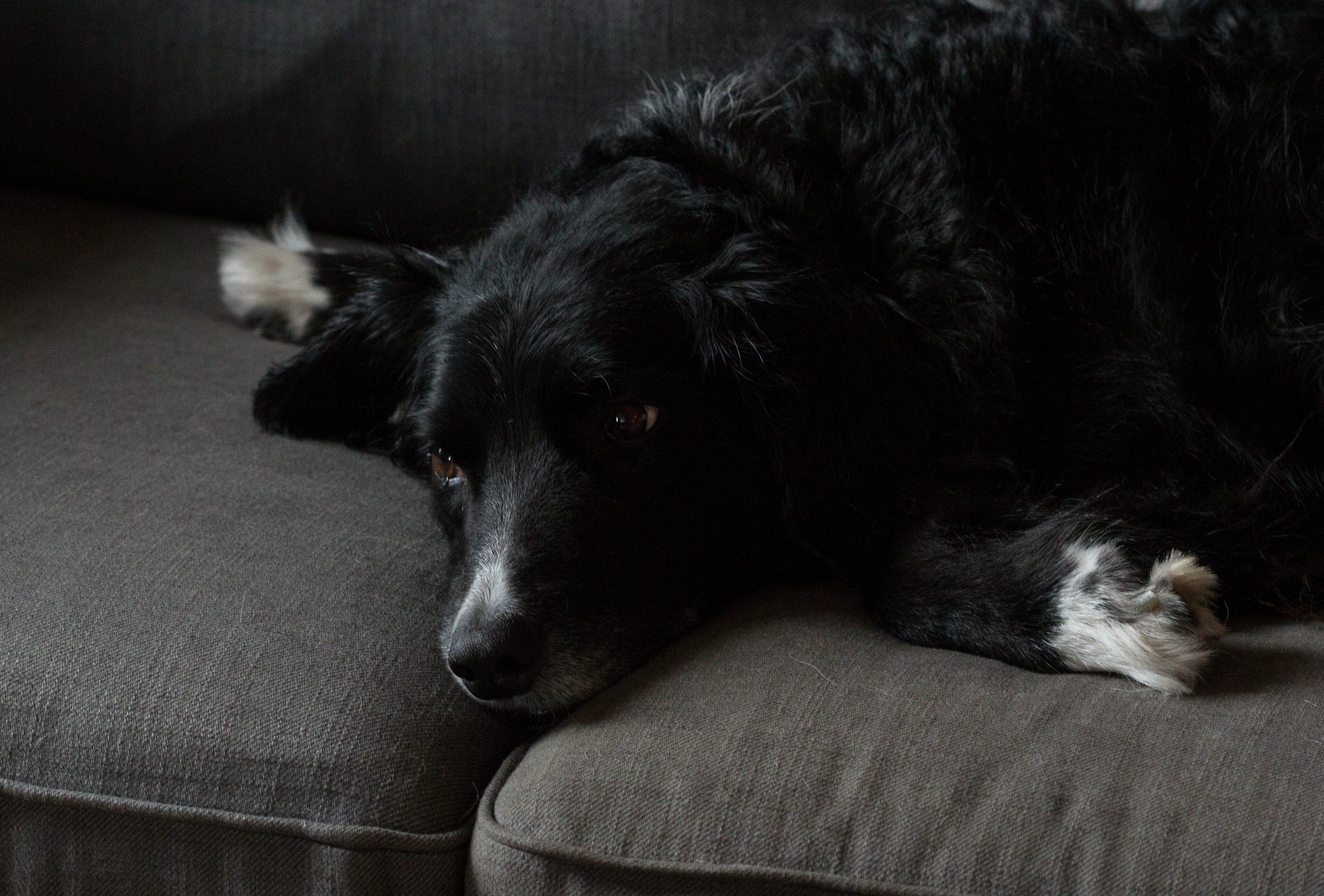
So it’s been two weeks since The Dog’s departure — don’t worry, this is not another 3,000-word canine bio — and he still flickers in and out of daily life.
For example: I’m realizing that I always thought about Scout when I left the house. How long would I be gone and how would he handle it? And I always thought about him when I came home. How soon could I get him out in the yard or out on a walk? It’s a subtle thing, but he’s still woven into that thinking, many times a day.
Walking nearby streets, I realize Scout’s absence has changed my relationship to the neighborhood; because his relationship to the place had become my relationship to the place — to our neighbors, to all the friends he had and still has here.
Scout at Carrizo Plain in 2014. Kate found him on the edge of Soda Lake, the white expanse in the distance, during a visit in 2006.
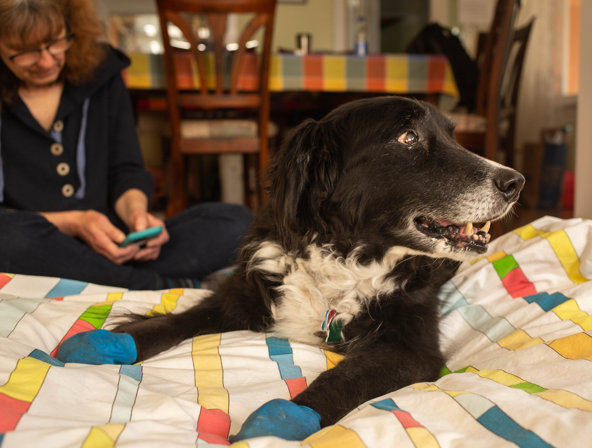
Twelve years ago this month, our lives changed in a way we never saw coming: A dog found Kate in the California outback and adopted her, and us.
By way of explanation: We were down in Paso Robles, at the southern end of the Salinas Valley, for a long Saturday bike ride I was doing. While I was pedaling all over hell and gone with my friend Bruce Berg, Kate went off for the day with Bruce’s wife, Linda Artel, and some of her friends for a visit to the Carrizo Plain.
For the purposes of the present tale, the main thing to know about the Carrizo Plain is that it’s not close to anything. It lies in the lee of the coastal ranges to the west, and you need to cross a mountain range to the east to get to the dry southern end of the Central Valley. From Soda Lake, the alkali mudflat at the heart of the plain, it’s a long, dry trip to anyplace where people live.
So Kate’s group got a surprise as they joined a ranger’s tour on that clear, hot Saturday. Strolling along a plank walk on the edge of the lake, a boy in the group called out, “There’s a dead dog.” A dog’s tail was sticking out from beneath the walkway. When the ranger climbed down to investigate, the tail began wagging — its owner wasn’t dead after all.
In fact, there were two dogs that had sought shelter in the meager shade afforded by the walkway. The one with the wagging tail emerged immediately, covered in gray mud — the boy who had spotted him called him “Dusty.” The other dog refused to come out — maybe too scared or too exhausted to respond to the ranger’s coaxing.
But “Dusty” went with the group back to the ranger’s truck. The ranger tied a rope to the dog’s collar, and Kate, with the group’s encouragement, took charge of him. He drank some water and ate a little turkey from someone’s sandwich. When the group got to its next stop, a trail leading to some Native American pictographs, Kate stayed with the dog, whose coat was beginning to show through as the mud and dirt covering him began to fall away. He looked like he was actually black, with a white chest — a border collie, maybe — and Kate was taken with him.
The feeling was mutual. When Kate left “Dusty” with Linda so she could go off and see the pictographs herself, the dog stared after her and didn’t relax his attention until she returned.
The ranger had said at some point that he would have to drive the dog to an animal shelter in San Luis Obispo, about 70 road miles away. Kate wrote down her contact information and told him she’d be interested in the dog if no one claimed him.
“You know, you can take this dog now if you want him,” the ranger said, adding it was very unlikely that anyone would come looking for him. That was because the dog probably was not lost but had been abandoned on the desolate plain.
Kate was reluctant at first. She hadn’t talked to me, for one thing, and we were staying in a motel that didn’t allow pets. But Linda and the other people in the group urged her to take the dog and even said they’d keep it for her overnight if necessary. So she agreed to take the dog, who was alert and friendly but still so weak that Kate had to lift him into the back of our van.
When she got back to Paso Robles, she set about taking care of business. She went to one of those big-box pet stores, where she hoped to give the dog a bath. But since it wasn’t clear he’d had his shots, the store wouldn’t allow it. So she bought pet shampoo, a big towel, a bed, food and other supplies and brought the dog back to our motel. A woman at the front desk said not to worry about having the dog in our room as long as he didn’t make a racket. “Try to keep a low profile,” she said. Kate bathed him — it turned out he had white paws — and afterward the dog fell asleep.
Remember that I was out there somewhere on my bike all this time and had no idea any of this was going on. Thinking back, I’m remembering the last leg of the ride, through the hills south and east of Paso Robles, and making my way back to town a little after dark, alone. I got to the finish area in the town square and thought I’d see Kate, who I figured would want to share my triumph. But she was nowhere to be found, and she didn’t answer when I tried to call her cellphone.
I may have been peeved. I went back to the motel, just a block or so away, and wheeled my bike toward our room. The window was open.
“Kate?” I called. There was a pause. Then she said, “Wait a minute — there’s a … a … a being here.” She didn’t want to say “dog” in case someone heard her.
I’m not sure I said, “Being?!?” out loud, but that’s what I was thinking. When I opened the door, I saw what — who — she was talking about.
Kate’s recollection is that my first words were, “So we have a dog now?” All I remember was that the dog was quiet and put up his paw to shake when I approached. And yeah, he was a good-looking hound, too.
Scout, on our Ikea couch, waiting out a prolonged rain in 2014.
That night, Kate said she wanted to give the dog a classic dog name, something short. One syllable.
My first suggestion: “Richard Milhous Nixon?” I wasn’t serious — why would you do that to an innocent pet? — but I actually like the idea of naming a dog “Nixon” for its sheer improbability.
“No,” Kate said.
“How about ‘Scout,'” I said.
And that stuck immediately.
The next morning, Scout had recovered to the extent that when we went to get in the van to drive back north, he jumped in the back by himself. When we stopped at a Starbucks on the way home and Kate went inside, he stood guard at the door until she came back out. She was already, and would always be, his pack leader.
Back in Berkeley, we did what you do with a newly adopted pet found wandering in the backlands. He was skinny and full of worms, ticks and foxtails, and we took him to the humane society for a checkup. The vet pronounced him basically healthy. “He’s a good dog — a really good dog,” the vet said. Maybe a year and a half old.
But he pointed out a couple of things that he thought were odd: the little incisor teeth in his lower jaw were badly worn, as if he’d been chewing something hard, like rocks or maybe a chain. Also, he had a recent-looking incision that showed he had been neutered.
What was the story there? Had he been tied up for a long time somewhere and worn his teeth down chewing on things? Had he been in a shelter where he’d been fixed as part of an adoption process? He hadn’t been microchipped, so there was no history to go on.
We always wondered how he had wound up in the back of beyond. Maybe a week after we brought him home, I called down to the visitors’ center at the Carrizo Plain National Monument to see if anyone had reported a lost dog. As I recorded at the time:
“No,” the woman at the center said, “and let me tell you what happens with these dogs. People come out here and just leave them, no water, no food, nothing. It’s a real bad deal.” Occasionally, she said, herders will shoot the strays to keep them from harassing sheep grazing in the area. Starvation or thirst or coyotes take care of most of the rest, though occasionally the monument’s rangers will catch a dog and take it to the animal shelter in San Luis Obispo.
“This is far enough off the road that you can put the dog out and drive away and they can’t chase you,” the visitors’ center woman said. “People split up and decide they can’t keep their dog, or they don’t want to take it to the shelter — over in Taft you just put the dog down a chute and they usually just put it to sleep. But this is a bad deal. You wonder what people are thinking.”
The mystery only deepened over the ensuing months and years. Scout was sweet-tempered, well-behaved, and very quick to learn. He was already house-broken. He didn’t go nuts and chew things up when we were out of the house. It took me all of a week or so to teach him what I wanted him to do — top priority: stop at corners and not go into the street — when I walked him off leash.
He was opinionated, letting us know where he wanted to go and what turns we ought to make when we were out on walks. He remembered the routes to the stores and cafes around town that were reliable sources of treats and tried to get us to visit them often.
He was bright-eyed and handsome to a fare-thee-well, and strangers often commented on how good looking he (or, as they often thought, she) was. He was patient, attentive, loyal, goofy and funny. He put up with long car trips. He loved to be outside and walk and walk and walk. He was good with kids and other dogs and even the backyard chickens.
He left an impression on the neighborhood and on us — on people who would see him and greet him regularly, and on us as we traveled nearby blocks. “Scout’s choice” meant a walk where we’d follow his turns. “Fancy crossing” was a diagonal crossing at an intersection. “Boring way” was our walking route through the neighborhood on our routine walk before bed; “interesting way” was an alternate route through the little shopping district nearby. “Through the grotto” was a shortened nighttime walk. Past “head grabber” was the route past a nasty rose bush growing low over the sidewalk.
To be fair and balanced, he had a few drawbacks: He was a little slow to learn what skunks were about and took a couple of direct hits in the face. He was a cadge, and especially in his bad-breath old age had a terrible habit of sitting next to us when we ate pizza and panting in expectation of the crusts he was sure would come his way. He was a fiend for any discarded food item, regardless of provenance, age or wrapping, that he sniffed out on the streets, sidewalks, lawns and shrubbery along our walks; I don’t doubt that I occasionally left strangers with the impression his name was “Goddamnitscout.”
Kate has always pointed out that whatever had happened to Scout before he was discovered on the edge of the dry lakebed, he was an optimist by nature, a trusting soul, and smart enough to weigh the odds of survival. When people had happened across his little shelter, a place where he could well have died if help didn’t arrive, he ventured out to greet them, tail wagging.
In short, he was amazing, and an amazing find to make out there in the wild. For years, right up to this week, I wished Scout could tell us what or who brought him there, what his name was before Kate found him.
One thought I had over the years about his apparent abandonment: Maybe he was put out on his own because whoever had him before didn’t think he was fit to be a working dog. He had a border collie’s smarts mixed with some other breed’s reserve and calm. When he was young, he was energetic and fast and loved to run — herding other dogs and leading the neighborhood greyhound, Porter, on intense but inevitably short chases. He didn’t show signs of discomfort. But a neighbor, Alice, who became one of his best friends, observed the first time she saw him walk that it looked like he had hip dysplasia.
That was never a formal diagnosis, but it became apparent as he aged that Scout was big and strong in his front end and rather stiff and weak in his back end. He compensated. We went on long, long walks from our place up into the hills and back, and he never shrank from long flights of stairs or steep trails or any other stupid thing I asked him to undertake.
That changed, though, and in the last couple of years, that trend became much more pronounced. He stopped wanting to go on the longer walks. The weakness in his hindquarters became more evident, and he could no longer raise his tail, let alone wag it. He was done with stairs, except for the descending variety. He slowed way down and sometimes dragged his back legs to the point where you could hear his back claws scratching on the sidewalk. What might have once been a 10- or 15-minute walk took a half-hour, then longer. He began panting loudly even making what seemed to me to be a mild effort. He became incontinent and for the first time started leaving dumps on the floor with enough regularity that we’d have to remind ourselves to watch for them if we got up in the middle of the night. On top of all that, he seemed to have gone nearly totally deaf and his eyesight seemed to be failing.
But he was still himself, sweet and most content, we thought, just hanging out with us. And he was as focused as ever on his pack leader, following Kate around the house, monitoring her comings and goings.
Over the past six months or so, we had started to talk about whether, or when, we might need to do something. By “doing something,” I mean “put him to sleep.”
It was a strange and fraught conversation for both of us.
Strange, for me, because even though I grew up with many dogs — Pooh Bear, Flag, Lizzie, Chip-Chip, Dulcey (short for Dulcinea — our mom being a fan of “Man of La Mancha”), Posey and Angus, among others — putting them to sleep had never really been a consideration. Nature or high-speed traffic intervened to shorten the lives of virtually all of them. For instance: Pooh Bear, our first dog, a beautiful springer spaniel mix, lay down and died at Mom’s feet after her treatment for heartworm.
And fraught, obviously, because here we were, Scout’s people, pondering ending a life that he couldn’t tell us he was enjoying or not. We wanted to do the best we could by this noble, dear creature and do it with the understanding that we were on our own in making it.
One thing Kate and I agreed on was that we didn’t want to see Scout reduced to a state of utter helplessness or to be in a situation that required some sort of emergency response. The week before last, we got a chance to see what “utter helplessness” might look like. For most of a day, Scout was unable to stand up without help and could only walk with some difficulty. So we decided to act.
Vets here in Berkeley — and probably many places — will make house calls for those who have decided to put their pets to sleep. It’s a way of avoiding the stress of bringing a sick or dying pet into the clinic for an inevitably traumatic procedure, and perhaps a way of taking some comfort in the last moments of a companion.
Our appointed time was late last Monday afternoon.
Last portrait: April 30, 2017. Scout was the best.
Having worked over the previous weekend, I stayed at home to get things ready. I vacuumed and mopped and cleaned up a little — why exactly I can’t tell you — and I took Scout out for our last walk together.
My grief had crystallized around two thoughts: First, that what we were about to do was final — very final, with no turning back. And second — and most painful for someone who has always experienced a pang of sorrow at endings — that this chapter in our lives, the Scout chapter, the story of being alongside this being, as Kate had called him so long ago, was about to be over.
Beyond that was the fact Scout was such a presence — and a reliably cheerful one — in our lives. Even shuffling along in the way he was reduced to doing in his last few months, he seemed to relish being out with his pack.
The afternoon arrived. Thom came over, and Kate got home about an hour before the vet was scheduled to arrive. We spent the late afternoon sitting with the dog, and Kate read something she had written:
“Twelve years ago, when you joined our family, you had only a collar, and your whole wonderful self. We called you Scout, and you always liked to lead us. We can’t follow you now, but our love and thanks follow you and stay with you. Good dog, Scout. You have always been a good dog.”
The vet and her technician got here a few minutes late — I was glad for even that little extra time. They set up for their procedure: They’d give Scout a strong sedative that would calm him after a few minutes, then an overdose of an anesthetic that would stop his heart.
The dog was a little agitated. He knew something was up — all these people hanging around all of a sudden, and maybe he picked up the scent of the veterinary hospital, too. But we calmed him. The drugs were administered, and he was gone. The vet and technician bundled him onto a litter, carried him out to their station wagon, and departed.
And now? Well, Scout is still here in lots of ways, but most in our expectation that he’ll be waiting for us when we open the front door or eager to go out for his morning walk. That will pass, I guess. Eventually.
At Mackerricher State Park, just north of Fort Bragg, in January 2018.
“The bay of San Francisco is separated from the sea by low mountain ranges. Looking from the peaks of the Sierra Nevada, the coast mountains present an apparently continuous line, with only a single gap, resembling a mountain pass. This is the entrance to the great bay, and is the only water communication from the coast to the interior country. Approaching from the sea, the coast presents a bold outline. On the south, the bordering mountains come down in a narrow ridge of broken hills, terminating in a precipitous point, against which the sea breaks heavily. On the northern side, the mountain presents a bold promontory, rising in a few miles to a height of two or three thousand feet [Mount Tamalpais, earlier called Table Mountain]. Between these points is the strait — about one mile broad, in the narrowest part, and five miles long from the sea to the bay. Passing through this gate,* the bay opens to the right and left, extending in each direction about 35 miles, having a total length of more than 70 and a coast of about 275 miles. It is divided by straits and projecting points into three separate bays, of which the northern two are called San Pablo and Suisun bays. …”
*Called Chrysopolae (Golden Gate) on the map, on the same principle that the harbor of Byzantium (Constantinople afterwards) was called Chrysoecras (golden horn). The form of the harbor, and its advantages for commerce (and that before it became an entrepôt of eastern commerce,) suggested the name to the Greek founders of Byzantium. The form of the entrance into the bay of San Francisco, and its advantages for commerce (Asiatic inclusive,) suggest the name which is given to this entrance.
A graphic depicting California-Nevada River Forecast Center precipitation outlook for Feather River basin above Lake Oroville (the reservoir is at lower left, just upstream from the town of Oroville). White shading indicates areas forecast to receive more than 7 inches of rain between Thursday and Sunday morning. (Click to expand image.)
Not so long ago — through late February, say — the news about California’s “wet” season was how dry it had been. But that changed last month, when a series of late-season storms pulled the state back from the brink of a return to deep drought.
As the last March storm departed, I heard people asking, “Is that it? No more storms?”
But model-watchers saw a return to wet weather late this week, and those supercomputer prognostications have been borne out in the form of a very warm, very wet storm that is forecast to dump huge volumes of water over the northern two-thirds of the state.
One of the regions forecast to get the heaviest deluge is the Feather River watershed, above Oroville Dam and Lake Oroville. That’s news because the California Department of Water Resources, which owns and operates the dam, may be forced sometime in the next few days to release water down the dam’s half-completed spillway.
The image above is from the California-Nevada River Forecast Center, and it depicts a precipitation forecast for more than 7 inches of rain in parts of the Feather watershed over the next 72 hours. (There’s an interactive version of the map on the CNRFC site, here.) DWR has, without a doubt, modeled the expected runoff from that much rain falling so quickly, how fast the lake will rise, and when it will reach the “target” elevation at which the spillway gates will open and water will flow down the 3,000-foot-long concrete chute.
As of this morning, the reservoir is about 20 feet below the lip of the spillway inlet and about 37 feet below the target elevation of 830 feet above sea level. From outside, it’s hard to guess how quickly the lake might rise — that’s a function of the total precipitation, how saturated soils in the watershed are, how much snow might melt off in the watershed’s upper reaches, and how much water is released from the reservoir through the only currently available outlet, the dam’s hydroelectric plant. But given the rate of the lake’s rise during the last round of heavy rain, it would appear that it would be late next week before that 830 foot threshold is reached.
The memory’s a jumble. We lived in the woods, at the end of a long driveway. It was already dark. And raining — cold April rain.
But we were inside when the news came. Our early evening habit was to watch “The Huntley-Brinkley Report,” NBC News’s nightly national broadcast, which aired in the Chicago area at 6 p.m. Before the show signed off for the evening — the show’s closing credits would roll while a passage from Beethoven’s Ninth Symphony — there was a bulletin from Memphis: Martin Luther King had been shot. His condition was unknown, but one report suggested he’d been shot in the head.
Dad wasn’t home yet. Mom was out shopping. I had to tell someone. I saw Mom pulling into the carport, and I ran outside to tell her that King had been shot.
She had taken us to see him speak once, less than two years earlier, at Soldier Field. The beginning of a long, bitter summer of fair-housing protests in Chicago. That same summer, I think, Mom had gone to see King at a church on the South Side. I remember her saying she was in a pew on the aisle of the church and that King brushed past her as he walked up to the front of the church. She was surprised he wasn’t taller, but that as he spoke he seemed transformed — to grow not only in intensity but in stature and command.
Now something terrible had happened. Martin Luther King had been shot.
It’s my sister Ann’s birthday today. And here’s the outline of a brief story I’ve often told on the occasion.
The year was 1962. I was nearly eight years old, and I’m not sure I grasped the import or meaning of anything that was going on around me, but yes, there was a build-up to a major family event: Our mother was expecting, and the big day was fast approaching.
I remember riding along as Dad drove Mom to her obstetrician appointments with a Dr. Kenwick — Anthony Kenwick, I think, who turns out to have been a fairly well-known practitioner. I remember her relating his reaction to her earlier childbearing history. My Norwegian father and Irish mother managed to have what you might call Norwegian-Irish quadruplets; four boys who arrived in less than four years — April 1954, September 1955, December 1956 and March 1958.
Mom said Dr. Kenwick took this in and asked, “No bundle from heaven in 1957?”
Back to our story. The morning of March 26th. Mom had started to have regular contractions. Dad was staying home from work. Every time Mom reported a contraction, he’d check the time on his watch and write it down on the back of an envelope. Did I understand why? I’m not sure I did. But I think both Mom and Dad said the new baby might arrive today.
My brothers and I went off to school, just a couple blocks up the street at St. Mary’s. I was in 3rd grade, John was in 2nd, Chris was in 1st. We went home for lunch. Mom and Dad were still there, and Dad was still writing down times on his envelope. We went back to school.
We got out of class about 3 o’clock and started for home. The walk was down Monee Road, at the southwestern corner of Park Forest, and the road had (and has) a pronounced right-hand bend as you headed from St. Mary’s to our place just the other side of Indianwood Boulevard.
Just past the bend, I looked up the block and saw our car, a red-and-white 1958 Ford station wagon (with a three-speed manual transmission), turn the corner up Indianwood. I figured that was Mom and Dad headed for the hospital — Ingalls, in Harvey, which through the magic of modern online maps I see was about 10 miles away.
When we got home, our neighbors, the Lehmans, were waiting for us. They told us what I’d already guessed — that our parents had left for the hospital. We were parked over at the Lehman place for several hours. As I recall it, they got a call about 6 o’clock that the baby — a sister! — had just been born.
Mom, no doubt, was enjoying her evening away from us and the peace and quiet of a busy maternity ward.
Dad came home later, probably fresh from trying to explain to his mother, Otilia Sieverson Brekke, why the baby’s name was Ann — almost the same as Anne Hogan, Mom’s mom. (Ann’s middle name is Margaret, and I think Dad only half-jokingly insisted that she had been named after Ann-Margret, the Swedish-American actress. Grandma Brekke got over it, I think. I remember her referring to Ann as “Tuula,” a Norwegian girl’s name that she seemed to use as a fond reference for her only granddaughter.)
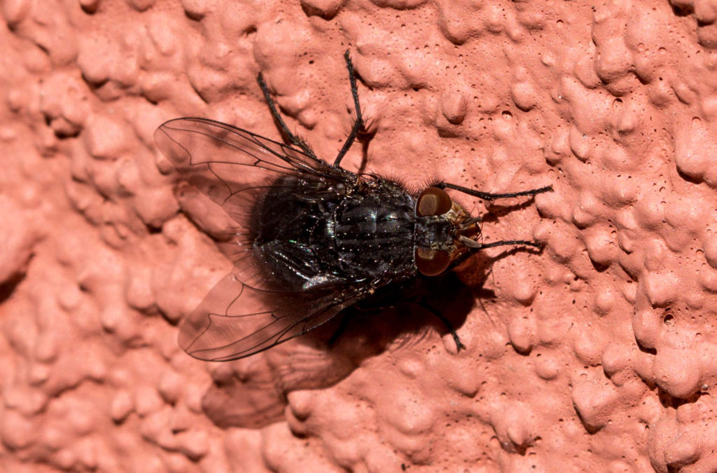
On the wall at the rear of our house. It’s a blue bottle fly — either Calliphora vomitoria or C. vicina.
We had a flicker — you know, a kind of woodpecker — in the backyard this morning. And a robin and a bunch of sparrows. And an anise swallowtail butterfly that was hanging out in a little anise bush that’s regenerating itself after being cut to the ground last year.
But above is what I got a picture of: a fly.
A blue bottle fly, perhaps Calliphora vomitoria (Linnaeus 1758), or perhaps Calliphora vicina (Robineau-Desvoidy, 1830).
Both species are part of a group known as blow flies. I won’t dwell on their habits — we all sort of know what flies are up to for a good part of their lives. But like everything else that flies, buzzes, creeps and crawls around us — except maybe mosquitoes — these flies fit in somewhere. Here’s what the Encyclopedia of Life (with its British spellings) has to say about C. vicina under the category “benefits”:
Unless there is something to prevent their access, blowflies will rapidly colonise a human corpse. For this reason, they are frequently encountered by police who are investigating suspicious deaths. It is now recognised that an exploration of the insect community on a corpse can contribute valuable information to the forensic investigation and the field of forensic entomology is relatively well established. Due to their ability to locate corpses so quickly after death, blowflies have proved more useful than any other insects in giving an estimate of the minimum post-mortem interval (the time elapsed since death). To do this the forensic entomologist models the growth of the blowfly larvae recovered from the remains in relation to the scene temperatures. To date, the forensic entomology team at the Natural History Museum have been involved in some 120 forensic cases. Calliphora vicina was the primary blowfly species recovered in most of these.
And here are benefits attributed to C. vomitoria, which could prove valuable at a time when we seem to be killing pollinators:
Although blue bottle fly larvae eat carrion, the adult flies frequently feed on flowers with exposed nectaries. Pollen grains become attached to the flies’ body hair and are moved from flower to flower as they search for nectar, a process known as incidental pollination. Typically the blue bottle fly visits flowers with a strong odor often resembling rotting meat. Plants pollinated by the fly include the American pawpaw (Asimina triloba), dead horse arum (Helicodiceros muscivorus), skunk cabbage (Symplocarpus foetidus), goldenrod (Solidago spp.), and members of the carrot family like Queen Anne’s lace (Daucus carota).
At the North Central Regional Plant Introduction Station (NCRPIS) in Ames, Iowa, both the blue bottle fly and the common house fly (Musca domestica) are used to pollinate plants of the carrot family in the field and greenhouses. Several farms have used blue bottle flies to successfully pollinate vegetable crops including carrots, broccoli, lettuce, and canola. As managed pollinators, the blue bottle fly is non-aggressive to humans; the pupae are cheap to purchase and can be stored for three weeks; and the flies work in smaller areas and at cooler temperatures than bees. For these reasons, the blue bottle fly is actually being used as an alternative to bee pollinators.
I tried and failed to discover what the Latin word “vomitoria” means in the species naming context. I note, though, there appear to be more plant than animal species named vomitoria. Ilex vomitoria, for instance.
Flowering quince, just up the block from the old Adams place.
Today it rained. Those droplets on the flowering quince up there above are the proof. Our non-fancy rain electronic rain gauge reads .04 of an inch for the day. And since this was the first rain since January 25, that makes .04 of an inch for the month, too.
As California climatologists are quick to point out, longish dry spells are not unusual during California’s wet season. But this long dry spell matches one we had in December, when we got just .12 of an inch. Those two dry months came sandwiched around a pretty average January — 4.77 inches according to our rain gauge. So adding up the last two and a two-thirds months, we’ve gotten less than 5 inches of rain, total.
As in most of the rest of California, December, January and February are the three wettest months of the year. The official Berkeley record shows an average total for those three months, since 1893, of 13.16 inches. The December-January-February average for the 1981-2010 climate “normal” was significantly higher — 15.23 inches. (That’s a pretty wide spread, and it’s probably due to many months of missing data over the last 125 years.)
A year ago — our one really wet winter in the last six, we got 9.85 inches in February alone. Our D-J-F total for 2016-17 was 28.63 inches.
Of course, February isn’t over yet. More chances of rain are forecast over parts of Northern California for the next week. We’ll see how that pans out.
What the remaining “asphalt” looks like on Holly Street after sweeping away the gravel on the surface.
Editor’s note: The following is not whining.
Now that that’s been established, a brief tale about our short street in North Berkeley. We moved to the street several presidential administrations ago — during the tenure of the Republican before the Republican before the Democrat before the Republican before the Democrat before the current “Republican.”
“Nearly three decades ago” would also put you in the right historical neighborhood.
The street was paved within three or four years of our arrival. Not a big deal. The pavement hadn’t seemed terrible. But new, smooth asphalt seemed like a luxury.
That’s the last time the street was paved, and over the past 10 years or so, it became apparent the asphalt was breaking down. There’s lots of gravel on the paved surface. The rocks still embedded in the asphalt seem exceptionally sharp; if you happened to fall while cycling or running down the street, you’d be cut to ribbons. And much of what’s left of the pavement is eroded into little rills and gullies. If you sweep away a patch of gravel and look at it in the right light, it’s kind of beautiful.
Naturally, some of us on the street have told the city of Berkeley we’d be interested in seeing the street repaved. Year after year, the street hasn’t made it onto city’s list of upcoming paving projects. This past spring we sent a brief petition into our councilmember, the mayor and the Public Works Commission asking for the street to get attention. Last week, public works presented its list of streets to be repaved over the next five years, and we weren’t on it.
We’re not sure what, if any, recourse we have, except maybe to make more noise. In the meantime, I sent a letter to the chair of the Public Works Commission. That note (first) and her reply, are below:
Me:
I offer the following with the knowledge there are much bigger issues in the world than patches of local asphalt and with a determination not to get my blood pressure up or give anyone else too much grief over something as transient in the cosmic scheme as pavement.
If I’m reading the agenda item from last night’s council meeting correctly, Holly Street has not even made it onto the 2018-2022 street rehabilitation plan. (Question 1: Am I reading that correctly?)
I assume this is at least partly due to Holly being a non-arterial/non-collector street and thus lower priority — though I note that residential streets are getting “priority” in fiscal 2018 and also that plenty of similar residential streets in no worse condition than Holly have been repaved in the recent past or are now scheduled for repaving. Having skimmed the presentations for last night’s council meeting, I also know that funding is an ongoing challenge (for paving and every other kind of infrastructure).
Question 2: Do we have any recourse to the plan adopted last night? I mean, besides complaining to a council member who’s hearing the same kind of thing from all quarters and doesn’t seem to have much power to get our street on the list?
I think I’m at the point where I’ll suggest to neighbors that we start planting stuff in the street — there seem to be plenty of receptive areas in the remaining pavement for wildflower seeds, native grasses, etc. — and let nature really take its course. Maybe the city can adopt us as a street reclamation pilot project.
From PWC chair:
You are correct the Holly Street is not currently in any of the staff plans for repaving. On the plus side, at the end of a very long meeting last night, Council approved only the first two years of the staff proposed plan, so there is room discussion on the 2020-2022 plan years.
Your street is now in the horrific position of being too broken to maintain. Having said that, we made some incremental progress in the implementation of policy on 15% of funding available for discretionary projects. The PWC continues to recommend that once streets fail and require reconstruction, that is a good time to look at alternative technologies. As you have already expressed your neighbors’ support for green infrastructure, Holly St may be a good candidate for a demonstration project.
As the mandate to the PWC directs us to address the Paving Plan’s compliance with policy rather than specific streets, I think we should work with Linda Maio to discuss how to raise specific street concerns and find a fair and equitable way for us as citizens to 1) know the status, quality ranking of streets we are concerned about as individuals, 2) understand our individual priority streets in the context of a citywide perspective of work needed and limited available funds, and 3) develop a transparent forum that provides an avenue for citizen input to the street rehabilitation plan.
The PWC will be working to provide policy recommendations to the Council over the coming few months and I will keep you posted on our progress, looking forward to your input and suggestions. Thank you for your concern, communication, and delightful technical recommendation.