Road Blog: Kansas City to Lamar, Colorado

elmdale040409.jpg

Got a late start from Kansas City this morning, and took our time in Chase County–home of the Tallgrass Prairie National Preserve–before doing some serious driving starting at about 2:30 in the afternoon. Well, we had lunch in Cottonwood Falls, the Chase County seat, and since we had just one key for the car and were concerned about locking it in the car–we stopped by a general dry good store with a sign that said it made keys. Getting the spare key was a half-hour process that involved the store proprietor expressing doubts about his ability to cut a two-sided key, a long search through the blanks he had in stock, and a digression about a locking gas cap that once had failed him. We did not hurry him along. Finally, he chose a blank he thought might work since he didn’t have the one specified for our Toyota Echo, and cut it with no problem. He said he thought it would work in the car, took our buck-eighty, and we were on our way. The new key works fine and all we have to remember to do now is not to leave the spare key in the car where we won’t be able to retrieve it when we lock the other one inside the vehicle.

We also wasted some time trying to locate Kansas Highway 150, which our map sort of implied might head west from Cottonwood Falls. Eventually we found it, but not before driving back and forth on a back road that goes past the town fishing lake and through a dying hamlet called Elmdale–still on the map–just off U.S. 50.

Elmdale looked desolate and much the worse for wear. Only one business appeared to exist in town–a grocery that except for the soda vending machines outside looked like it might be shut down. Just down the main street from there was a small edifice built from the same sandy-colored limestone that appears in many substantial buildings in the area. It was the city hall, built (according to an inscription at the lower right of the picture) by the Works Progress Administration in 1936.

Chris remarked that the place reminded him of a desperately poor town in eastern Kentucky, Pineville, that we had driven through with our dad in 1966. The shattered houses, some abandoned, some still occupied, reinforced the impression. So did the scruffy city park and the nearly empty streets. The one sign of activity was someone unloading a truck full of wooden pallets, adding them to the hundreds of pallets already stacked near one home. I wondered whether they were intended as firewood.

There’s a story to the town, one that naturally is not evident from a five-minute look at the place. By way of the town’s Wikipedia entry, I came upon a terrific (though undated) story from the Emporia Gazette that chronicles the town’s decline over the past 60 years, mostly due to a series of floods. The piece is accompanied by some nice shots from a Michigan photographer, Galen Frysinger.

Trip coordinates:

Departure point from Chicago: 42 degrees, 0 minutes, 32 seconds N. latitude
87 degrees, 41 minutes, 21 seconds W. longitude

Day One stop: 39 degrees, 6 minutes, 52 seconds N.
94 degrees, 45 minutes, 46 seconds W.

Day Two stop: 38 degrees, 6 minutes, 13 seconds N.
102 degrees, 37 minutes, 6 seconds W.

Home (Berkeley): 37 degrees, 52 minutes, 39 seconds N.
122 degrees, 16 minutes, 53 seconds W.

Comment: We’re within a quarter degree of our destination latitude. We’re about 20 degrees east of it. I don’t believe we’ll find a straight-line route.
Road Blog: Chicago to Kansas City (Kansas)

leaning041309a.jpg

My brother Chris, his son Liam (he’s 12), and I started out from Chicago to drive to California. I’m actually doing an errand–picking up my dad’s car and bringing it out to Berkeley–and since it’s spring break for them, they’re along for the ride.

To break up the Interstate highway slog, I like to get off on side roads occasionally. I suggested the possibility of driving out U.S. 20 through northern Iowa and northern Nebraska to northeastern Wyoming, and then making our way down to Interstate 80 near Rawlins. What I liked about the route: it would take us within about 30 miles of Wounded Knee, on the Pine Ridge Reservation of the Lakota Sioux; it would also take us right past Fort Robinson, Nebraska, the site of a tragic episode in the 1876 saga of the Northern Cheyenne attempt to return to Montana from a reservation Oklahoma.

But the weather along that route: not good. It was supposed to be fine through Wednesday, at which point we’d be starting across Wyoming. But rain and snow, and then heavy snow, are forecast for much of the corridor we’d be taking. The weather along Interstate 40 and other central and southerly routes seemed much less problematic. So we headed southwest from Chicago this morning in the rain.

We stopped early in the afternoon at the Union Miners Cemetery in Mount Olive, Illinois. I happened across this spot with my son Eamon about five years ago when we spotted a highway sign pointing us to the “Mother Jones Memorial.” That had to be investigated, and it turns out Mary “Mother” Jones (1830-1930) is buried there along with many members of the United Mine Workers and other coal-mining unions.

Maybe someday I’ll make a day of it down there. Today, we stopped for 15 or 20 minutes, not really long enough to take in much more than the main attraction. The marker above, with the Leaning Jesuses, is along the lane to the Jones monument (which is just visible in the left distance).

After this, we took state routes and country roads to Grafton, where we took a ferry across the deceptively calm-looking Illinois River (the image below; the river is running high, and much of the lowlands east of the river are under water), then to the Golden Eagle Ferry, which crosses the Mississippi on a bend south of, but upriver from, the mouth of the Illinois.

On the Missouri side the boat unloads you onto a floodplain road that’s less than a 10-minute drive to a freeway that leads into I-70. We skipped a detour to a temporary Missouri River ferry (in Glasgow, where a new bridge is being built), stopped in Independence to see Harry Truman’s place, looked at some of the important Mormon-related sites in town, then crossed the river after dark into Kansas.

Tomorrow we might cross paths with John Brown.  

ferry041309.jpg

Lincoln’s Way

lincoln080107.jpg

Lincoln Highway: Austin, Nevada. August 1, 2007.

So, looking for a little something to say about our sixteenth president on his 200th birthday, I’ve come up a little short. For tonight, just this: You run into him everywhere. I remembered earlier this evening that the summer before last, when Kate and I drove across the country, we encountered Lincoln Highway markers on U.S. 50 in the middle of Nevada (above). That was news to me, because our Lincoln Highway in the south suburbs of Chicago was U.S. 30. The next day, we came upon more markers east of Salt Lake City, in a hamlet just off Interstate 80 (below). It turns out both places were on the route of the original Lincoln Highway route. (Check out Lincoln Highway, a simple but excellent site on the route and its history.) lincoln080207.jpg

Lincoln Highway: Wanship, Utah. August 2, 2007.

Clean Rice

Cleanrice100208A

Last Thursday night, just outside the town of Tsukuba in Ibaraki Prefecture. We were walking along a semi-rural road just after sunset, and, not reading Japanese, I had no idea what this little kiosk was. My son Eamon said, “Well, what would a farming community like this need?” Well, there were rice fields all around us, scattered with single-family homes and small apartment buildings. But I still had no clue what I was looking at.

The large characters on the canopy say, “Kubota Clean.” What I was looking at was a personal rice mill (built by the Kubota company). People bring their winnowed household rice here, dump it in the hopper, put in some money, and this unit hulls and polishes the rice to the finely finished white grain most in Japan prefer. Not sure what the U.S. equivalent would be. A neighborhood flour mill to grind people’s wheat into flour?

Technorati Tags: ,

So, *That* Happened

Item 1: We returned from Japan today. In fact, I’m on my second Sunday evening (we took off from Narita airport, outside Tokyo, at about 7:15 Sunday night; and here it is getting close to 7:15 Sunday night after landing in San Francisco before noon. I understand the why and how of it, but it’s still strange.

Item 2: Before we left, I mentioned to someone that gee, the Cubs might be out of the playoffs by the time I get back home. Just indulging a moment of pre-emptively rueful Cubsy-ness. When we got home early this afternoon I picked up the San Francisco Chronicle, whose Sunday sports section featured not one but two misspelled names in other headlines, and saw the news that the Chicago nine had been swept. You can say wait till next year, or you can just admit you’re not waiting anymore. Go Pale Hose–spoil that beautiful Tampa Bay Rays story for us.

Item 3: Sometime I’ll relate my greatest adventure of September 2008, which was not flying to Japan but running out of gas on the very busy San Francisco Bay Bridge. I believe I’m an unindicted co-conspirator in the event, which involved a faulty fuel gauge.

Item 4: Not to leave the subject of The Trip too quickly: We flew Japan Air Lines both ways to Tokyo. Oddly (or probably not), about two-thirds of the seating space is devoted to first and business class. We were jammed in the back with the other groundlings. One of the entertainments offered on the screens-at-every-seat was a map of our flight’s progress. This morning, I saw that we were nearing the Northern California coast and started looking for Mount Shasta. The mountain is our Fuji, 14,000-some feet, a good hundred miles in from the coast. At the point I started looking, probably near Point Arena, we were about 200 miles from the mountain. But there, way off, rising above the clouds, was that beautiful snowy (not Sno-) cone.

It’s interesting to be back, even after just a week away.

(And where did the post title come from? Watch the clip below. You gotta stay with it to the end.)

Mokuyobi

Tokyo092908

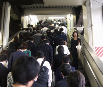
Our last day in Tokyo on this trip. It’s a city reputed to have a daytime population of 30 million as people come in on the network of trains and subways to work. The packing you’ve heard about on Tokyo commuter trains is one effect of the rush into the city. In the evening, the crowd ebbs a bit more slowly. Lots of people stay in the city late, dining and drinking with workmates or friends. The next morning, the tide flows in again. That’s old news, but it’s still captivating to see firsthand.

The trains, whether you’re talking about the superfast long-distance lines like the Shinkansen or the most humble local, are stunning for their speed, efficiency, convenience and cleanliness. I’ve never seen anything that comes close in the United States–though that’s entirely for lack of trying. What the Japanese do with railroads requires a lot of money and a sort of infrastructure context–because the highway network is relatively undeveloped, you wouldn’t want to try a casual 200-mile drive anywhere unless you have a lot of time to burn. Back home, we spend more and more grudgingly on public works projects, but you can be sure that the money that’s out there will go to highways first and to every other mode of moving people second.

Again, old news. I’ll leave the Tokyo chapter with this advice: If you can, go with one of your kids–preferably after they’ve studied Japanese, married a local, lived in the city for a couple of years and have become fluent in the language. That way, you don’t have to worry about details like navigating on your own. In all seriousness, Eamon and Sakura have been the best guides we could have had. In fact, I feel like I missed out on the obligatory foreign-visitor anxiety.

Tonight, we’re in Tsukuba, a small city (by Japanese standards) about 50 miles north of Tokyo and at the end of a brand-new commuter rail line. Tomorrow we head up into the mountains north of here to the hot springs resort of Nikko. And then somewhere in the next two or three days, I guess we get back on a plane and fly to San Francisco. Not sure how much I’ll get to post between now and then. I’ll catch up on one side of the ocean or the other.

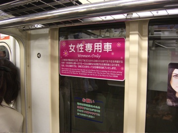
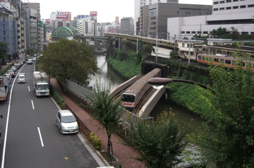
[Pictures (click for larger versions): Above: Up to JR platform at Kanda Station, downtown Tokyo. Below: Notice designating train car as “women only” during the morning commute–a measure taken to give female passengers a way of avoiding groping male riders. Bottom: As seen from Hijiri Bridge, trains cross the Kanda River at Ochanomizu Station.]

Tokyo093008

Cimg7171 1

Technorati Tags: , , ,

Suiyobi: Today’s Top Commercial (and Other) Concepts

Junky100108

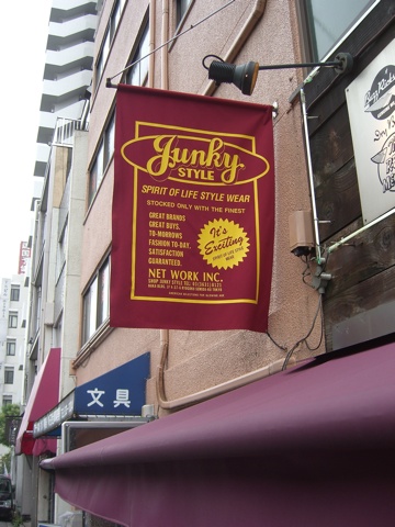
I have a feeling you could spend all day, every day for a long time in Tokyo harvesting signs like these for the consideration and amusement of native English speakers. And when you were done with Tokyo, you’d have the rest of Japan to cover.

We talked a little bit today about English language words and names terms and why they’re popular here. In a lot of cases, it seems they’re employed merely as decoration–no one reads them for a literal meaning; their presence alone lends some sort of smart, cool quality. And somehow that leads to “Junky Style,” “Nudy Boy,” and all the rest.

Technorati Tags: , ,

Kaiyobi

Raincyclist093008

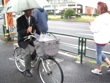
On rare occasions, I’ll see a cyclist in Berkeley try this: riding a bike while holding an umbrella. I saw dozens of people doing so with seeming ease today. This guy was negotiating his way past a tour group on a sidewalk outside the Imperial Palace. Elsewhere, I saw a woman whose bike appeared to be fitted with an umbrella holder–a unit that also incorporated a headlight.

Technorati Tags: , , ,

Getsuyobi

Today (Monday, though we’ve already crossed into Tuesday where I’m sitting), we took a round trip from Tokyo Station to Nagoya on the Shinkansen–the “bullet train.” The distance is about 340 kilometers one way–about 210 miles–and the trip each way took about two hours.

On the Nagoya end of the journey, we took a local train and subway out to the eastern suburbs to visit the Hattori family, who through some daring and generous impulse decided to take in a foreign exchange student in 1976. For me, it was an amazing and revealing day; in a sense, I got a chance to revisit not only the place and people, but unexpectedly to get a look at that long-ago self. Who was that bearish, bearded, wild-haired young gaijin?

And with that question, I’m signing off. It’s just too late tonight to both reflect on the day and write it. I will mention, though, that Kate and I simply couldn’t have had the day we had, or the trip we’ve had so far, without Eamon and Sakura. Their knowledge of the place, which can be so daunting to foreigners, has allowed us to relax in a way that I know I never could if I were doing this on my own. And Eamon’s language skills–astounding.

It’s bed time. O-yasumi nasai.

Technorati Tags: