Mini-Exhibit: Water, Dams, Mulholland, L.A.

Like everyone else who’s walking around with one of these “phones” equipped with a high-quality camera (or are they really decent cameras with mediocre-quality phones?), I take lots of pictures. Sometimes I try to discover a theme in what attracts my attention, but aside from “landscapes” or “birds” or “infrastructure” or “stuff on the street,” I would struggle to name any real thread that ties any of my images together.

But a couple of days ago I was looking a few pictures — just three — I had taken on three separate trips to other parts of California over the last few years and was surprised to see something of a story there.

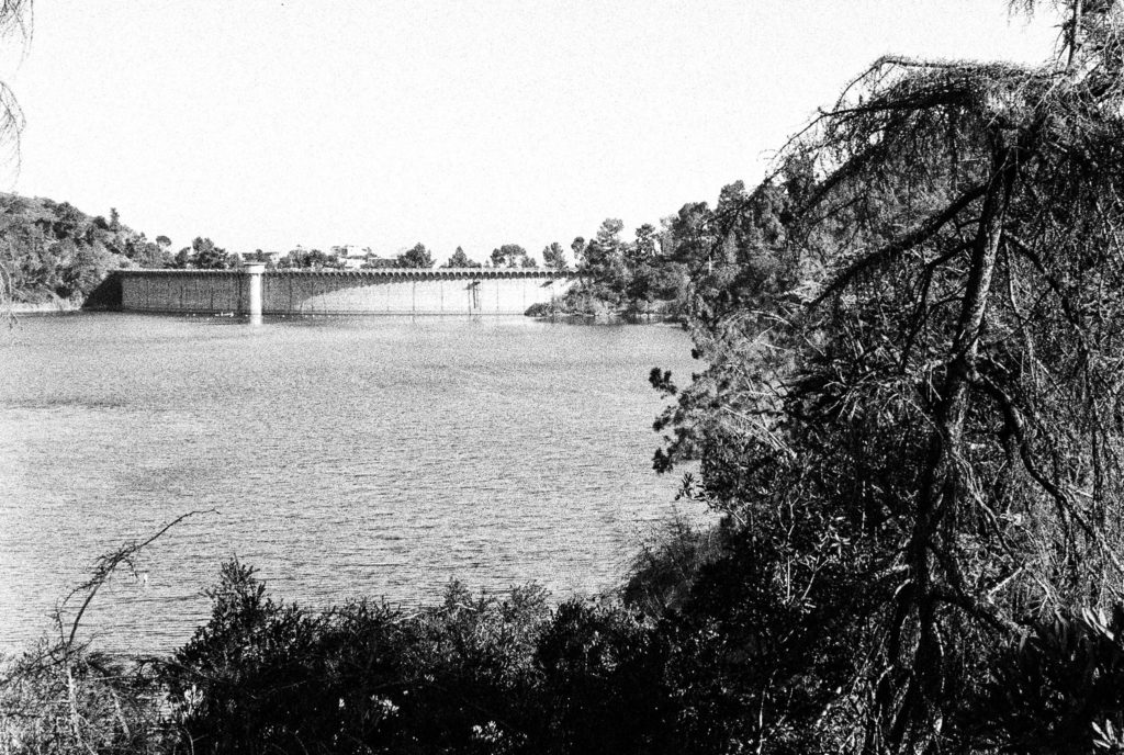
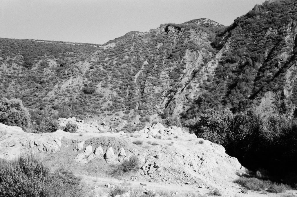
Here are the images:

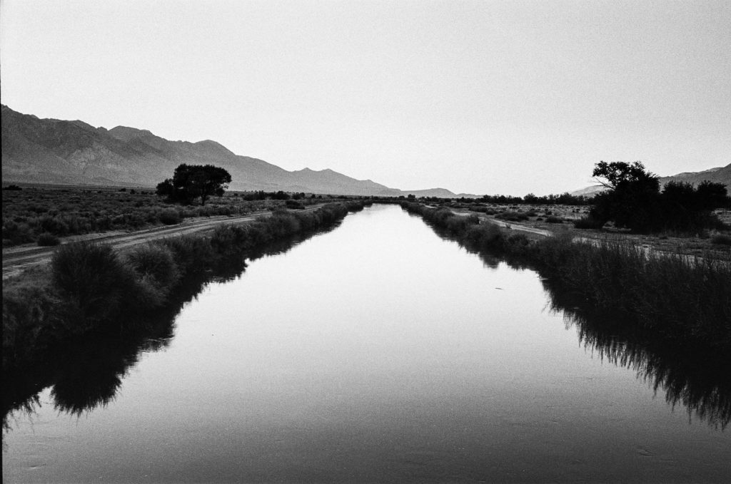
That first shot is the Los Angeles Aqueduct, in the Owens Valley just across the highway from Manzanar, the site of the internment camp where thousands of Japanese Americans were incarcerated during World War II. Kate and I camped nearby, just outside the town of Independence, in 2018. After spending a beautiful September afternoon touring Manzanar, we wandered down to the aqueduct as the sun was setting.

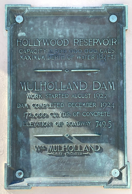
The second shot is the Hollywood Reservoir and Mulholland Dam in Los Angeles. I had wanted to see this place for years, and we made it up on a Sunday afternoon last June while visiting our son Thom.

The third shot shows part of the wreckage of the St. Francis Dam, in San Francisquito Canyon, in northwestern Los Angeles County. The dam collapsed in March 1928, killing about 450 people downstream. You have to hunt a little for the site of the dam, which Kate and I did on the same 2018 trip that took us to Manzanar.

I like the fact all three images were shot on film using relatively antique (1970s-era) Japanese rangefinder cameras. But what ties them together, perhaps obviously, is the connection to Los Angeles, water, and L.A. Department of Water and Power chief William Mulholland.

Mulholland was the principal architect of the Los Angeles water system: He played a leading role in helping secure (or steal, depending on your perspective) the Owens Valley water rights for the city. He engineered the aqueduct that brought the water to Los Angeles. Although he was initially reluctant to build dams and reservoirs to store that water, he designed and supervised the construction of Mulholland Dam, which took all of 16 months to complete in 1923-24. He used that structure as a sort of template for the St. Francis Dam, which was completed in 1926. Mulholland visited St. Francis Dam just hours before it disintegrated and pronounced it sound; the catastrophe ended his career. Although he apparently believed Owens Valley saboteurs were responsible, as they had been for the destruction of some of the aqueduct facilities in the eastern Sierra, he took public responsibility for the tragedy. “Don’t blame anybody else,” he told a coroner’s inquest. “You just fasten it on me. If there is an error of human judgment, I was the human.”

As I say, I just happened to look at the three photographs together the other day and see a story. If I ever have a show, I thought, I’d want to present them as a group. For some reason, I thought a presentation like that would be more complete with a fourth image. I remembered a 2017 visit to Los Angeles during which we stopped at the Department of Water and Power building (a.k.a. the John Ferraro Building), at the corner of First and Hope streets, and just across the way from the Dorothy Chandler Pavilion, the former home of the Oscars.

I took some pictures when we were at the DWP building — all with a digital SLR, not film. Looking back, I found one that I thought I could add to the group — post-processed from color to black and white. It’s looking up from a corner of the building up toward the roof, with the sun just obscured:

What kind of statement is that making? I haven’t come up with words yet, though I like the image. And as I say, if there ever is a show, this one’s going in.

A Moment Amid the Turmoil

I came across the photograph below in the excellent slideshow the Los Angeles Times posted summarizing two days of protests and associated unrest in the city. (The slideshow is part of the Times’ running story on the George Floyd protests. The large version of the image is here.)

To my eye — and I’ve got one good one — this is a thrillingly beautiful image. The combination of the deserted freeway (with the completely jammed adjacent lanes visible), the skateboarder in perfect focus, the police vehicles out of focus down the slope, the spectators on the overpass in the background recording the scene: such subtly balanced elements.

And it’s just a moment. It passed in the smallest fraction of a second. The skateboarder was in motion, no doubt, and everything else, including the photographer (the Times’ Wally Skalij), likely shifted slightly, too, before the next frame fired.

The skateboarder’s relaxed body language belies the urgency and strangeness of his situation. There’s more assessment than defiance in his stance. I have no idea what he was headed for, what he was thinking, whether he was looking for an escape route, or whether there was any way off the freeway without getting arrested. The whole scene kind of reminds me of Steve McQueen trying to outrun the Germans in the motorcycle sequence in “The Great Escape.”

Last, reality has been suspended here. A man engages a photographer in a space that neither would ever inhabit together except in the midst of a catastrophe. The tragedy that brought both of them to this spot is dimly visible here in the flashing emergency lights in the distance. But the pain and rage sweeping over the city and hanging over the world beyond, the police officer throttling the life out of a man on the pavement, the terrible indifference to the dying man’s pleas, have been pushed nearly out of sight. For just this moment.

Nothing's Permanent

The Leader building on Fairfax Avenue, Los Angeles.

On Fairfax Avenue just north of Beverly Boulevard, Los Angeles. The Leader sign is attention-getting — it got mine, anyway, when Kate and I were strolling past last March —but what is/was it about?

Answer: From 1946 through 1989, the building housed a well-known and very busy beauty shop. The L.A. Times ran a very good story on its closing: Nothing’s Permanent: Fairfax Beauty Shop Closing After 43 Years. If you’re too busy for the link, the driving factor was rising real estate prices, and the family that ran the business cashed in on their property.

The July 1989 story notes that two-bedroom apartments in the neighborhood were going for about $950 a month.

Road Blog: Days and Nights in L.A.

The Eli Broad wing of the Los Angeles County Museum of Art on Wilshire Avenue.

I have spent nearly all of the last 42 years in California, and all of that in the San Francisco Bay Area. I’ve visited Los Angeles about a dozen times. I only get to double figures by counting episodes like the time I delivered a drive-away car, a white Chevy Vega station wagon, to its perhaps rueful owner in Venice Beach; and day trips to do interviews for stories I’ve worked on; and visits to Disneyland, which some may dispute involve a visit to “Los Angeles.” It is not an impressive list, especially considering you can’t have any real idea of California without at least a passing acquaintance with this place.

So here we are on Day Three of dropping in for a visit and just … staying put for the most part.

Example of what I mean by “staying put.” Thom and Megan found an apartment that’s a short walk from the Los Angeles County Museum of Art. Today, we went to check the place out and spent the afternoon there (and spent virtually all of the time visiting one exhibit on the evolution and applications, practical and artistic, of three-dimensional imaging technology.

After that, it was back to the apartment, then a hike to the Los Angeles Farmer’s Market — which is actually a warren of dozens of restaurants and shops, including a couple that sell produce, that is reminiscent of the shopping district adjacent to Tokyo’s Asakusa Shrine — to buy some salad stuff for dinner, which was pizza.

Anyway: This is Night Three in Los Angeles — and I believe it’s the first time I’ve ever spent three nights here in a row.

Tomorrow: Breakfast here, then heading out. Only one stop set on the itinerary: the site of St. Francis Dam, northeast of the city, which collapsed 90 years ago this year and killed about 450 people. Considered by many to be the biggest civil engineering disaster in U.S. history. (William Mulholland, the general manager and chief engineer of L.A. Water and Power, had pronounced the new dam sound 12 hours before it failed.)

Road Blog: The PIts

The skeleton of Bison antiquus (Ancient bison) at the La Brea Tar Pits museum.

The tourists in Los Angeles today:

1) Did not fall down on the sidewalk.

2) Went to the La Brea Tar Pits (more below).

3) Watched a painful (for us) college football game.

4) Drove up to the Griffith Park Observatory, along with a huge crowd on hand to mark the equinox. We saw lots of people, lots of lights in the city below, and no parking spaces. We shall return.

About the pits: Growing up, the La Brea Tar Pits seemed to be part of an obscure joke. Visiting today and seeing them in person — the real science growing out of the millions of fossils recovered there and how the place fits into the ancient and modern city — I wondered why I thought so.

In the 1950s, there was a Bugs Bunny cartoon, “My Bunny Lies Over the Sea,” that makes an incidental mention of La Brea. It’s something slight and before my time, so I thought I must have picked up on the joke someplace else.

Johnny Carson came to mind. I don’t doubt that he was just one of many who found something odd and out of place about the asphalt deposits right in the middle of Los Angeles and made them part of a punchline. Having watched Carson many, many times — and given his long tenure here in L.A. — it seems likely that that’s where I picked up on the tar pit jokes.

Thanks to the Sometimes Magic Memory Machine, here’s an extended Carson riff — one bad joke after another — on the La Brea Tar Pits.

Road Blog: City of Sprawled-Out Visitors

5th Street in Los Angeles, not too far from the La Brea tar pits in one direction and Beverly Hills in the other.

We drove down to Los Angeles from Berkeley today. History was made: Kate drove the first two-thirds of the trip, her first time negotiating the Interstate 5-San Joaquin Valley raceway. (As it happens, we haven’t taken I-5 south through the valley much, even in our 30-some years driving around California together, and when we have, I’ve been at the wheel.)

We’re here to visit Thom and Megan (that’s our son and his girlfriend, if people still say girlfriend), who just moved down here. After we got to our hotel, a little after dark, Kate and I walked over to their place, which is about a mile away. We remarked, as some non-Angelenos do, that there are not a lot of pedestrians on the street, even in this well-groomed old neighborhood. We also noted that some of the sidewalks are in amazingly bad shape, pushed up by tree roots in this well-groomed old neighborhood. I managed to trip on a panel of concrete jutting up a good 3 or 4 inches higher than the preceding slab.

The fall was not graceful, and it hurt enough that I was content to lie on the curb strip for a minute before I got back up. No lasting damage beyond a couple of skinned knees. It wasn’t fun, but once I started walking again and the little bit of adrenaline or endorphins or whatever kicked in, I actually felt oddly exhilarated.

Picture above: a front walk on 5th Street, near where we are staying and not far from where I fell on my face.

Road Blog: L.A. the Hard Way

So: You’re going to drive down to Los Angeles from the Bay Area on a Friday. To avoid a heavy commute leaving the traffic-strangled San Francisco region — East Bay to be more specific, and Berkeley to be even specific-er — you choose to leave at which hour:

a. Noon
b. 2 p.m.
c. 4:30 p.m., into the teeth of the usual P.M. freeway shitstorm.

If you chose c., you and I think think differently, because I didn’t quite choose to leave at that hour, but leave at that hour I did.

I checked traffic maps before rolling out, and there were long stretches of red and darker red all along the best (actually only) escape routes. No worries, I thought — I will take some side and back roads to make my way over the hills to Interstate 5.

So, I took 580 east through Oakland to Castro Valley, where things were jammed up for the climb over the Dublin Grade to the Tri-Valley area. I could tell from the maps that 580 would be even worse going through Dublin and Livermore and on over Altamont Pass, so I thought I’d use an old cycling route over Palomares Road to Highway 84, which goes through Livermore from Fremont.

Palomares was great, once I found it. Not fast, because it’s a real back road that winds and twists constantly as it climbs the hills and then descends to Highway 84.

Highway 84 was a brilliant idea, though it was bumper to bumper for a long, long way into and through the townlet of Sunol. After that it opened up, and I had just normal non-freeway traffic through Livermore — time now 6:30, or two hours into the trip — and onto Tesla Road and up the last set of Coast Range hills into the Central Valley.

Tesla Road, at the point it crosses the divide between the Livermore Valley and the San Joaquin Valley.

Lots of people use this as an alternate route to the miserable slog on 580 over Altamont, but everyone moved at a spritely pace up the steep, winding road over the top and down into San Joaquin County. In fact, some drivers crossed the line between spriteliness and recklessness. I saw a couple of cars cross the double-yellow line to pass a slower moving vehicle on a nearly blind downhill curve. Well, no one was killed. This time.

Corral Hollow Road, as it’s called on the San Joaquin County end of the road, hooks up with Interstate 580 at a point where it has diverged from I-205 and is usually just screaming along. The speed limit is 70 mph, and if I’m going 75 I feel like kind of a slow poke. But more of that in a minute.

I probably hit 580, which joins Interstate 5 about 10 miles further south, at about 7:20 p.m. It was dusk, and it didn’t make sense to shift over to whatever scenic routes I might devise. The bucolic portion of the drive was over.

***

If I have myself time — something I never do — I probably would stay off I-5 as much as possible. The side roads going down the San Joaquin Valley are many and, at this time of year, and especially after all the rain this year, beautiful. The countryside is green and welcoming in a way you can hardly imagine if you only see the place in the brown haze of summer or the gray of winter.

The other reason one might stay off of I-5 between the Bay Area and L.A. is that it’s one of the most stressful driving experiences you can find. Speed is part of it. If you’re driving 80 — yes, I know, that’s over the posted speed limit, but still quite common — you really have to be on top of your game.

But it’s not really the sheer speed that gets to you. It’s the varied speeds on the two lanes from the Tracy area down to the bottom of the Grapevine.

I-5 is the major truck route between Northern and Southern California. Trucks have a dramatically lower speed limit — 55 mph, and they seem to stick close to it. That means you have a mix of high-speed four-wheelers mixed in with some very slow moving 18-wheelers. But that’s only the beginning of the issue.

Many of my fellow motorists are driving at 70 or so — some just above, some just below. That’s fine. They may live longer, happier lives than the likes of me. But here’s the thing: They aren’t content to drive their rational 70 mph in the right lane of the two lanes available. No. They would much, much rather cruise at their comfortable, non-threatening pace in the left lane.

Yes, it’s true that there will be slower traffic they need to pass. For instance, the trucks I just mentioned. And then they will need to use the left lane. But the notion of completing the pass in some sort of expedited fashion — taking note of traffic approaching from behind, for instance; not getting into the passing lane before you need to; maybe speeding up a little to complete a pass (a technique I was taught in driver’s ed); and then moving over again (another driver’s ed lesson) — is not one that is widely shared based on the behavior one sees on the highway.

The net effect last night was that whenever the river of left-lane traffic encountered an obstacle — a truck or series of trucks in the right lane, say — the left lane would bunch up and slow down, with lots of nonsensical tapping of the brakes as the flow of traffic went from 75 mph, say, down to 60 or 65. It was kind of like NASCAR in super-slow motion.

The rules of the road, I-5 Edition, seem to be these:

–If you see any traffic ahead in the right lane — even that little speck out there in the horizon — you’ll be catching up in five or 10 minutes. Better get over to pass.
–Life is easier in the left lane. You don’t have to worry about getting over to pass. And why is that guy on my bumper?
–Drive with your brights on — all the time. It helps you see the gestures the driver in front of you is making.
–If the slower jerks in the left lane won’t move over, accelerate — accelerate with extreme prejudice — and pass them on the right. And do it over and over and over again.

And in conclusion let me say: No — I am not on a crusade to change the way the rest of the world behaves, there are serious flaws in the way I do things on the road — speeding, right-hand passes — and I don’t give enough credit to all the people I see who do behave in a rational, courteous way.

***

To complete the trip narrative, though: I got to L.A. in one piece, arriving at our downtown hotel at midnight after following the Apple Maps directions — which at one point involved exiting northbound 110 at Dodger Stadium and doing a U-turn back onto the southbound ramp — and getting lost briefly on surface streets.

Anyway. Here I am. Today’s travel will be on public transit.

California Water: ‘The Way of Seizure and Exploitation’

A snippet from “American Places,” a 1981 book of essays by Wallace Stegner, novelist and chronicler of the West, and his like-styled son, Page. This is from a chapter Page Stegner wrote called “Here It Is: Take It.” It describes how Los Angeles siphoned off a rich, remote supply of water from the Owens Valley and details the valley’s ongoing disputes with the city. (The chapter title is taken from the words spoken in 1913 by William Mulholland, the principal architect of the Los Angeles water system, when he opened the valve that brought the first Owens Valley water to the L.A.) I can’t help but think of the current court and legislative disputes over California water when I read this. s

“…The American Way of seizure and exploitation has a long history but a dubious future. It has produced ghost towns before this when the resource ran out and the frenzy cooled and the fortune-hunters drifted away. Without suggesting that Los Angeles will become a ghost town, one knows that in the arid West there are many communities whose growth is strictly limited by the available water. To promote the growth of any community beyond its legitimate and predictable water resources is to risk one of two things: eventual slowdown or collapse and retrenchment to more realistic levels, or a continuing and often piratical engrossment of the water of other communities, at the expense of their prosperity and perhaps life.

Man, the great creator and destroyer of environments, is also part of what he creates or destroys, and rises and falls with it. In the West, water is life. From the very beginning, when people killed each other with shovels over the flow of a primitive ditch, down to the present, when cities kill each other for precisely the same reasons and with the same self-justification, water is the basis for western growth, western industry, western communities, Eventually, some larger authority, state or federal will have to play Solomon in these disputes. …”

We’ve got a Solomon of sorts–at least one of them–working on the problem now: U.S. District Court Judge Oliver Wanger of Fresno. But more on that later.