Odds and ends in the aftermath of the Kim family story. With a couple notable suggestions, the coverage has cooled off (though the Kim story seems to have made news of lost folks a hot topic in the media world right now: three climbers lost on Mount Hood (still missing); a South Carolina couple who vanished during a drive up to visit a daughter in New York (they died); and a couple of back-country dirt bikers who got confused during a weekend storm in the Sierra Nevada and had to be rescued (their ordeal included breaking into a cabin, building a fire and helping themselves to Bloody Mary fixins while they waited for the weather to improve).
The most significant new story on the Kims appeared in Sunday’s Chronicle: The paper, using some updated geographic data, reported that James Kim hiked 16 miles, not 10, during his attempt to reach help. The Kims drove about six miles further down the dead-end Bureau of Land Management road on which they became stranded than previously believed. Among other things, that means:
Technorati Tags: james kim, oregon
*That James Kim walked 11 miles up the road before he headed downhill into the canyon where he died; he would have had to walk another four or five miles farther on the road before he reached the main National Forest route back toward Merlin, Oregon, and Interstate 5.
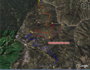
*That the family car was not parked a mile from the Black Bar Lodge (which was closed for the season but full of supplies); on his hike out, Kim would have passed the road. Since it’s apparently an unmarked turn (or signs or markings were not apparent in the snow), it’s not much of a surprise that he just kept going. (The updated and corrected version of the 3D terrain image depicting the area and James Kim’s route is at the link above and is shown below; not sure who produced it, but it’s a nice use of the online mapping tools out there).
Beyond the new details of Kim’s route, the Chron’s story also suggests local officials–particularly some in Josephine County–dropped the ball. Most damning, if true: a report that the Black Bar Lodge’s owner spotted tire tracks along the Kims’ route, told the county emergency services coordinator, and urged her to direct a thorough search of adjacent logging roads. The emergency services coordinator didn’t speak to the Chron, but there’s apparently no evidence that anyone ever followed up on the lodge owner’s tip, which came the day before James Kim set out on his attempt to hike out and three days before a local helicopter pilot, following a hunch, happened upon his wife and children.
A southern Oregon blogger, Joe Hunkins, did a fairly good job following the search and also offered some of the earliest smart speculation (caveat: that I’ve been able to find) that the Kims were lost somewhere along the route from Merlin to Gold Beach (Bear Camp Road). Eventually, his posting prompted a long and sometimes insightful discussion about James Kim’s plight and the search for him. The discussion steered me to the 3D images referenced above, and also to a short video clip (below) of the forest intersection where the Kims took their wrong turn. The clip is ghostly, ending as it does with the camera passing a series of sheriff’s department trucks parked alongside BLM Road 34-8-36 during the hunt for James Kim.
The Kim Ordeal: Wingnuts Weigh In
Two fringe posts of note:
From the left: “Did James Kim die because of the war?“
From the right: “The James Kim Story Doesn’t Add Up“
[posted with ecto]

