Lake Abert, 1990

Lake Abert, Oregon. October 1990.

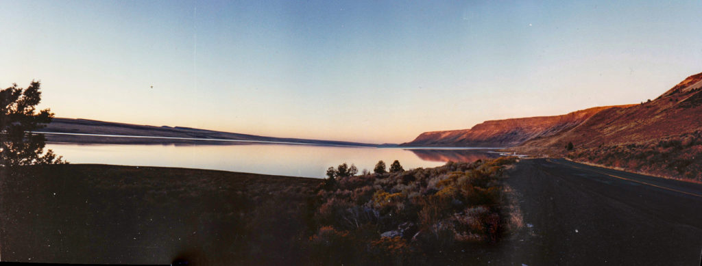
Lake Abert, above, is along U.S. 395 in southern Oregon, about 80 miles east of Klamath Falls and 75 miles north of Alturas, California. I passed by during a trip with my dad in October 1990. I remember it was a Friday evening, and we’d had a full day of traveling south from Lewiston, Idaho, with one significant misadventure along the way. We’d locked the keys in our rental car when we were about 50 miles from the nearest town. It was cold and starting to snow a little. My solution, which I’m not too sure I’d improve upon now, was to break one of the rear windows to get back in. One discovery that led to was that our Ford Taurus got about half the normal gas mileage when you drove at highway speeds with a broken-out window. The effects of increased drag, I guess. We stopped at a town along the way — John Day, maybe — and got a piece of cardboard that we taped in the window opening. That was enough of a closure that the mileage went back almost to normal for the rest of the trip.

We stopped at Lake Abert, which for a long time I believed was Lake Albert, around sunset. We had a ways to go, since the next motel was in Alturas. The light was beautiful, of course, and the way I remember the scene, it was completely still and silent. I took eight shots for a panorama with whatever little film camera I was carrying. The developed prints have been shuffled from one drawer to the next for 30 years. But in a fit of archival exploration, I grabbed them, scanned them (30 years of dust and grunge included) and panaroma-ized them in an application called Hugin (neither Lightroom nor Photoshop recognized all eight shots as part of the same scene for whatever reason).

I didn’t realize until just now, as I looked for information on the lake, that the moment we captured was in a sense a fortuitous one. In the early ’90s, Lake Abert went into a decline attributed to agricultural water diversions and climate change. Water levels have dropped; salinity levels — Lake Abert is Oregon’s only “hypersaline” saltwater lake — have risen. That’s a combination that caused a sharp drop in brine shrimp and other organisms in the lake’s waters; that in turn triggered a decline in the number of water birds visiting and nesting at the lake.

The decline has led to proposals for new environmental protections, including declaring Lake Abert “a wild and scenic river.” A quick search turned up a couple of other decent background pieces on the lake from recent years: Salinity and Water Levels Changing the Face of Lake Abert Wildlife (2018) and Oregon’s Only Saltwater Lake Is Disappearing, and Scientists Don’t Know Why (2014).

Journal of Airliner Seat Photography 2

byronnuclearplant091012.jpg

Further notes on my occasional hobby/obsession with snapping pictures while strapped into an airliner seat: The scene above shows the Byron Generating Station (a nuclear power plant) in Ogle County, Illinois, about 70 miles west of Chicago’s O’Hare International Airport. The view here was taken July 26, 2012, from American Airlines Flight 1661, to San Francisco, about 12 and a half minutes after takeoff (we lifted off the runway at 6:43 p.m. CDT, about two hours late). The view here is north/northeast. The Rock River is at the left, and the town of Byron is at the upper right, about three miles from the plant; the town of Oregon, Illinois, is just out of the frame at the lower left.

As it happens, Kate and I were driving in this area last week, and when I saw the plant’s cooling towers in the distance I started looking for a place to stop and take a picture. We found Razorville Road, which runs north-south about a mile west of the plant, and pulled off. The roadside was studded with “No Trespassing” signs, and I was careful not to stray beyond them. I half expected armed guards to show up, but none did. I got my pictures, and we drove off to another local attraction, the Black Hawk statue at Lowden State Park.

byronnuclearplant091012a.jpg

Pac 10 Football

We’ve expended exactly zero words in this space on this year’s football season, college or pro. There is a local team worthy of regular comment–or ridicule–and that’s the Oakland Raiders. But enough about them. The two teams most avidly followed under this Berkeley roof are California, of the NCAA’s Pacific 10 conference, and Chicago, a founding club of the National Football League. Both perform their gridiron labors under the sobriquet “Bears.”

We don’t lose a lot of sleep over either Bears squad. They’re just not good enough to cause that or to merit it. But emotional attachments are hard to sunder and occasionally the teams are entertaining. Cal is a more immediate experience, seeing they play a couple miles from our house, close enough that when the stadium cannon is fired to celebrate a touchdown it’s clearly audible here.

The conceit for any fan of a decent college football program is that the team they follow is on the threshold or at least capable of greatness (some people root for teams that actually are great–such as the quasi-pro squads at schools like Florida, Texas, and the University of Southern California. I don’t know have any idea what it would be like to root for such a team, though a certain infuriating smugness seems to come with that rarefied territory).

California, at any rate, is a school with a consistently decent football program, a program good enough and rich enough that its coach is a millionaire and fans enjoy a week or two every season thinking that, “Gee, this year these guys are for real.” But Cal, millionaire coach and all, is also a consistently inconsistent team, capable of spectacular performances, weird lapses and blind stupidity–sometimes on the same play. The team won its first three games this year, badly abusing a collection of overmatched squads. Then it began its conference schedule with a game against Oregon in Eugene. Cal looked helpless and scored a single field goal while the Ducks ran riot. Cal made an identical impression against USC in Berkeley: a lone field goal while the Trojans cruised up and down the field at will. Since then, freed of expectations, the Bears have had an OK season. They lost to a good Oregon State team. They beat UCLA, Washington State, Arizona State and Arizona. Today they played Stanford.

Step back a moment from the Cal particulars. The rest of the conference has been pretty interesting.

Oregon demolished Cal, then went on to smash USC, the perennial conference power. It was Oregon’s year, until they played Stanford a couple weeks ago. Stanford whipped them.

USC lost an early game to Washington–continuing a string of seasons during which it has lost a close game to a weaker conference opponent (other upsets in recent years came by way of Oregon State and Stanford). Then the Trojans seemed to get back on track by dominating California. But USC didn’t really flatten anyone else. In fact, they got steamrolled themselves by Oregon in Eugene. And last week, Stanford not only beat them but racked up more points against them than any team in history. It couldn’t have happened to a nicer bunch of guys (by which I really mean: a more entitled-seeming group of fans).

So Cal vs. Stanford. The Cardinal took down Oregon immediately after the Ducks’ big win against USC, and then it simply overpowered USC. Both Oregon and USC stomped Cal. What chance could the Bears possibly have? Naturally, the Bears beat them. Not just beat them, dominated them — the 34-28 score hid the fact Cal held the ball for nearly 40 minutes out of 60 and got 31 first downs to Stanford’s 16.

Elsewhere, Oregon came from behind to beat Arizona and keep the inside track for the conference championship and Rose Bowl berth. But to get there, they need to beat Oregon State on December 3. It’s a home game for the U of O. I’ll give the edge to the Ducks over the Beavers.

But this is the Pac 10, so don’t bet on anything.

The I-5 Trivia Files: Self-Interview

Q. So what’s the topic?

A. I was thinking about driving up Interstate 5 and all those passes you cross.

Q. Yeah?

A. It’s a flat valley drive until you get to Redding. That’s 200 miles from the front door. Then there’s some climbing and lots of twisty parts around Lake Shasta. And then you go up some more, past Dunsmuir.

Q. Dunsmuir?

A. Dunsmuir’s about 50, 55 miles north of Redding. LIttle town on the upper part of the Sacramento River. Popular place during trout season. Elevation up there is about 2,500 feet.

Q. What then?

A. Mount Shasta. You can see the mountain way down in the Valley. Once we saw it clear down by Dunnigan, which is 180 miles down the road from the peak. But when you get into the hilly country around Redding, you lose sight of the mountain until you’re much closer. And then, bang, there it is.

Q. Big.

A. Very big. Very impressive. A 14,000-foot peak standing out there pretty much by itself. Anyway, the highway goes up past the town of Mount Shasta, which sits on the eastern base of the mountain. At about 3,500 feet. Then I-5 goes up crosses Black Butte Summit. About 3,900 feet. That’s the first real pass, maybe 50 miles south of the Oregon border.

Q. Black Butte?

A. It’s a volcanic cone of some kind. Next to Mount Shasta, it’s the most remarkable sight along that part of the road.

Q. OK. You’re still going north. What’s the next pass?

A. Well, the road loses some elevation first. You go through Weed, which is mentioned in passing in “Of Mice and Men,” the Steinbeck story. It’s a place Lenny and George had to leave before they landed in the Salinas Valley, where the story takes place. Then you go through Yreka, which ought to have a bakery because it it did you’d have a good palindrome. The road goes right up after you pass Yreka, up Anderson Grade. There’s a nice view of Shasta to the south, and somebody put a dragon sculpture along the highway there. You climb up to Anderson Grade Summit. Maybe 3,100 feet.

Q. Not a big deal?

A. Well, it’s steep coming up from Yreka, and the road winds, and there are plenty of slower trucks up there, and then the road plunges down toward the Klamath River. There’s an exit right along the Klamath with a rest area. Good place to stop, though I only remember doing it once.

Q. Still in California.

A. For a little while, maybe 10-15 miles. The road goes up and down for a while, you pass a weigh station, and then you start climbing again. The last town in California is called Hilt. Milepost 796, I think. And then you’re on the Oregon border.

Q. How far from home?

A. About 320 miles. That climb that starts in California is the Siskiyou Summit climb. That’s two syllables — SISK-you.The summit is the highest point on I-5, 4,300-some feet. Doesn’t sound that high — all the well-known passes in the Sierra Nevada are in the low 7,000 to 10,000-foot range. But Siskiyou is far enough north and gets enough wet weather in the winter to make it a barrier. I know plenty of people who’ve gotten stopped there during snowstorms. Or at least a couple.

Q. How about you?

A. Never. We always had great luck driving through there in winter. The road always seemed to be dry and clear when we went through on our way up to Eugene.

Q. Where’s the road go next.

A. There’s a steep drop with a couple runaway-truck ramps down to the town of Ashland, where the Shakespeare Festival is. Elevation there is probably 1,500 or 1,800 feet. Then you’re in a valley through Medford, the big town in the region. Then you noodle around through Grants Pass before you come to the three summits.

Q. Three summits?

A. Well, you hit them one right after another. I always tried to keep the order straight. Northbound, I think you hit Sexton Mountain first. Then … Stage Road, I think. And last … Smith Hill. I think the last is the highest, about 2,000 feet. Then there’s a little break crossing a valley, and then you hit a fourth pass, Canyon Creek, which is also not very high but has a long, long descent to Canyonville and then the Seven Feathers Casino.

Q. How many times have you done this drive?

A. Over the last four or five years maybe 20, 25 times. Enough to get to know it. That’s the last named pass that I know of, Canyon Creek. Though there are rivers.

Q. That’s a different species of geographic phenomenon. Which ones?

A. Well, from the south, you’ve got the Sacramento, which you cross and recross half a dozen times from Red Bluff up to Dunsmuir. Then the Shasta, which is a tiny thing, and maybe the Little Shasta. The Klamath. Bear Creek between Ashland and Medford; has enough water running to be called a river. The Rogue. The South Umpqua and the North Umpqua. The Coast Fork of the Willamette, and the southern end of the mainstem Willamette just as you get into Eugene. Maybe other rivers. But a whole bunch of creeks, too. One name that comes to mind: Jumpoff Joe Creek, north of Grants Pass before you go up Sexton Mountain.

Q. Creek names are a whole other subject.

A. True. We’ll get to them later.

Mount Tabor

Cimg5992 1

In Portland on Monday evening, Pete took me on a favorite walk from his place in northeast Portland, up to Mount Tabor (two or maybe three facts he alleged on our stroll: Mount Tabor is an extinct volcano, and Portland is one of two cities that has an extinct volcano inside its municipal boundaries; the other is Bend, Oregon). Anyway, it was beautiful up there with the late twilight. Lots of people picknicking, walking, taking in the views; we happened upon one group sitting in a meadow, playing guitars and singing. We spotted the two guys above at a west-facing view near the summit. What got our attention was their smoking: they were seriously attending to smoking pipes. Of course, I wanted to capture smoke curling up from their inextinguishable briars. Alas, I couldn’t get an angle on my subjects that wouldn conceal my intentions. This angle was OK, though, especially after I noticed the little dog under the bench. (Below: Mount Hood, seen from the eastern crest of Mount Tabor.)

Mounthood062208

Technorati Tags: ,

Two from the Road

Road012108

As mentioned in a road-addled state earlier this week, I drove up to Eugene on Monday, then drove right back. Not that it was a world-class ironman stunt or anything, but still: 512 miles up there, 512 miles back. We were actually rolling at 9:14 a.m. (projected start: “8 o’clock at the latest”), and we pulled into Thom’s driveway near the University of Oregon at 5:37; that was with one fairly long stop (40 minutes) in Ashland gas up and then sit down and have lunch (Pangea; wraps highly recommended). I got another tank of gas in Eugene and was driving south again at 6:12 p.m. There was no traffic to speak of all the way south, but it started to rain when I got about halfway down the Sacramento Valley. It started to rain, and I started to get tired. Along the way, I experimented with some night-time windshield pictures. The one above is from southwestern Oregon, north of Glendale, Grants Pass and Medford (as the road sign indicates several times). The one below is from Interstate 80 in Vacaville, just after leaving i-505. Things were starting to look a little fractured at that point.

Road012208

Technorati Tags: , , ,

Tuesday Notes

Speaking of new neighbors: The New York Times reports that wildlife biologists from Cornell are doing a study of the apparently large and relatively new population of coyotes moving into Westchester County, just north of the city. Coyotes have an apparent taste for small dogs of the dust-mop variety: “… a Mount Pleasant couple reported that a few years ago a coyote hopped a four-foot fence, snatched their Lhasa apso and jumped back over — in plain sight of the husband. In June 2006, a Croton-on-Hudson resident, Herbert Doran, was walking his bichon frisé at night when a coyote lunged at the dog. ‘He tried to muscle me out of the way with his body to get to her,” Mr. Doran said in a phone interview. “I came down on his head with a flashlight. He was stunned for a second and then he stepped back. We had a stare-down for four or five seconds and then he took off.’ ”

Places not to get lost: Oregon ranks high on the list. Two or three weeks ago, Bay Area papers were reporting on two locals who had gone missing while on a trip to the Portland area. Investigators and family members speculated that the pair, a Jesuit priest and a longtime friend, had run off the road somewhere while touring the region. Well, it turns out the speculation was right — the missing people were found dead in a car wreck off the side of a northwestern Oregon highway. But that’s not all. It turns out that another motorist witnessed the June 8 crash, took careful note of the location, and then left the scene to find a phone and call 911; he reached dispatchers just minutes after the accident but he had no information on the potential victims’ condition and didn’t return to the scene.

After some initial confusion about which jurisdiction should respond, police arrived at the reported location. They looked around for awhile, and after about an hour called off the search. As The Oregonian reports, the families of the dead tourists are pretty unhappy: “We want to find out what skill levels and communication go on in Oregon,” said Rosemary Mulligan, [driver David] Schwartz’s sister. “The individual who called 9-1-1 was so detailed that my 16-year-old daughter could have found the car. For adults not to find it is pretty inexcusable.”

Technorati Tags:

Big-Ass Oregon Tree

Maple052707

On Thom’s block, south of the campus in Eugene, a huge sidewalk maple (at least I think it’s a maple). Somehow it hadn’t made an impression the several times we’ve been up there. The crown of the tree is big, but you can tell it’s been cut back over the years so it doesn’t overwhelm nearby houses. The trunk, though, is massive, as demonstrated here by various two- and four-legged organisms.

Maple052707BMaple052707C

Technorati Tags: ,

Big V

Eugene030307A

From atop Skinner’s Butte in the middle of Eugene, looking south across downtown. Kate and I drove up Friday to spend today with Thom–his 20th birthday. Amazingly, I don’t think we once went into dramatic retelling of “the night you were born” stories. Instead, we spent most of the daylight hours outside. It’s been rainy up here lately. We heard a woman at one of the drive-up coffee stands on Franklin Boulevard say she woke up, saw the sun, and thought it was a UFO. The sunshine and warmth lasted all day, and besides Skinner’s Butte (named after the city’s founder, Eugene Skinner), we walked along the Willamette, saw a bald eagle hunting the river, and took a short hike up a high ridge south of town. A great day for us. Too bad we don’t have more time up here–we need to head back south tomorrow. It’s always a fun trip, though.

Technorati Tags: , ,