Red Tails, Berkeley Hills Edition

hawk072012.jpg

We went for an afternoon hike up on the Seaview Trail in the Berkeley Hills. It was hot up there for the dog, but it was apparently perfect flying weather for red-tailed hawks. We saw a couple of them as we got up onto the ridge, apparently young one without the darker adult plumage. At the top of the ridge, another one appeared–that’s the picture above. And when we were lower down, returning to the car on the Quarry Trail, what appeared to me to be an adult began circling close by. The pictures aren’t National Geographic quality, but they give an idea of the intricacy of the plumage, and I love the translucence of the feathers. What beautiful birds.

Blue Gum Hill

buenavista041711.jpg

A favorite walk for years, from our place in the North Berkeley flatlands, up Vine Street, Vine Walk, La Loma Steps, to Buena Vista Avenue. That last street winds up a hill full of stands of immense eucalyptus trees (also known as blue gums in their native Australia; they’re looming in the fog in the shot above) . When I say immense, I”m guessing some are pushing 150 feet in height 15 feet in girth at their base. They’re in many cases unwanted/ I recently came across a neighborhood flyer on a street in the hills that was appealing to neighbors to get together and pay for a “once in a generation” chance to cut down some view-blocking eucalyptus trees; the opportunity came up because the house in the yard of which the trees stood had recently changed hands, and the owner was willing to have the trees felled as long as he could split the expense. The eucalyptus also make locals nervous because when they burn, they burn fiercely. There’s no stopping a fire that’s burning through the crown of a stand of these trees. I remember hearing occasional sharp reports during the Oakland Hills fire of 1991 and thinking they were gas tanks exploding only to be told by an Australian spectator that it was blue gums. Absent fire–and today is anything but fire weather–they’re beautiful.

Berkeley Cycling: A Dangerous Place, Part II

[Previous post: ‘Going to a Dangerous Place‘]

A couple weeks ago I wrote a post called Going to a Dangerous Place” about a series of stories about the death of a cyclist, Kim Flint, on South Park Drive in the Berkeley Hills. In particular, I took issue with the description of Flint as “obsessed” with a socially networked training-log site called Strava, whether his concern for attaining speed records for various road segments drove him to ride dangerously on the hazardous South Park descent, and whether his death could really be blamed on the service that Strava provides. A few days ago, a Berkeley cyclist I’ve met named Patrick Gordis offered to set me straight on some of the issues I raised. What follows are his comments on some of the issues raised by this incident. Patrick posted these as a long comment on the blog, but he gave me the OK to repost it as a separate entry (and the picture below comes from him, too; I’ll post a better version later). Here’s his post:

Dan: Thank you for your thoughtful analysis of this tragic accident. I would like to add a few more details to clarify the record. First of all, I don’t know if you came across the account of his accident as reported in the Daily Cal? Note in particular the following quotes of his partner of 19 years:

Violet Hefner, Flint’s partner of 19 years, said she is “99 percent certain he was trying to regain his lost record,” the day he was killed. Hefner said they had originally started cycling together, but she thought it was too dangerous. “He knew that I was very, very afraid of him riding on city streets,” she said. “I begged him not to.” Hefner added that once Flint joined Strava, his interest in his speed and his ride statistics became more intense. “Things really escalated once he got involved with Strava,” she said. “It became an obsession with him.” Flint holds a best time of an average of 33.9 miles per hour on the “Centennial Drive Descent” in Berkeley as well as the record for the “Skyline Boulevard Descent” in Oakland with an average of 30.4 miles per hour. Hefner said Flint had been focusing more and more on getting “king of the mountain” – the highest speed for a certain stretch of road – for downhill segments over the last two months. Hefner added that though the website fueled Flint’s urge to push himself, she didn’t blame the competitive nature of Strava for his death.

south_park_15mph_curve.jpg The Daily Cal story also seems to imply that Kim may have entered the sharp corner towards the upper section on South Park Drive where he sidewiped a passing car at close to 45 mph. Based on my own experience on that turn, I would say anything over 30 mph at the apex of the turn would be a difficult, if not impossible line to sustain without use of the entire road (even then, anything near 45 mph seems too fast for a turn of that kind – even for “Il Falco”). (Click picture for larger image.)

Furthermore, I had some private email exchanges with Kim the weekend before his death in which we discussed various Strava segments of a 95-mile ride we had taken together with one other cyclist. In particular, he analyzed for me why, in his view, he did not get the KOMs on the Palomares north side descent or the Joaquin Miller descent from Skyline to Mountain. From these email exchanges, from conversations I had with him about Strava on our rides and from observing him descending, it’s clear to me that he was very focused on obtaining Strava downhill records and attempting to reclaim any that he lost. For example, he carefully analyzed how he could enter the beginning of a Strava downhill segment with the maximum possible speed (based on different possible approaches). He concluded his analysis of our last segment down Joaquin Miller Road by noting, “Now I’ll need to plan a ride just with winning this one in mind. It’s not right to see a descent in the East Bay without SteveS or me at the top!”

Like you, I respect and admired Kim’s strong competitive spirit which (as you note) is often, on one level or another, a strong animating force in many serious or avid cyclists of various stripes. However, based on my own extensive riding and competitive bike racing experience, I don’t concur with your equation of Strava with pretty much any competitive group ride experience.

You wrote, “That having been said, the focus on Strava is misguided. The virtual competition encouraged by the site is simply another version of what happens whenever groups of fast, fit, competitive cyclists get together. They’ll often ride aggressively–on the climbs, on the flats, in sprints, and yes, on descents, too. Why? Bottom line, it’s challenging and fun.”

On group rides, a relatively less experienced cyclist like Kim would likely try to follow the wheel of a faster, more experienced rider down a technical or superfast descent. This is a valuable learning experience by which one learns how to descend fast and safely by trying to follow the best lines through turns, learning how to set up for the next turn and how fast to approach sharp curves which more seasoned riders have successfully cornered at high speed many times. On a group ride, you can learn to go faster in a controlled manner, profiting from the years long experience of other riders. When you are racing a Strava opponent, it is more analogous to some type of virtual or online/videogame opponent – a faceless entity you probably do not know at all.

When Kim analyzed for me in our email exchange his unsuccessful attempt to gain the Palomares descent KOM (Kim wrote that he was the fastest on the steep upper portion, but lost time on the flatter section lower down), he did not know that he was comparing his performance to a multiple national track and crit champion who is as close to a local cycling legend as we have in this area. In a nutshell, at least for me, that is the central danger to downhill racing on Strava. Aside from the obvious risks to innocent bystanders, Strava can set up a direct competition between someone like Kim who had been avidly cycling for about two years, mostly riding on his own or with one other rider, and pit him against someone who may have been a national champion or a professional cyclist.

Berkeley Cycling: Going to a Dangerous Place

[Update: ‘A Dangerous Place, Part II’]

The week before last, a cyclist was killed descending South Park Drive in the Berkeley Hills. News reports say the rider, Kim Flint, crossed the center line and hit the side of an uphill-bound vehicle. He was airlifted to a hospital in Walnut Creek, where he died.

Here’s the twist to the tragedy, as reported in a subsequent story carried on The Bay Citizen and in the Bay Area pages of The New York Times: Flint may have been attempting to set a speed record on the descent to maintain his first-place ranking on a site called Strava.com. Strava, like other sites, allows riders to upload data about their cycling performance and create publicly viewable online training and ride logs. Unlike other sites (that I know of), it keeps records of times for defined road segments. Until shortly after Flint’s death, there was a “King of the Mountain” ranking listed for South Park downhills.

What I find interesting about the Bay Citizen/Times article is the series of leaps it makes to more or less attribute Flint’s death to his activity on Strava. I say “interesting” because it’s from the same reporter who put together a complete, well-reasoned, and sensitive piece for the local news blog Berkeleyside then produced this second story that suggests Strava was an “obsession” for Flint, who recorded the fastest Strava time down South Park in early June. “But on June 15,” the second story says, “another rider bested his time by four seconds, prompting Mr. Flint to ride that stretch again four days later.” There’s no support in the story–statements from Flint or from his fellow riders–for the notion that Flint was “obsessed” with Strava or that his fatal ride on June 19 was driven by a hunger to reclaim his Strava record. In fact, based on the evidence available on Strava, there’s little to suggest that Flint or anyone else is particularly obsessed with the South Park descent. The site lists 71 total descents of the segment since the fall of 2007, with 34 of those this year. Flint is listed twice–once last August, and once during his “record” run in early June–before the ride on which he crashed. Just one quote from another cyclist about what sort of rider Flint was, how he handled himself on the road or on this hill, would be persuasive in helping us understand his “obsession.” The second story offers nothing; the first story includes a long quote from a friend and fellow rider who emphasized Flint was not a reckless type.

But the real point here isn’t whether someone’s sensationalizing a story by suggesting that a speed-crazed cyclist may have been driven to his death by a website that encourages dangerous behavior. No, it’s this: Cycling can be dangerous, and never is the danger more present (though perhaps not obvious) than during a steep descent. Strava or no Strava, the ride down South Park Drive demands skill and attention. Many riders, including me, have hit 50 mph on their way down. When I read that someone had been killed up there, I could imagine two or three places that could happen, including the spot where the accident occurred. All it takes is carrying a little bit too much speed into a corner, finding something in the road you weren’t expecting–some gravel or an animal, say–or a moment’s distraction, and you can be in trouble fast.

That having been said, the focus on Strava is misguided. The virtual competition encouraged by the site is simply another version of what happens whenever groups of fast, fit, competitive cyclists get together. They’ll often ride aggressively–on the climbs, on the flats, in sprints, and yes, on descents, too. Why? Bottom line, it’s challenging and fun. I remember seeing a couple of longboard skateboarders on Grizzly Peak, getting ready to go down Claremont. I followed on my bike to see how fast they’d go. I can’t really tell you, though, because my top speed, in the high 40s, wasn’t fast enough to keep them in sight. I did see the guys at the bottom. They were getting a ride back to the top to do it again. They were were doing something that was very hazardous and required a high degree of courage and ability, and they were having a blast.

None of which is to discount the tragedy of Mr. Flint’s death. Most of us who have ridden the roads hereabouts take an incident like this to heart. We can all too easily remember at least once when, whether through our own error or another’s, we’ve narrowly avoided serious injury or worse. Point is, it’s really the nature of the activity itself and the sum of all our habits, skills, and even emotions that lead us to this dangerous place, not the inducements of a Death Race website. That being the case, it’s important to ride with some discipline–this coming from someone who got stopped by the UC police for rolling through a stoplight on Friday night–and with a commitment to being safe.

Berkeley Hills: The Reward

bayview102509.jpg

A basic Berkeley bike ride: Start at my house, 120 feet above sea level. Take your favorite route up through the neighborhoods towards Spruce Street, one of the main roads into the hills (I ride up the north, purely residential end of Shattuck Avenue to Indian Rock, then to Santa Barbara, then the short, sharp climb up Northampton to Spruce). At the top of Spruce, roughly 2.2 meandering miles from home and at an elevation of about 800 feet, turn right on Grizzly Peak. The direction you’re conscious of going is up; you may not perceive until looking at a map later that you’ve been riding mostly north on Spruce and that as you climb the ridge on Grizzly Peak you’ve doubled back south. After the first quarter-mile on Grizzly Peak you get to a long stretch where the climb is pretty gentle. You plunge down past the intersection with Shasta Road, then climb again to the city limits and cross Centennial Drive where it tops out on its ascent from the UC-Berkeley campus, elevation about 1250 and about 5 miles from my front door. The road then climbs more twistily, steadily and steeply–though far from punishingly steep–for another 1.7 miles or so to the top of the road–a shade under 1700 feet.

So if you’re keeping track of all that, that’s a climb of something like 1550 vertical feet in 6.7 miles right outside the front door. Again, the way it unfolds with its long, gradual stretches is not a killer. But it’s not a bad workout, either.

When I first went up Grizzly Peak, in 1980, I think, I was stunned by the views. The road clings to the western slope of a very steep ridge, so you have a pretty much wide open view across Berkeley to the Bay and beyond. About a quarter-mile or so before the top of the road, where the pops over a last little rise before leveling out and pitching down toward toward the Claremont/Fish Ranch saddle, there’s a nice turnout with a stone wall. I used to stop there every time I went up the road to take in the view. I thought of it as my reward for working to get there. It was also a good place to take a breather. Then at some point I became more focused on getting up across the top as quickly as I could, and I didn’t stop there much anymore.

Today I did. For a minute. To see the view. To drink in the warmth of this amazing October day. To take a couple of pictures. It was a good reward.

Walking Conundrum

lbltrail083009.jpg

In a neighborhood in the hills just northeast of campus, Virginia Street climbs and twists to a dead end just above a short avenue called La Vereda Road. At the very top of Virginia, you find yourself in what appear to be a couple of private driveways. It looks like you’ve reached the top. But there’s a path with jury-rigged railings and steps, some nicely carpentered, some hand-cut into a very steep slope. Going up to the top, your way is blocked by the fence and gate above. One sign seems to invite you to go farther; another sign warning of serious federal consequences — the land on the other side belongs to the Lawrence Berkeley National Laboratory — and a heavy lock on the gate stop you in your tracks. Except for the fact someone’s going out of their way to maintain access across private property up to the gate, I’d think the gate is always locked. I’ve been up there maybe half a dozen times, have never found anyone on the street who knows what the deal is and have struck out looking online for any info. Maybe calling the lab is my next step, or maybe someone who reads this will have a key for that lock. (Below: the view from the gate, shot through my sunglass lens.)

lbltrail083009a.jpg

Former Bike Rider Reminisces

As a former bike rider, I still remember how to balance a two-wheeler and sometimes venture out into the world to remind myself what it feels like to roll along the local pavements.

This morning I had an appointment over on Solano Avenue, a couple miles from home. I rode over. Then afterward, I rode up Solano and wound my way into the hills. Just to remind myself what that uphill trudge feels like.

I got to the top of Los Angeles Avenue, which is short and no big deal though it has a semi-steep pitch at the end. I was taking it very easy and riding in my lowest low gear.

Turning uphill on Spruce, perhaps the most popular way into the hills on the north end of Berkeley, another rider appeared alongside me. He was going faster than I and was visibly fitter, too. We said hi and wished each other a good ride, and within a few seconds he was pulling away. As I got ready to turn uphill on Keith Avenue, a quiet and steepish side street, the Other Cyclist was maybe 100 feet ahead of me.

I stayed in my low gear up Keith and crossed Euclid Avenue. Then I started a sort of side-step up the ridge toward Grizzly Peak Boulevard. From Keith, which has a gentle grade east of Euclid, I turned on to Bret Harte Way, which probably has a 16 or 17 percent grade (and grade is a measure of a road’s slope: 10 percent means a 10-unit vertical change for every 100 linear units; 10 feet in 100 feet, or 10 meters in 100 meters. Given my out-of-shape linebacker physique, which my legs have to carry up these hills, I regard 10 percent as pretty steep. In Berkeley, Marin Avenue climbs into the hills with gradients of roughly 20 to 30 percent, and the steepest street I’ve heard of in town is said to be 31 percent. That’s another way of saying darn near impossible for mere mortals and former bike riders).

At each corner, I tried to turn uphill. The way it worked out, I alternated between steep eastbound pitches like Bret Harte Way and flatter south-trending pieces like Cragmont. And so it went, up Bret Harte Road (steep again, and different from B.H. Way), Keeler Avenue (flattish), Twain Avenue (steep), Sterling (gentle), Whitaker (steep), Miller (easy), and Stevenson, a short street that I knew topped out at Grizzly Peak. And that was as far up as I intended to go.

I finished the climb and turned left on Grizzly Peak. As it happened, I was about 100 feet or so in front of the guy who had just passed me down below. We waved at each other, and I called out that he could have taken the short cut, and he laughed. It was a lovely piece of symmetry in a short ride into the hills, but the neatness of the coincidence made me want to try to account for it.

So here’s some arithmetic. The corner of Keith Avenue, roughly where the Other Cyclist passed me, is at an elevation of 499 feet if online sources are to be believed. The corner where we met again is at 1,082 feet. So both of us climbed 583 feet. Now, how far did we ride in linear distance? Again using an online tool–Gmaps Pedometer, which you ought to try if you haven’t already–my ride was 1.21 miles. His: 2.47. That’s another neat coincidence: His route being twice as long and the net climb being the same, his net grade (4.5 percent) is half of mine (9.2 percent). He also had to maintain an average speed roughly double mine, which would have been no problem since I was probably poking along at about 5 mph or less when the road got steep.

So those are the numbers. Interesting, but they don’t quite sum up that moment of delight when I saw the Other Rider again.

Grisly Find in Berkeley Hills

Deerhoof120806

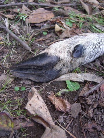
You start taking walks in the woods with a dog, and you start finding things you’d miss because you don’t, after all, have a very sharp nose. Along the Seaview Trail in the Berkeley Hills early this afternoon, Scout (a.k.a. The Dog) started nosing something lying in the weeds. When I caught up with him, I saw what he was interested in; at first glance, it looked like a little carcass tied to a couple of bloody sticks. I picked up a twig and turned it over, and saw that it was the lower part of a deer’s leg. The bloody sticks were bones that had been stripped bare by a coyote or some other hills varmint (OK–there are mountain lions up there, and they’d have an easier time dispatching a deer than a coyote would, but I didn’t think to look for any tracks; in any case, if the predator was a cat, it probably left plenty for the coyotes and other scavengers to gnaw on). Looking at it now, I’m surprised by the delicacy of it.

Technorati Tags: ,