Conor McGregor: ‘P.S. He’s a Wanker’

Conor McGregor, as seen in central Derry, May 2025.

What’s going on here?

Conor McGregor, the former cage-fighting champion and Irish whiskey entrepreneur, has become de facto leader of an Irish anti-immigrant campaign with strong echoes of the U.S. MAGA movement. Further MAGA parallels: McGregor, who lost a civil suit alleging sexual assault earlier this year, has announced he’ll run for the Irish presidency. See: “Conor McGregor, MMA fighter, alleged rapist, Ireland’s next president?

The first day of our trip to Ireland, back in late April, we ran into the aftermath of a McGregorite anti-immigrant rally in Dublin. It was staged just two days after the anniversary of the 1916 Easter Rising, which opened Irish nationalists’ initially failed, ultimately victorious effort to end British rule. Rally participants wrapped themselves, literally, in the Irish tricolor, and some chanted slogans like “Ireland for the Irish.” In Trumpian fashion, McGregor claimed a vast throng of more than 100,000 people turned out. Having been in the area where the rally was held, there ain’t no way a crowd anywhere near that size was present. Most sources estimated it at about 5,000.

The anti-immigrant gathering was followed immediately afterward by a smaller anti-racist rally and march that began in front of the General Post Office on O’Connell Street, hallowed ground in modern Irish history as the site where the Easter Rising of April 1916 began. We walked alongside the march a few blocks to its end point outside the Garden of Remembrance, dedicated to the memory “of all those who gave their lives in the cause of Irish freedom.”

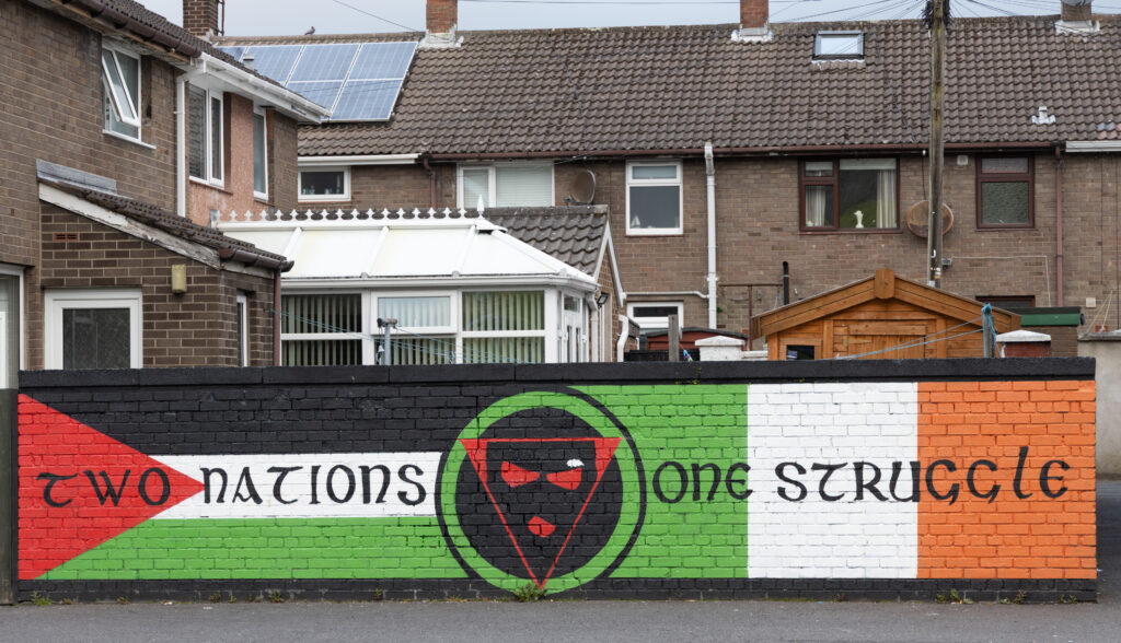
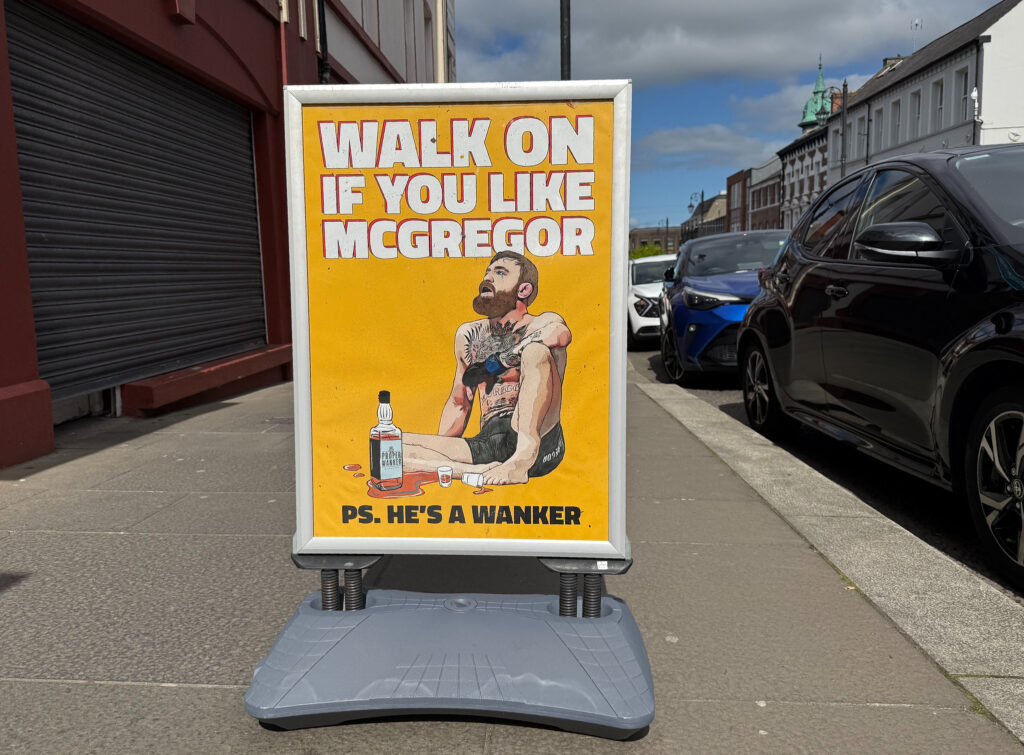
Why were we seeing a sign mocking Conor McGregor and his followers in Derry, a place where he won’t be running for anything? I think it’s because McGregor’s rhetoric touches a nerve in a place that at least outwardly is still closely linked to the struggle for Irish independence and the associated fight to achieve civil rights for the minority Catholic population.

The city is part of the six counties partitioned from the rest of Ireland in the early 1920s, which remain part of the United Kingdom as Northern Ireland. The very name of the place is contested; in United Kingdom parlance, the town is called Londonderry. It’s famously divided along sectarian and the associated political lines, Protestant/Loyalist and Catholic/Republican. In Catholic/Republican parts neighborhoods, which is mostly what we saw, the ideology expressed in street art is still strongly, even radically, Republican, and embraces other liberation causes (Palestinian nationalism, for instance) and rejects McGregor’s narrow, reactionary, anti-immigrant nationalism.

Newly painted Palestinian nationalist/Irish Republican mural in Derry’s Bogside neighborhood, May 2025.

Folly

Hussey’s Folly, Dingle Bay, County Kerry, Ireland. May 2025.

“If you ever find yourself in Dingle” sounds like the start of a joke. I don’t know what the rest of it would be, but if you do ever find yourself there, there’s a beautiful walk out from the town’s harbor, past this tower, and then to the cliffs beyond.

The date given for the tower, called Hussey’s Folly, is 1845. That was the first of Ireland’s devastating famine years. The construction was a make-work project, something devised by a local landholder for the poor and hungry to do in return for wages or food. Similar projects, often involving exhausting physical labor like road-building, were carried out all over Ireland as the country starved. Here’s a decent writeup on the “famine roads,” some of which are still used as part of the national road network: www.frrandp.com/2025/01/famine-roads.html.

Road Blog: Independence at Night

We’re staying tonight in Independence, the seat of Inyo County, along U.S. 395 near all sorts of history. Manzanar, the World War II concentration camp for Japanese-Americans, is just to the south. We’re in the middle of the Owens Valley, a place defined in modern times by the loss of its water to sharp operators from Los Angeles.

More immediately, one thing that strikes me about staying along U.S. 395 is the all-night truck traffic. It’s not a constant, relentless parade. But every few minutes or so, an eighteen-wheeler rolls through, either headed north to connect with Interstate 80 in Reno or south toward Los Angeles or maybe the desert routes to Phoenix.

Scenes from a late-night stroll through town:

Road Blog: Water to Water

Comet Tsuchinshan-ATLAS seen from Mono Lake, Eastern Sierra Nevada.

We started the day by driving down to O’Shaughnessy Dam and Hetch Hetchy Reservoir, the facilities that impound the Tuolumne River in a once pristine Sierra valley and bring water to 2.5 million people in the Bay Area (and as part of a larger system including hydroelectric facilities also supply power to some city operations in San Francisco and elsewhere). I hadn’t intended to spend much time there, but we got to walking the trail on the north side of the reservoir and pretty soon it was early afternoon.

We took our time driving over Tioga Pass and down to Lee Vining and checked into a motel and had dinner at the local Mobil gas station — it’s actually a well-known eatery and just what you need if you’ve spent a long day hiking or driving or both. Then we headed to the south shore olf Mono Lake to see whether we could sight Comet Tsuchinshan-ATLAS again. There was a nearly full moon lighting up the tufa formations along the shoreline, but yes, the comet was still clearly visible naked-eyewise and more so with any kind of camera. I didn’t bring a tripod on this trip, so I have to resort to handheld phone-camera shots. There were several guys along the lakeshore shooting the spectacle with professional gear — I imagine we’ll see some of those shots soon.

Road Blog: Up Toward Yosemite, Rim Fire Aftermath and Bonus Comet

Along the road to Hetch Hetchy, snags still stand eleven years after the Rim Fire swept through Stanislaus National Forest and parts of Yosemite National Park.

To keep it short and sweet: We’re taking a quick trip over to the Eastern Sierra. The past few years, this has involved a drive from Berkeley and a sunset stop along the road near Tioga Pass. This time we splurged and stopped at one of the lodges west of the park. We got here in time to take a quick before-dinner walk — a walk, not a hike, since it was along the road toward the long-drowned Hetch Hetchy Valley (drowned by San Francisco, but that’s another story).

Highway 120, the main road into the park from the Bay Area, goes through part of the area that burned during the Rim Fire in 2013. Much can be said about that — I happened to be up in Yosemite on a quick trip with my nephew Sean the day the fire really blew up, and we had to get home by way of Fresno. The fire burned for a very long time and at the time became the third largest fire by area in California history. It was an epic. Just eleven years later, it ranks as the state’s twelfth largest fire — nine bigger ones, including a couple about four times as large, have occurred since 2017. The point of mentioning that is that even though the Rim Fire has probably faded from most people’s memory in the wake of all the large, destructive and deadly fires that have occurred since, the evidence of the blaze is all around us in this area.

After our walk and before dinner, we went out to try to find evidence of another spectacle, Comet Tsuchinshan-ATLAS. I was really kind of blown away by it.. Reasonably bright as the dusk deepened, with a fantastically long “tail” (or so it appeared to me). Looking forward to more sightings.

Comet Tsuchinshan-ATLAS over the Tuolumne River canyon, October 14, 2024.


The Air Traveler’s Book of Happenstance

Container ship headed into Port of New York, July 1, 2024.

Among the many ways to categorize most air travelers is their choice between aisle seat and window seat. (No, I don’t think anyone really chooses a middle seat).

Aisle-seat travelers are focused on convenience. They can get up any time they want without climbing over someone or making everyone else in their row move. The freedom that convenience wins is the ability to walk to the back of the plane to use the tiny restrooms and maybe get a nice leg-stretch. Aisle-sitters see flying as a chore, something to endure.

Window-seat fliers are people who, despite suffering the many large and small inconveniences of modern air travel and getting crammed into smaller and smaller spaces on-board, still see a little adventure in the flight experience. At least that’s my take, as someone who chooses a window seat 100 percent of the time. The adventure comes in witnessing the dramatic moments of takeoff and landing and watching the country and shy reveal themselves in the hours in between.

Yes, you might nod off occasionally as you wonder which river, lake, town or highway that is sliding by miles below you. But for every instance your attention wanders, there’s another where you’re surprised by the chance appearance of something happening in the sky around you — thunderheads building up in the distance — or down there on the surface.

Maybe, after a long landing approach over the sea, on a coast far from your own, a freighter will glide beneath you amid infinitely scalloped waters, churning toward port, its bow wake creating a perfect chevroned symmetry in the last light of the evening.

Birthday Chronicles and Travelogue

Cutting to the chase: I just turned 70. To celebrate the occasion, Kate and I came to Chicago (where I’m writing this) to visit family and friends. A brief travelogue:

April 1

We flew from San Francisco to Chicago’s O’Hare airport. The first minutes of that flight take you over Oakland or Berkeley. On our April Fool’s Day trip, we had a nice view of the soon–somewhat desolate-looking Oakland Coliseum and Arena complex — former home of the Oakland Raiders and Golden State Warriors (and soon-to-be-erstwhile home of the Oakland A’s, who will decamp to Sacramento as they await construction of a stadium in their alleged eventual home in Las Vegas).

April 2

The big day. Thanks to my sister Ann and her husband Dan, I got my name in lights. We had a great time, including a trivia quiz in which I stumped the room by asking which two rivers merge to form the mighty Illinois River.

April 3

It was rainy and cold, with some intermittent snow flurries, our first three days in Chicago. I think my big activity of the day was driving my brother John to the airport for his return to Brooklyn. The picture? A local resident schools neighbors on automotive etiquette. This day also featured a visit to Pequod’s Pizza on North Clybourn.

April 4

The El, along North Franklin Street, encountered during our hunt for Italian beef.

On Thursday, the 4th, it was dry and a little warmer with occasional splashes of actual sunshine. Our son Thom was getting ready to fly back to Los Angeles. But first: We needed to find Italian beef sandwiches. First stop: Mr. Beef, on North Orleans, a place you’ll kind of know if you’ve watched “The Bear.” The restaurant was closed to accommodate film crews working on the show’s third season. Our backup spot was Al’s Beef on West Taylor Street,

April 5

On Friday, the 5th, we went down to the south suburbs to meet one of my high school writing teachers, Mort Castle, and his wife, Jane, at Aurelio’s Pizza in Homewood. Did I remember to take a picture of this Crete-Monee High School reunion? No. And neither did they. Later, Kate and I wound up at the Izaak Walton League’s Homewood Preserve. Note blue skies and evidence of direct sunlight.

April 6

On Saturday, the 6th, we drove out to the Fox River valley to see my high school German teacher and longtime friend Linda Stewart. She moved back to the town of Geneva, just up the road from her hometown of Aurora, in 2023. Also pictured: her dog, Pecan.

April 7

On Sunday, the 7th, we joined the throngs traveling to view the total solar eclipse happening the next afternoon. Our destination was Indianapolis and the home of my high school friend Dan Shepley and his wife, Paula. I had discounted the possibility that there’d. e a lot of traffic, but heading down Interstate 65 from northwestern Indiana, I discovered how naive I was. Stuck in one especially gnarly traffic jam north of the Kankakee River, we got off the interstate and made most of the trip on two lane roads heading south and east. Among the casual sightings along the way, a wind turbine being erected south of the town of Monon. We made it to Dan and Paula’s eventually.

April 8

Eclipse Day. We hung out at Paula and Dan’s all day. The sky show lived up to the hype, and the show on the ground, featuring neighbors who turned the event into a partym was good, too.

April 9

On Tuesday, the 9th, we wended our way back to Chicagoland, sticking to back roads until we suddenly realized we needed to get on the interstate (I-55 in this case) to get back in time for an online appointment Kate had.

April 10th and 11th? To be continued …

How Helper (Utah) Got Its Name, and Other Stories

Helper, Utah, and environs. (this is on the northern outskirts, and according to some maps, this was part of a hamlet, or maybe just a siding on the Denver and Rio Grande Western Railroad, called Martin at some time in the past. Maybe the locals still call it that.

In October 2022, I took a driving trip that took me to Salt Lake City, Moab, and the North Rim of the Grand Canyon, among other stops. I took U.S. 6 between Salt Lake and Moab. The route heads south and east and along one stretch descends through a striking piece of landscape called Price Canyon. At its southern end, the canyon levels off and widens into a valley, where you’ll find the town of Helper. I stopped at the outskirts, walked around a little, and took a few pictures. I posted one to Facebook, and a friend who commented asked where the name of the town came from. Never one to let the opportunity for a bit of research pass me by, here was my answer:

Hi: I took note of your comment on Facebook wondering where Helper, Utah, got its name. It turns out not to be a super-long story, unless I can turn it into one. 

The short version is this: The town started out as a small settlement at the point where a rugged piece of western topography called Price Canyon (and the Price River that flows through it) open into a little valley where Teancum Pratt, the hard-luck son of one of Utah’s Mormon pioneers, settled around 1881. About the same time as Pratt’s arrival (with his two wives and seven children; eventually he and his wives had 17 children, and he did prison time for his plural marriage), the Denver and Rio Grande Western Railroad, was laying out a route down Price Canyon. Trains traveling up the canyon — to the northwest, toward Salt Lake City — faced a long grade, about 1,700 feet in 15 miles. The railroad chose a site near Pratt’s new homestead for a station where it would position extra locomotives — “helper” engines — to enable Salt Lake-bound trains to make it up the canyon. So there it is. “Helper” became the name of the community that grew up around the station. I think it’s at least as good as “Prattville.” 

When I drove through there, what I noticed was the spectacular route through the canyon and the striking cliffs surrounding the town (along with the sign of the Balance Rock Motel). It’s almost too much to slow down enough and contemplate how the world we’re moving through was shaped. When I manage to do that, I’m always surprised and often pleased in a way by what I find. 

On the outskirts of Helper, Utah.

For instance, this guy Teancum Pratt. There seem to be lots of little capsule histories that name him in reference to Helper, but none that mention much of his personal experience. I describe him as “hard luck” after reading just a little of his journal. Among the episodes he describes in narrating his life before Helper, here’s one from his teens: 

“In my 15th year, I had the misfortune to lose half of my left foot, which was frozen off while working for George Higginson. I was driving a freight team of 2 yoke of cattle. It was winter. We made it to Salt Lake City before Christmas. Mr. Higginson sent me on to Lehi Fields with both teams of cattle. This took me all day and night, and by morning I was frozen badly. Mr. Higginson treated me badly, being fed on bread alone and not enough of that.”

And here’s a summary of events just before he dragged his clan to what would become Helper: 

“I found that my physical strength was not sufficient to endure hard labor and about the last of June, 1880, I came to the conclusion that I would go out to the frontier and take up land and either sink or swim in the attempt to maintain ourselves. So hearing of Castle Valley, I struck out and came to Price River on the 24th of July, 1880, coming down Gordon Creek from Pleasant Valley and locating at the mouth of Gordon Creek. But the neighbors were hunters, trappers, and bachelors, and soreheads and did not welcome any settlers, so I had a very tough time of it and had to leave that location and moved up to what is now Helper, at that time a lovely wilderness, and commenced anew in 1881.”

Pratt found that the land he had settled wasn’t particularly fertile, and among the various ventures he embarked upon was coal mining. Coal is still a big deal in that area of Utah — Helper is located in Carbon County, which is still a major producer (and has been involved in recent years in trying to build a coal port in Oakland). Mining drew lots of people, money and union organizing to Helper and environs.

And crime, too: In 1897, just up the canyon from Helper, Butch Cassidy and associates managed to hold up the payroll manager of one of the coal companies who had come down on the train from Salt Lake City to pay miners.

And of course, all that just barely scratches the surface of the past of this one place. What transpired here before the “settlers” wandered in? Maybe I’ll get to that. 

Conclusion of seminar. Hope all’s well with you as autumn draws on. … 

Descanso: Highway 128

Yesterday, we attended a memorial for a friend up in Davis. It was a Quaker-style remembrance, where the three dozen or so people in attendance were invited to share their stories about the departed. Most of the stories were quite surprising to me — I learned a lot about this person’s life I really had no clue about, though we’d known each other since before high school. There was a lot to process.

I was really at loose ends afterward and just felt like a drive. So we set out. I have to say here that Kate, my wife and frequent exploration partner, did the greatest thing: She didn’t ask once where we were headed. We were just going, heading west, enjoying the light of a beautiful October afternoon.

I got to know the backroads in this part of the world — the western edge of the Central Valley, the hills and mountains on the way to the coast, Yolo and Napa counties among others — while doing long-distance bike rides from the late ’80s through about 2010. So that led me toward Winters, a little valley town west of Davis, and up Highway 128 past Monticello Dam. This slice of countryside has changed a lot since my riding days. Much of it has burned at least once in the past decade, with the greatest acreage by far incinerated during a series of lightning-sparked fires in the summer of 2020. Now, huge swaths of the landscape are marked by the skeletons of burned oaks and laurels and I don’t know what else. It is stark and sobering.

A roadside memorial on Highway 128 southwest of Monticello Dam in Napa County. It reads: “Rojo. Descanza en Paz. 03 21 2021.”

A few miles past the dam and a little resort called Markley Cove, we happened across this cross. There’s a good pullout a hundred yards or so down the road, so I stopped. But it’s at a tight spot on a curve with limited visibility for both drivers and anyone foolish enough to walk on the side of the road where the cross was erected. Kate was a little dubious of me going over to photograph it; but from the front seat she had a view around the curve and said she’d honk if any cars were coming.

As it happened, after I took this shot, I could hear the sound of a car approaching … from somewhere. I didn’t hear the horn honk, so I started out into the road. Looking to my left, two or three cars were approaching. Not bearing down on me, exactly, but close enough that I felt I needed to hurry up across the road. I guess one of my ambitions in life is to not have one of these markers put up in my memory.

As to the person memorialized by this marker, here’s a snippet from the Napa Valley Register of March 21, 2021:

“A fatality was reported Sunday evening after a collision involving a motorcycle and another vehicle in the Lake Berryessa area, according to the California Highway Patrol. …

“A passenger on the motorcycle suffered minor injuries, as did the driver of the other vehicle. … The name of the motorcyclist was not immediately available.”

The CHP’s report includes a few more details: The motorcycle was headed west when it crossed the highway’s centerline and sideswiped on oncoming pickup truck. The motorcycle driver was 29 years old. It’s not lost on me that the date of the crash inscribed on the cross, March 21, was the birthday of the friend whose memorial we were attending.

As the cross in the picture says, “Descanza en paz.”

‘Desperate End of a Desperate Life’

From a short visit to Virginia City, Nevada, in The Last Summer Before the Pandemic. (Caution: the following contains explicit details of gruesome Gold Rush-era saloon violence. )

We spent a couple minutes on the main street, but when I spotted the cemeteries on the north end of town, I knew that’s where I wanted to go. The carving on this monument drew my eye — it’s exquisite but restrained. I was slow to appreciate the inverted torches at the four corners. The inverted torch, a common motif on cemetery monuments, is said to symbolize death; the flame, eternal life.

As to Major George E. Ferrend: Who was he?

Below is an account of his passing, drawn from a January 1875 number of the London Illustrated Sporting and Dramatic News. The LIS&DN, which neglects to mention that Ferrend died in Virginia City, was republishing an account carried in a newspaper called the Pall Mall Gazette. The Gazette, in turn, appears to have borrowed its story from a somewhat more detailed account published Dec. 9, 1874, the day after Ferrend’s death, in the Virginia City Territorial Enterprise. None of the stories I’ve found mention his wife, who according to the monument died two months after her husband.

Among incidents not recounted here is Ferrend’s role as a second in an 1863 duel between the editor of the Territorial Enterprise and the editor of a rival publication. The Enterprise employed Mark Twain at the time.

Here’s the story recounting Major Ferrend’s life and demise:

DESPERATE END OF A DESPERATE LIFE

The death of an Englishman in California is reported by the San Francisco Call. On the morning of the 26th ult., Major George E. Ferrend, a well-known citizen of San Francisco and famous everywhere or the Pacific coast, shot himself in the head, and thus put an end to an eventful career.

Major Ferrend was born in Lancashire and was educated at the Royal Military Academy, Woolwich. He entered the Army, but owing to trouble of some kind sold out. He then went to Buenos Ayres, where he was the leading spirit in a revolution which was successful, but was subsequently driven out of the country, and came to California.

In June 1853, he left Sacramento with a company he had raised and joined General Walker in his Nicaragua expedition. With Walker, whose chief of artillery he was, he performed prodigies of valour, particularly distinguishing himself at the battle of Rivas, where at times he was a host in himself, loading and firing a gun which sent scores of the enemy to the ground at each discharge. During the Nicaragua campaign he was wounded 13 times, but these wounds were but a few of many others, for on his body there were 48 scars of wounds received in battles and personal conflicts at various times.

He had especially one terrible personal encounter in Camptonville, California, about the year 1858 with a man of desperate character, during which he received a most serious wound with an axe. He had previously had some trouble with this man, and it was understood that when they again met, they should “meet fighting.”

The desperado shortly after came into a saloon, armed with an axe, where he saw the major pleasantly sitting in his shirt sleeves with a large knife in his hand. As the desperado advanced, the major rose and stood warily watching his foe and perfectly motionless, save that he constantly turned the wrist of the hand that held the knife, so that the weapon disagreeably flashed in the eyes of his opponent.

All of a sudden, as the desperado’s eye was fixed on the knife, the major sprang forward with the leap of a tiger and drove the knife not through the heart but through the whole body of his foe, the point projecting at his back. At the same moment, the blade point projecting the axe was buried in the small of the major’s back. Both fell on the floor together.

The desperado was dead, but the major, contrary to expectation, recovered, and was as ready as ever for fresh exploits and adventures. His numerous deeds of daring would fill a volume. He ultimately settled in San Francisco, where he accumulated a considerable amount of property.

After shooting himself in the head, he lingered for a few hours and assigned as a reason for the act he had committed that he feared he would ultimately become insane owing to one of the wounds he had received which affected his head.

The major was proprietor of a well-known saloon bearing his name, he was much esteemed by all who had the pleasure of his acquaintance, and his death has greatly shocked the whole community of San Francisco. The only wish he expressed in his last moments was that “he might die a man.” He need hardly have troubled himself on this score, for whatever may have been his errors there was certainly nothing feminine in his nature. — Pall Mall Gazette