

An American coot (Fulica americana) on the rocks next to the Oakland ferry terminal last week. I took the picture (through a window) for one reason: While these coots are omnipresent, cruising the local waterways, I have never seen one out of the water and had no idea what huge, strange feet they have: big, greenish things with prominent claws on the end of each toe. (click on the image for a bigger version and a better view of the coot feet in their full bipedal grandeur).
Meantime, Out in the Compost

Most food scraps from our kitchen go out to a compost bin next to the back fence. The bin has been out there for years and it is populated by some sort of red earthworms — not sure what species, though I see Lumbricus rubellus and Eisenia fetida are candidates. There is lots of other life, seen and unseen, out in that bin, too. Armies of mites and other insects, the occasional millipede, and bacteria, fungi, and other unseen organisms by the millions or billions. Every day or two, I go back out there and throw whatever scraps we have to offer into the bin and stir things around with a garden fork. That was the prelude to the shot above.
Which reminds me: I got worms.
One Falcon, No Salmon

I spent the weekend traipsing around western Marin County learning about the coho salmon that still return there to spawn and about their natal streams in the Lagunitas Creek watershed. Since I have never met a salmon story I didn’t like — here and here, for instance — I had a pretty good time. (Of course, the drama surrounding this endangered species this fall is the absence of any rain to boost stream flows in the watershed and prompt the fish to head upstream to spawn.)
Among the sightings on Sunday as we traipsed near the mouth of Lagunitas Creek, just outside Point Reyes Station: A peregrine falcon that appeared overhead and circled our group (about a dozen humans) for a couple of minutes before moving on to search for more likely prey. I had a long lens, borrowed from my son Thom, and managed to get one passable shot (of about a dozen or 15 frames) of the bird. If you click on the image above, the larger image makes it clear the bird had its head cocked a little, almost like it was checking us out.
So we saw one falcon and no salmon — though after the peregrine passed a big fish of some kind leaped out of the water several times. Maybe a steelhead.
Terminator

Terminator: “The boundary between the illuminated part of the Moon’s disc and the dark part is called the terminator. At the time of the quarter moon, it is essentially a straight line running north-south. At other times it will appear as a curved line.”
(Taken handheld earlier tonight with my son Thom’s nice 70-200 Canon zoom lens. Click on the image for a larger version.)
Road Blog: Hole in the Ground

A short post, since I’ve let it get so late: The next-to-last place we visited on our five-day Ice Age Floods Greatest Hits Tour was Hole in the Ground Coulee, just south of Cheney, the home of Eastern Washington University. Apparently, the area is called “Hole in the Ground” because of a 100-foot deep hole on the floor of the canyon here (one of Randy’s guidebooks says concerned locals filled it with rocks so no one would fall in).
The last stop we made, deep into the dusk, was at the site of a dry cataract not far from the site above, one of the many waterfalls that spilled flood waters south and east toward the Columbia basin when the Lake Missoula ice dams gave way far upstream.
Of course, touring the landscape created by the Big, Big Floods of Yesteryear was just part of what’s been happening the last five days. Randy and I were close during our teenage years — my shorthand for him is “my best friend from high school” — and we spent a lot of the time not filled with talk of lava flows, basalt configurations, receding cataracts, loess and loess islands, mesas, spires, potholes, craters, mima mounds, blades, benches, coulees, and the like reminiscing and catching each other up with what’s been happening in our lives.
It’s been a great five days. More pictures to come.
Road Blog: Palouse
Columbia River at Wallula Gap, shot from Twin Sisters.
Tuesday, Randy and I started out in Kennewick, Washington, made our way to the Columbia River, then south to a landmark called Twin Sisters — a sort of double volcanic spire on the east bank of the river (and in native stories, what’s left of sisters who were thwarted in their salmon fishing then turned to stone by Coyote). Part of the attraction of the Twin Sisters is what you see from there: the Wallula Gap, where the Columbia flows through an opening eroded through the Horse Heaven Hills then enlarged by the Big Floods.
From there we made our way over to the Snake River country, the town of Kahlotus and Devil’s Canyon, yet another landscape wrought by the ice age floods. We stopped in the town of Washtucna for a hot dog and a double cappuccino, then headed to Palouse Falls.
The Palouse is an extensive area of steeply rolling hills, mostly treeless, much of it planted in wheat, made up mostly of ancient wind-blown soil (or loess, pronounced “less” in approximation of its German origin) that’s as much as 200 feet deep. (That’s a shot of a recently plowed field below, looking south toward the Snake River.)
Palouse Falls is another one of those places that recounts a chapter of the flood epoch. The Palouse River flows through gorges excavated by the ice age floods and falls into a “plunge pool” dug out by the gigantic volume of water that came rushing through 15,000 years ago or so.
From the falls, we cruised back through Clarkston, Washington, and Lewiston, Idaho, to Randy’s house in the town of Orofino, population 3,000 and some, seat of Clearwater County. More geoimagery tomorrow.
Conclusion of the foregoing.

Road Blog: Potholes
Potholes, as in Potholes Coulee, part of the recently mentioned channeled scablands of eastern Washington. This was today’s main event, hiking up the one branch of the coulee — which I’ll describe as a valley about a little more than a mile and a half from west to east, surrounded on both the north and south by 300 foot rock walls. I’ll call it a valley, but it was actually an outlet for the big ice age floods that roared from northwestern Montana into the Columbia River basin.
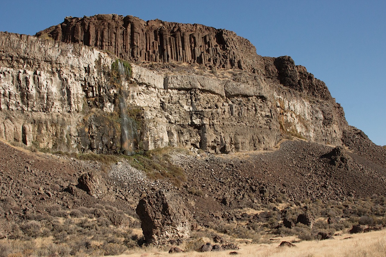
The picture above (click for a larger version) is the north wall of this part of the coulee, which had waterfalls every few hundred yards. The wall consists of multiple layers of basalt from lava flows that occurred over a span of millions of years. That columnar structure high atop the wall (it is actually called a colonnade) and signifies the lower layer of a flow and one that cooled slowly compared to the irregularly fractured section above (called entablature). The lighter rock below is basalt from an earlier flow that spent some time underwater when a lake filled part of this valley.
At least that’s what I’ve absorbed over the last few days. And here’s a more scientifically grounded partial explanation, if you’re interested.
Me? I’m done. More later.
Road Blog: Extreme Geology

That’s Washington state Highway 155, headed north from Coulee City toward Grand Coulee Dam. We got a gray, cool to cold day with a little autumn rain thrown in. The landscape is huge and surprising. To the right in this picture are basalt cliffs formed from successive lave flows over millions of years and then violently gouged out by the repeated great floods that poured through this region during the ice age. I heard an estimate somewhere today that about 520 cubic miles of water — cubic miles — came pouring across this part of eastern Washington in 48 hours. That’s a little less than the volume of Lake Michigan, which counts as a big lake in my book, discharged over a weekend. In the left of this picture in Banks Lake, a big reservoir created as part of the Bureau of Reclamation’s massive World War II era plumbing of this area. The huge mesa-like shape in the left distance is Steamboat Rock, once an island at the foot of an immense waterfall upstream. (Click the picture above for a larger image.)
Started: Moses Lake, Washington (7:15 a.m.)
McDonald’s breakfast to go
North on Washington 17 through Soap Lake
Stopped at Lenore Lake
Hiked up through canyon to Lenore Coulee and Great Blade
North on Washington 17 to Dry Falls State Park
Hiked up through notch in Umatilla Rock
Stopped at visitors center
Stopped in Coulee City; lunch at Last Stand restaurant and saloon
North on Washington 155 to Grand Coulee Dam
Stopped at Crown Point, overlooking dam and town, hiked to Candy Point
Stopped at dam visitors center
West on Washington 174 to Washington 17
South on Washington 17 to Washington 172
West of Washington 172 to U.S. 2
U.S. 2 to Wenatchee, Washington
Arrived: 7:30 p.m.
Road Blog: Scablands

The scablands–that’s what they call big pieces of eastern Washington, where I spent the day with one of my oldest friends, Randy Robinson. Roughly speaking, the scablands are the extensive rocky breaks in the rolling countryside in this part of the state. Mesas, tiered benches of basalt from ancient lava flows, gravel ridges, craters, the random distribution of huge boulders across the landscape. They’ve come to be known as the channeled scablands because of a reinterpretation of the regional geology in the 1920s that proposed that a flood of unimaginable proportions — set loose by the collapse of a colossal ice dam in western Montana, which in turn led to the sudden outflow of a huge mountain lake — scoured and sculpted the land maybe 15,000 years ago.
Anyway, that’s a summary of what Randy told me today, and we’ve got two or three or four more days of scabland hiking and sight-seeing ahead. (Where did the term scablands come from? I’m running it down — I find several references in the 1880s that apply that term to this part of Washington; I also found one possible reference from 1630s Britain that may indicate there’s an older and more general meaning of the term.
The picture above: One of our stops, a spot called Twin Lakes, west of Spokane. The challenge with this countryside is capturing something so big in any sort of meaningful way. Anyway
Outside Editing Work
So, in a flattering moment a few weeks ago, a radio reporter acquaintance, Julia Scott, asked me to edit a story she was working on, a piece tentatively titled “The Last of the Iron Lungs.” It was about one of the handful of people in the United States, a woman stricken by polio as a child in the 1950s, who was still reliant on one of the old tank respirators. (I say “flattering” because Julia’s an accomplished reporter and I think she could have had any editor she wanted.)
Like most people who grew up during the second half of the Baby Boom—after Salk’s vaccine and later Sabin’s had halted the polio epidemic—I had heard about iron lungs but had only a vague idea of what they were, how they worked, and what role they played in treating the disease or helping patients survive.
My friend Christian Warren, a science historian, helped me with my research. He sent me a couple of articles and pointed me to David Oshinsky’s “Polio: An American Story.” Here’s one thing I picked up in that reading: the story of Fred Snite Jr., infected with the polio virus in his mid-20s while traveling with his very wealthy parents in China in the 1930s. He wound up spending the rest of his life in an iron lung and may have been the first medical technology celebrity–his every move, including his return to the United States, a trip to Lourdes, his marriage and family life (he and his wife had three daughters), visits to Arlington Park racetrack outside Chicago, and his regular attendance at Notre Dame football games was recorded in newsreels and the press.
Anyway, to cut to the chase: Julia’s piece relates the story of Martha Lillard, who lives outside Oklahoma City. We edited the piece on the phone, so I never really only got a sense of how immediate and compelling Martha’s voice and Julia’s storytelling was. Until today, when I heard the finished piece, mixed by KALW’s Chris Hoff, online. Give it a listen: