A short post, since I’ve let it get so late: The next-to-last place we visited on our five-day Ice Age Floods Greatest Hits Tour was Hole in the Ground Coulee, just south of Cheney, the home of Eastern Washington University. Apparently, the area is called “Hole in the Ground” because of a 100-foot deep hole on the floor of the canyon here (one of Randy’s guidebooks says concerned locals filled it with rocks so no one would fall in).
The last stop we made, deep into the dusk, was at the site of a dry cataract not far from the site above, one of the many waterfalls that spilled flood waters south and east toward the Columbia basin when the Lake Missoula ice dams gave way far upstream.
Of course, touring the landscape created by the Big, Big Floods of Yesteryear was just part of what’s been happening the last five days. Randy and I were close during our teenage years — my shorthand for him is “my best friend from high school” — and we spent a lot of the time not filled with talk of lava flows, basalt configurations, receding cataracts, loess and loess islands, mesas, spires, potholes, craters, mima mounds, blades, benches, coulees, and the like reminiscing and catching each other up with what’s been happening in our lives.
It’s been a great five days. More pictures to come.
Columbia River at Wallula Gap, shot from Twin Sisters.
Tuesday, Randy and I started out in Kennewick, Washington, made our way to the Columbia River, then south to a landmark called Twin Sisters — a sort of double volcanic spire on the east bank of the river (and in native stories, what’s left of sisters who were thwarted in their salmon fishing then turned to stone by Coyote). Part of the attraction of the Twin Sisters is what you see from there: the Wallula Gap, where the Columbia flows through an opening eroded through the Horse Heaven Hills then enlarged by the Big Floods.
From there we made our way over to the Snake River country, the town of Kahlotus and Devil’s Canyon, yet another landscape wrought by the ice age floods. We stopped in the town of Washtucna for a hot dog and a double cappuccino, then headed to Palouse Falls.
The Palouse is an extensive area of steeply rolling hills, mostly treeless, much of it planted in wheat, made up mostly of ancient wind-blown soil (or loess, pronounced “less” in approximation of its German origin) that’s as much as 200 feet deep. (That’s a shot of a recently plowed field below, looking south toward the Snake River.)
Palouse Falls is another one of those places that recounts a chapter of the flood epoch. The Palouse River flows through gorges excavated by the ice age floods and falls into a “plunge pool” dug out by the gigantic volume of water that came rushing through 15,000 years ago or so.
From the falls, we cruised back through Clarkston, Washington, and Lewiston, Idaho, to Randy’s house in the town of Orofino, population 3,000 and some, seat of Clearwater County. More geoimagery tomorrow.
Basalt formations at Potholes Coulee, near Quincy, Washington.
Potholes, as in Potholes Coulee, part of the recently mentioned channeled scablands of eastern Washington. This was today’s main event, hiking up the one branch of the coulee — which I’ll describe as a valley about a little more than a mile and a half from west to east, surrounded on both the north and south by 300 foot rock walls. I’ll call it a valley, but it was actually an outlet for the big ice age floods that roared from northwestern Montana into the Columbia River basin.
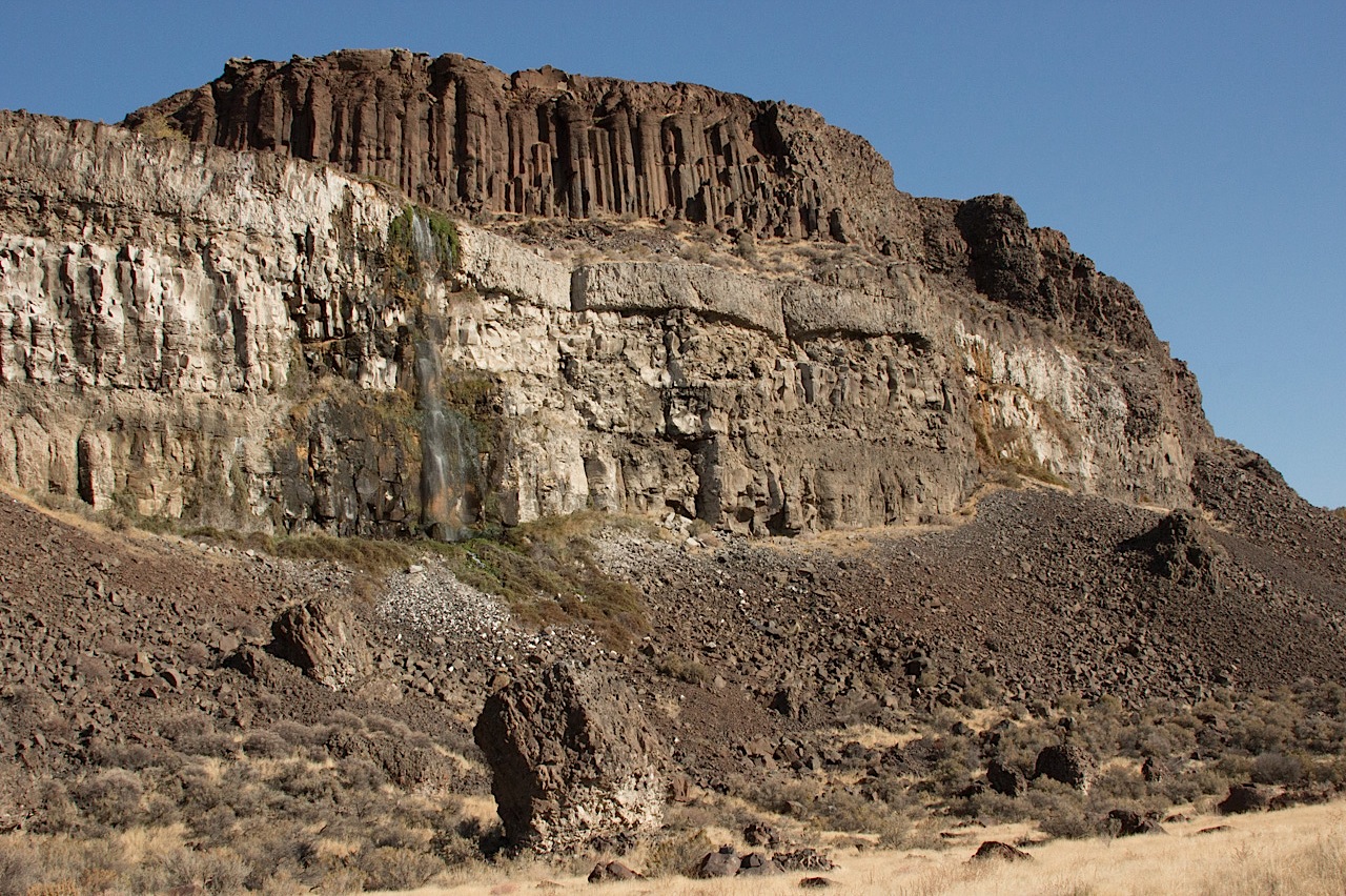
The picture above (click for a larger version) is the north wall of this part of the coulee, which had waterfalls every few hundred yards. The wall consists of multiple layers of basalt from lava flows that occurred over a span of millions of years. That columnar structure high atop the wall (it is actually called a colonnade) and signifies the lower layer of a flow and one that cooled slowly compared to the irregularly fractured section above (called entablature). The lighter rock below is basalt from an earlier flow that spent some time underwater when a lake filled part of this valley.
At least that’s what I’ve absorbed over the last few days. And here’s a more scientifically grounded partial explanation, if you’re interested.
That’s Washington state Highway 155, headed north from Coulee City toward Grand Coulee Dam. We got a gray, cool to cold day with a little autumn rain thrown in. The landscape is huge and surprising. To the right in this picture are basalt cliffs formed from successive lave flows over millions of years and then violently gouged out by the repeated great floods that poured through this region during the ice age. I heard an estimate somewhere today that about 520 cubic miles of water — cubic miles — came pouring across this part of eastern Washington in 48 hours. That’s a little less than the volume of Lake Michigan, which counts as a big lake in my book, discharged over a weekend. In the left of this picture in Banks Lake, a big reservoir created as part of the Bureau of Reclamation’s massive World War II era plumbing of this area. The huge mesa-like shape in the left distance is Steamboat Rock, once an island at the foot of an immense waterfall upstream. (Click the picture above for a larger image.)
Started: Moses Lake, Washington (7:15 a.m.)
McDonald’s breakfast to go
North on Washington 17 through Soap Lake
Stopped at Lenore Lake
Hiked up through canyon to Lenore Coulee and Great Blade
North on Washington 17 to Dry Falls State Park
Hiked up through notch in Umatilla Rock
Stopped at visitors center
Stopped in Coulee City; lunch at Last Stand restaurant and saloon
North on Washington 155 to Grand Coulee Dam
Stopped at Crown Point, overlooking dam and town, hiked to Candy Point
Stopped at dam visitors center
West on Washington 174 to Washington 17
South on Washington 17 to Washington 172
West of Washington 172 to U.S. 2
U.S. 2 to Wenatchee, Washington Arrived: 7:30 p.m.
The scablands–that’s what they call big pieces of eastern Washington, where I spent the day with one of my oldest friends, Randy Robinson. Roughly speaking, the scablands are the extensive rocky breaks in the rolling countryside in this part of the state. Mesas, tiered benches of basalt from ancient lava flows, gravel ridges, craters, the random distribution of huge boulders across the landscape. They’ve come to be known as the channeled scablands because of a reinterpretation of the regional geology in the 1920s that proposed that a flood of unimaginable proportions — set loose by the collapse of a colossal ice dam in western Montana, which in turn led to the sudden outflow of a huge mountain lake — scoured and sculpted the land maybe 15,000 years ago.
Anyway, that’s a summary of what Randy told me today, and we’ve got two or three or four more days of scabland hiking and sight-seeing ahead. (Where did the term scablands come from? I’m running it down — I find several references in the 1880s that apply that term to this part of Washington; I also found one possible reference from 1630s Britain that may indicate there’s an older and more general meaning of the term.
The picture above: One of our stops, a spot called Twin Lakes, west of Spokane. The challenge with this countryside is capturing something so big in any sort of meaningful way. Anyway
Borrowing from Michiko Kakutani in this morning’s New York Times:
“A screaming comes across the sky. It has happened before, but there is nothing to compare it to now. It is too late. The Evacuation still proceeds, but it’s all theater. … He’s afraid of the way the glass will fall–soon–it will be a spectacle: the fall of a crystal palace. But coming down in total blackout, without one glint of light, only great invisible crashing.”
We’ve spent the last several days making family visits in New Jersey and Pennsylvania: with Kate’s mom and sister in Monmouth County, N.J., with Kate’s cousin Rose north of Philadelphia. Yesterday, we made a long, looping drive back to New Jersey to the home of one of Kate’s closest high school friends, Lisa. On the way, we stopped in Scranton to visit the cemetery where Kate’s dad, Paul Edward Gallagher, is buried.
We’d visited the place, Cathedral Cemetery, just once before, in the summer of 1995. In the interim, I’ve discovered how difficult it is to find gravesites when you’re not intimately familiar with a cemetery’s layout (or even if you are). When we arrived, the cemetery office was already closed for the day, so we couldn’t get directions to the exact spot. I had a vague image of the part of the cemetery where the Gallaghers are interred, and we drove slowly around the place until I found a spot that looked right. We got out and went walking in different directions to see if we could find the site. I figured we’d never find it. But after looking for 15 or 20 minutes, Kate texted me that she’d found the place.
We went through an exercise I’ve gone through before, trying to note landmarks to remember for the next visit years hence. So: that group of five trees to the east of the site. The bee-hive shrine to the west. The prominent Mullaghy plot next to the Gallaghers. And I took pictures for a visual guide. I’ll look up the place on Google’s satellite maps and put an X on the spot. Assuming there is a next time, I’m sure I’ll feel lost again, at least for a little while.
During our search we also passed a section of the cemetery reserved for veterans’ graves. Civil War veterans and veterans of wars up through Vietnam. The largest group was from that first war, though, and a tablet had been put up with a stanza of a poem, “Bivouac of the Dead,” that reportedly appears at Arlington National Cemetery and many other burial places of Civil War soldiers. It’s by Theodore O’Hara, a Kentuckian who wrote it to honor the state’s dead in the Mexican War. He fought for the Confederacy in the Civil War (click the image below for a larger–readable–version).
I have a minor obsession with the assassinated President James A. Garfield. What drew my attention to him was one doleful fact about his passing: He lingered for 80 days after he was shot in July 1881. He succumbed to infections caused by the insistent and non-sterile probing of his most serious wound by a succession of doctors searching for a bullet. Alexander Graham Bell attempted to use a primitive medical detector to find the slug. He failed, perhaps because Garfield was lying on a newfangled metal-coil mattress. A medical historian summed up the case a few years ago: “Garfield had such a nonlethal wound. In today’s world, he would have gone home in a matter or two or three days.”
Instead, Garfield languished. Two months after he was shot, he was taken to Long Branch, New Jersey, a seaside resort filled with the rich and famous of the Gilded Age. Sort of a 19th century version of Malibu or the Hamptons. Those caring for the president are said to have thought maybe the sea air would help effect a cure. Or maybe they knew better and just wanted the president to be comfortable before the inevitable occurred.
Garfield was taken on a special train to Long Branch. His condition was so fragile that there was widespread discussion of how fast the train ought to travel on the trip from Washington to protect him from unnecessary jolts (the decision: slow. The 238-mile trip took about seven hours). Doctors thought it best that Garfield not be transferred to a horse-drawn coach from the train, so teamsters and citizen volunteers built a 3,200-foot temporary rail line from a nearby station to the 20-room Francklyn Cottage in the hamlet of Elberon, where the president was to convalesce. The line, built in less than a day, was tested by running a locomotive over the fresh tracks. Twice, the engine derailed because a curve in the line was too short, and that section of the rails had to be relaid. The third time, the tracks stayed in place, and they held up for a final test before the president’s train got there.
Garfield arrived on September 6, 1881, and he was duly installed in his seaside abode. He died on September 19.
We’ve been visiting Kate’s family, which lives in the general vicinity of Long Branch, for the last couple of days. Late this afternoon, we decided to drive over and see if we could find any trace of the Garfield story. One remnant you come across if you do some quick web research is a “tea house” that’s said to be built from some of the ties from the temporary railroad. It’s supposed to be the only building with any connection to the Garfield story that’s still standing. I saw online that the tea house resides outside the Long Branch History Museum, so we went looking for that. We more or less stumbled upon it around sunset and saw that the museum consists of the former St. James Chapel, a.k.a. Church of the Presidents, and several tiny frame structures (including the Garfield tea house) on a lot surrounded by a flimsy chain-link fence.
We also noticed that a little semi-private-looking lane nearby was named Garfield Road. We decided to take a walk up that street to see if there was anything related to the president there. What I was imagining was a plaque saying “this is the place where. …”
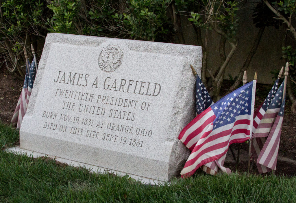
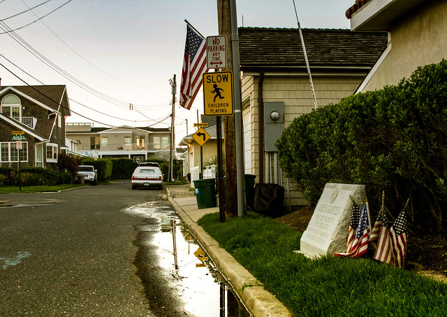
Around a corner of the lane, we encountered something just a little grander, a granite marker (pictured above) on a little patch of lawn outside someone’s shore house. It’s a wonderful scene in a way: to one side, someone’s got the garbage out for pickup. On the other, there’s a “children playing” sign. And in the middle, the simplest acknowledgment that one noted life came to an end here:
JAMES A. GARFIELD Twentieth president of the United States Born Nov. 19, 1831 at Orange, Ohio Died on this site, Sept. 19, 1881
“In 1961, as a result of a campaign begun in 1957 by 8-year-old Bruce Frankel of Asbury Park, a granite marker was erected on the site of the cottage. Mr. Frankel, a lawyer, now lives in Fort Myers, Fla. and is still an avid reader of Presidential history.”
Advantage to flying east from the western edge of the continent late in the morning: One can enjoy a leisurely morning. Coffee. Walking the dog. Getting the house a little ready for the neighbors (hi, Marie and Steve) who will be looking after things (and the dog) while we’re gone. Finishing packing.
Disadvantage to the late start: You reach your destination pretty late. And even later if your plane is delayed, the way ours was yesterday. We climbed off the jet around 11:45 or so and reached my brother’s place a little after 1 in the morning. The fatigue of the late hour was offset by the exhilaration of finding a parking space within a block of his apartment building near the Brooklyn Bridge.
The late arrival meant we were up until all hours talking with John, my sister-in-law Dawn, nephew Sean, and niece Leah. Then we had a late start this morning (or some of us did–John and Dawn were up pretty early). Eventually, Kate and I went out with Eamon and Sakura (our son and daughter-in-law) and Sean and Leah for lunch, a hike across the Brooklyn Bridge, a visit to the World Trade Center memorial, another hike up to Chinatown for dinner (with John and Dawn), then the eight of us finished with a stroll back to Brooklyn by way of the Manhattan Bridge.
Weather: beautiful. Warm and just enough humidity to remind us what that is without beating us over the head with it. Experiences: wow, were the streets crowded. I need more time to absorb the World Trade Center site. All I can say now is that the site is somber and restrained; that was a pleasant surprise.
I saw “Man on Wire” a few years ago, then again last night while we were packing for our big trip east. I love Philippe Pettit’s description of his obsession “to conquer beautiful stages.” But there’s something powerfully elegiac here, too, especially in the first three minutes or so of the clip below, a montage of the construction of the World Trade Center (the soundtrack is Michael Nyman, “Fish Beach“).