Mapping a Mosquito

Recently, the federal Centers for Disease Control and Prevention (the CDC, for short) publicized statistics and maps on where the Aedes aegypti mosquito is found across the United States; or rather, where the species has been found in monitoring going back to the mid-1990s.

Aedes aegypti is in the news because it’s been identified as the primary vector of the Zika virus. (Among things I didn’t know until I sat down to write this just now: The virus was first detected in a rhesus monkey in Uganda in 1947; the first human case was reported, again in Uganda, in 1952, and the first major outbreak was recorded in 2007 on the Pacific island of Yap, about 1,200 miles east-southeast of Manila (or 4,300 miles west-southwest of Honolulu, if you want to get all America-centric; it is a very big ocean out there).

But back to the Zika and the data the CDC put out. The statistics, compiled by a team of researchers from the CDC and Colorado State University, showed that Aedes aegypti had been found in 13 of California’s 58 counties since 1996 (in fact, all the reports appear to be from 2001 or later). In most cases, the mosquito has been found in just one or two or three years. In one case — Los Angeles County — Aedes aegypti has turned up in nine years since 2001, including every year from 2011 through 2015.

Anyway. Why was I paying attention to this? A colleague at work wanted to make a more informative map than those published along with the Oxford Journal of Medical Entomology article that carried the CDC data. I sort of pointed her to what she’d need to do, and another staffer helped her make a finished version.

Me? I started noodling around and came up with the very slightly refined map above.

Of course, looking more closely at what the CDC scientists had to say, I see there’s another mosquito I should be mapping, too: Aedes albopictus. As The Atlantic reported in May, scientists in Mexico recently detected the Zika virus in this second species.

Has it been found in California? Yes. According to the CDC researchers’ data, Aedes albopictus has been found in eight counties since 2001. In rough south to north order, they’re San Diego, Orange, Los Angeles, San Bernardino, Los Angeles, Kern, Santa Clara, San Mateo and San Joaquin. Notable: This mosquito was found in Kern, L.A., Orange, San Diego and San Bernardino counties last year; it hasn’t been detected in the more northerly counties since 2003. (The California Department of Public Health has published a map, which is says is updated weekly, of Aedes aegypti and Aedes albopictus detection sites from 2011 through this year.)

Maybe I’ll do a map with layers so we can see both species. That’s a project for another day, though.
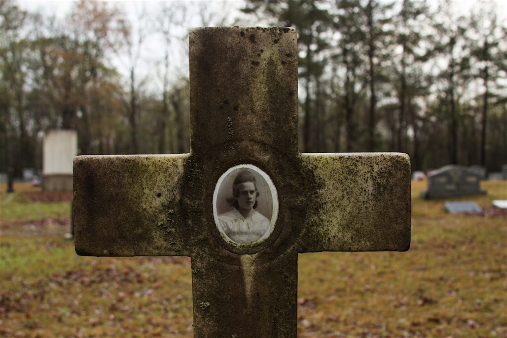
Road Blog: Battlefield Cemetery

Jewell Smith, 1904-1918, buried in the Shiloh Church cemetery, part of the Shiloh battlefield.

Kate and I flew to Nashville Wednesday so that she could attend a national conference of science teachers and so that I could tag along. There would be plenty to do in Tennessee’s state capital, but as soon as I thought about coming out here I had only one destination on my list: Shiloh.

For you who have been poring over your James McPherson or Shelby Foote or who binge on Ken Burns, you know that Shiloh was one of the principal battles of the Civil War. More than that, its 23,000 casualties — the dead, the wounded, the captured and missing — signaled that the war had the potential to be very long and very costly.

I have visited other Civil War sites: Gettysburg, Antietam, the little house where Stonewall Jackson died after Chancellorsville, and others. But this visit is different somehow. My interest has evolved. I’m still interested in the ebb and flow of battle and who did what where, and I’m still curious about what could move human beings to endure and inflict the cruelty that typified the Civil War battlefield.

What’s changed for me is that the war has lost that quality of right, of honor, of transformation and finality that it had for me when I first encountered Civil War stories and when I first visited a battlefield when I was 17. Historians have long since re-evaluated the war in light of the South’s postwar racial code and enduring political power; in light of the North’s antebellum economic dependence on slavery and on Northern whites’ widespread rejection of the notion of racial equality.

So now the war is something different to the world, and it’s something different for me as well, part of a process that’s still being played out. It’s an interesting frame of mind to bring to a place dedicated to remembering the terrors and accidents of a single confrontation in the war.

I got to the battlefield on Thursday, late in the afternoon, just as a very heavy downpour began. I spent at least a half hour in my rented car down by the side of the Tennessee River, at the site of the landing that the Union commander, U.S. Grant, used to get to the battlefield after his army was surprised by a Confederate army on April 6, 1862. I wasn’t channeling thoughts about what it must have been like on that day; I was just listening to the din of the rain beating on the car (a rented Jeep Patriot if you’re hungry for details).

Eventually, I drove up to the battlefield headquarters, then strolled through the national cemetery where most of the Northern dead (and some from the South) were interred. I took some pictures, but felt that in some way I wasn’t connecting with the place. It started to rain again, so I left and started a drive around the battlefield. Hardly anyone was around.

I happened across the site of the church from which the battle took its name. I was surprised to find that there is a working church there — built in fits and starts from the 1920s through the 1950s, as well as a cemetery that apparently goes to the founding of the original church in 1851.

What caught my attention first was the fresh decorations on many graves. When I stopped and looked, I found many fairly recent burials. In fact, a former governor of Tennessee, Ray Blanton, was buried there in 1996.

But a more modest grave, one of those closest to the road, caught my attention: Jewell Smith. Born Sept. 10, 1904. Died Oct. 10, 1918. At first, I didn’t notice her photograph, a very serious portrait, embedded and well preserved in the headstone.

What happened to her? No real idea. But her date of death suggests something to me: the great influenza pandemic was sweeping the United States in the autumn of 1918.

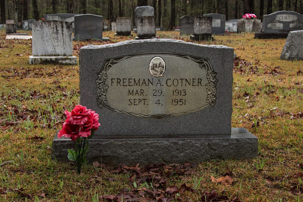
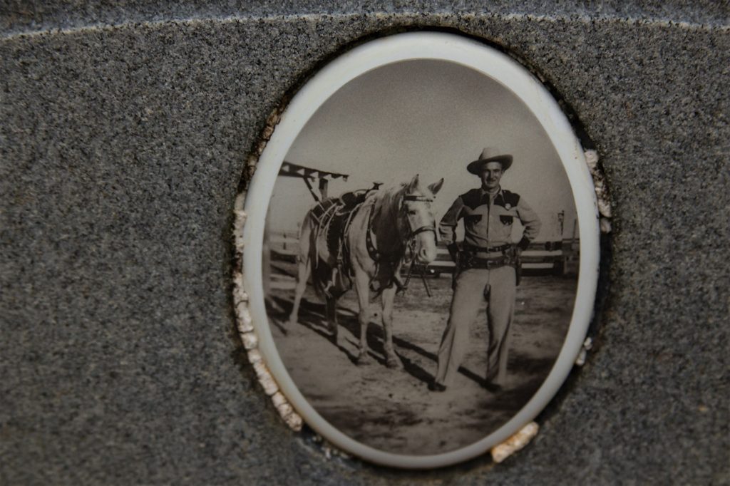
Nearby was another headstone with a photograph: Freeman A. Cotner, died in 1951 at age 38. The portrait is striking because he’s wearing a uniform of some kind, maybe with a badge, definitely with a gunbelt. Oh, and there’s the horse.

Cotner was killed in a highway crash near Fayette, Mississippi, along with his apparently sometimes-estranged wife, Mary Sue Tawwater Cotner. They either ran into the back of or head on into a large truck on U.S. 61. Their daughter, Linda Elois, was with them in the car and survived. Of note: Cotner’s mother-in-law held a separate funeral for his wife, who was not buried with him.

The grave of Freeman A. Cotner, 1913-1951, buried in the Shiloh Church cemetery.

An Eye on the Eye of the Storm

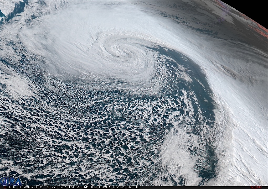
Himawari satellite image of an intense storm in the northern Pacific, March 26, 2016.

A few weeks ago, I downloaded a Chrome browser extension that, when you open a new tab, shows a current (or at least very recent) view of the full disk of the Earth as captured by Japan’s geostationary Himawari 8 weather satellite. Himawari produces high-resolution images of the Earth — the kind you can lose yourself in for hours if that’s the kind of thing you like.

Anyway, I noticed last Friday and Saturday that the full-disk image was showing a huge storm someplace in the northeastern Pacific. I wondered whether I could find a better view of the images online, and sure enough, NOAA’s Regional and Mesoscale Meteorology Branch (RAMMB to its friends), which inventories a lot of satellite images, features a Himawari Loop of the Day.

The loop for Saturday, March 26, was titled “Intense Low in the North Pacific.” Hit that link and it takes you to a movie — you need to have a little patience for the download — of the storm I was seeing in the full-disk picture. The image above is a frame from the movie.

It’s extraordinary. Or maybe everything on Earth is extraordinary if you have a chance to sit back and watch it for a while.(One note on the movie: A shadow crosses toward the end: that’s night falling as the Earth rotates. But the surface details are still visible because of GeoColor, a system that blends visible (daytime) and infrared (nighttime) imagery. GeoColor is also responsible for the reddish appearance of cloud tops in the nighttime images.)

Below is what the storm looked like on a conventional surface weather map: a sprawling, intense system with sustained winds over 60 mph forecast to occur 500 miles and more to the south and southwest of its center. The storm was producing monstrous waves, too, with seas as high 34 feet.

stormchart

2016, and I’m Thrilled to Be Here …

Science Friday filled its New Year’s Day show with some greatest hits segments, including an excerpt of an interview that Ira Flatow did with filmmaker Werner Herzog, novelist Cormac McCarthy and physicist Lawrence Krauss in 2011. It’s an absorbing 21 minutes, and I’ll have to go back now and listen to the longer version.

At one point, Herzog made an observation about the transience of human life on Earth: “It’s quite evident that human beings, as a species, will vanish and fairly quickly. When I say quickly, maybe in two or three thousand years, maybe 30,000 years, maybe 300,000, but not much more, because we are much more vulnerable than other species, despite a certain amount of intelligence. It doesn’t make me nervous that fairly soon we’ll have a planet which doesn’t contain human beings.”

Herzog explains that while it’s a possibility humanity could self-destruct, he’s really thinking more about “events … which would instantly wipe us out.”

You know — events like the Dinopocalypse.

Krauss readily agrees that a catastrophe is “likely to happen. That will inevitably happen anyway.” He adds that one of the rosier scenarios he sees for our kind is that we’ll eventually be superseded by our own creations — the computers.

Then he offers this takeaway:

“So I think, you know, we may disappear as a species just because we become irrelevant, as well as being destroyed. But I don’t think that’s a bad thing. That’s just – that may be the future. . . . We shouldn’t be depressed if we disappear. We should be thrilled that we’re here right now. . . . That just means we should make the most of our brief moment in the sun.”

Coffee Stars (or Are They Flowers?): The Sequel

coffeeflower150917.jpg

Here we are: It was midday Thursday in the middle of a week off, and I was still looking to make a mark on the world. While idly pondering what that mark might be, I behold the very end of my morning coffee, resting cold at the bottom of a mug. I wonder for the one hundredth time why the half-and-half in the cooling coffee settles into flowerlike or starlike patterns. (Actually, it’s a little alarming to me to read one of my past speculations on this topic; my thinking on the question doesn’t really seem to have evolved at all, and I wonder whether that might be emblematic in some way of being sort of stuck in some kind of barren intellectual loop. On the other hand, coffee stars are kind of interesting.)

As in earlier musings, I more than half-expect that someone research chemist somewhere can explain this. Now I will go in search.

Non-Natives in California: Snails and Other Species

snail150916a.jpg

It’s September, and just about time for the chrysanthemums we’ve been nursing through the summer with buckets of dishwater to enjoy their autumn moment. Looking at the hundreds or thousands of unfolding buds this morning, I noticed a familiar garden visitor: Cornu aspersum, also known as the brown snail, garden snail, brown garden snail, European garden snail, or European brown garden snail (in French, its common name is apparently petit-gris, or little gray). Some of the snails were young, smaller than the just-opening buds they’re presumably feeding on.

The University of California’s Division of Agriculture and Natural Resources reports there are about 280 species of snails and slugs here in the Golden State, of which 242 are believed to be natives. Cornu aspersum (formerly Helix aspersa) is one of the many non-native species, including eucalyptus, striped bass and Homo sapiens, that make California what it is today.

C. aspersum is native to the western Mediterranean, probably originating in North Africa and migrating millions of years ago into Europe. Thanks to much more recent human genius and/or carelessness, the snail is reportedly now at home on every continent except that very cold one well to the south of us.

How did this land mollusk come to California? I remember hearing when I had newly introduced myself into this bioregion that they were the same species as one served to gastrophiles as escargot. In fact, I was told that Bay Area locals had been known to capture snails, feed them cornmeal to cleanse their digestive systems of whatever vile material they might have been eating, then consume them. I can’t say I’ve ever met someone who claims to have done this themselves.

The April 27, 1900, number of the journal Science includes an article titled “Exotic Mollusca in California,” by Robert Edwards Carter Stearns of Los Angeles. Stearns related a very specific genesis story for the European snails in California:

“This species was intentionally introduced or ‘planted’ in Calfornia over 40 years ago by Mr. A. Delmas, of San José, Santa Clara county, who brought the stock from France and turned it out among the vineyards on the west bank of the Guadalupe, a small river that flows northerly through Santa Clara Valley and empties into the southerly end of San Francisco bay near Alviso. The soil where the snails were placed is a rich sandy loam and the place well shaded. When the summer heats reach the maximum, the Helices descend into the ground several feet, hiding in the cracks that form, as the ground dries, and the gopher-holes also furnish cool retreats and protection. The region above named is one of exceeding fertility. It was settled by a few French families. The introduction of H. asperse by Mr. Delmas was made for edible purposes, or in common parlance ‘with an eye to the pot.’ Mrs. Bush, of the Normal School in San José, informs me that the snails have thriven, and have extended their territory from the starting point on the west bank of the stream to the easterly side, and have multiplied to such an extent, that in some instances they are troublesome in the gardens.”

Stearns also reported Delmas had planted the snails in San Francisco, where they did not do well at first, and Los Angeles, where they apparently thrived. By 1900, it had taken hold in other locations.

“A. Delmas,” it turns out, was Antoine Delmas, a French émigré who had arrived in California in 1849. He established a nursery and vineyards in the Santa Clara Valley and is credited in “A Companion to California Wine” with being the first to import French wine-grape vines, including merlot and cabernet, into the state. Another claim for Delmas: that he brought an obscure varietal to California that became known as zinfandel.

Between the grapes, the wine and the snails, that’s a big mark for one man to have made on this place.

Rough Fire: From 26 Acres to 138,000-Plus

roughfire150914a.jpg

The Rough Fire has been burning in the Sierra National Forest and Kings Canyon National Park, east of Fresno, for six weeks now. It’s burned more than 138,000 acres, the biggest fire in California in — well, in just two years, when the Rim Fire burned more than a quarter-million acres in and adjacent to Yosemite National Park. The Rim Fire is No. 3 on Cal Fire’s list of the state’s biggest wildfires; the Rough Fire is currently No. 16, having moved ahead of last year’s Happy Camp Fire, which is still smoldering in the forests of Siskiyou County.

Among the many maps prepared during the course of a campaign to contain and control a wildfire are progression maps — sort of a historical chart of how a fire has spread over time. Above is the current progression map for the Rough Fire, current through Saturday, September 12 — click the image for a much larger version or download the super large, 10472×8092-pixel version on Inciweb).

What it shows, in a nutshell, is how the fire grew from a modest, lightning-caused incident that grew relatively slowly during the first week to the monster it has become. Weather has helped it gallop through the canyons and ridges near the Kings River, of course. But the common denominator in all our big fires this year is drought: four years of extraordinarily dry conditions have turned California into a landscape that’s even more ready than usual to burn.

Valley Fire Video: Anderson Springs Road After and Before

The video above has been picked up everywhere, I think, as a first-person view of the Valley Fire as it roared through southern Lake County on Saturday evening. It was recorded by a resident of the Anderson Springs community northwest of Middletown, and all I can tell you about timing is that it’s after dark — so sometime after 7:45 p.m. or so. At about the 50-second mark in the video, the driver goes through a gate and you can make out the words “Anderson Springs” (in reverse). Not being sufficiently employed in more productive activities (I’m taking the week off from work, where I often do the same thing I’m doing right here), I checked to see if I could find Anderson Springs Road, and the gate, on Google Street View.

The image below is a screen shot of the gate and environs in happier times — June 2012, to be more exact (the gate had been erected sometime between a 2007 Street View sweep and the 2012 image).

One thing that’s clear looking at the entire video — it’s just under two minutes, total — is that most of the many homes along the road burned. The video shows one property after another in flames, and upon reaching the corner of Highway 175, just past the gate, a voice says, “Holy fucking shit” upon seeing a large home (visible in the Street View) images that’s being consumed by fire. Here’s the Street View link to the scene below

Screenshot 2015-09-14 12.18.35.png