Well, It was actually 28 years ago today, a rainy Sunday afternoon in the Berkeley Hills. Kate and I got married at the preschool where she was working at the time — that’s why the alphabet is on the wall. My mom and dad and my son Eamon were there and a bunch of our best friends: Trapper Byrne, at the left edge of the picture here, worked with Kate and I at the Daily Cal (he’s still going, now as deputy metro editor, I think, at the San Francisco Chronicle). Ursula Stehle is next to him, a close friend since the time our older kids were born; her husband, Larry HIckey, did a reading during our brief ceremony. Beyond Ursula is Bruce Hilton, a news desk colleague of mine from The San Francisco Examiner who was also an ordained Methodist minister and who agreed to officiate once he was satisfied Kate and I were serious about the adventure we were undertaking. Outside the frame of the picture and not yet mentioned were Bill Joyce, whom we had gotten to know through Larry and Ursula; Robin Woods and Jim Tronoff, who have long since decamped to Ripon, Wisconsin; Trapper’s wife, Judy Wong; George Paolini and Jane Paulsen, newspaper friends of mine from Alameda who now live in Carmel or someplace south and west of here; and Vicki and Ross Carlton and their daughter Cedar, who hosted our celebration (it was Vicki’s preschool). It’s been too long since I’ve seen most of these folks.
At the moment the picture was taken, we were singing a funny song that Bill had written for the occasion to the tune of the Irish song “Haul Away, Joe.” I don’t have the lyrics at hand, but it was about me losing my independence. Or something like that. I still have the jacket I wore that day. It’s a tight fit, and I haven’t worn it in years. But the typewritten vows I read that day are still inside the left inside pocket, just where they were that day, not so long ago or far away.
Most food scraps from our kitchen go out to a compost bin next to the back fence. The bin has been out there for years and it is populated by some sort of red earthworms — not sure what species, though I see Lumbricus rubellus and Eisenia fetida are candidates. There is lots of other life, seen and unseen, out in that bin, too. Armies of mites and other insects, the occasional millipede, and bacteria, fungi, and other unseen organisms by the millions or billions. Every day or two, I go back out there and throw whatever scraps we have to offer into the bin and stir things around with a garden fork. That was the prelude to the shot above.
Since I’ve been doing the radio thing — actually doing some writing and reporting for the air — I’ve gotten in the habit of recording stuff I hear out there in the world.
Since I got a really capable smartphone a couple years ago, I’ve come to realize what cool little field recorders they can be.
And since I ride public transit (mostly BART) a lot, I’ve long thought about the idiosyncrasies of some of the train operators as expressed in their announcements. The guy who repeats the name of the train and station about six times at every stop. The woman who lectures riders about what station they need to transfer at (I haven’t gotten her recorded yet). The super-happy and the overly dour operators and the ones you can never really understand.
Anyway, I just had a prompt to put together some audio I’ve been gathering over the last few months. It’s not a truly finished radio piece or anything, but it’s got some fun moments in it. Enjoy.
I spent the weekend traipsing around western Marin County learning about the coho salmon that still return there to spawn and about their natal streams in the Lagunitas Creek watershed. Since I have never met a salmon story I didn’t like — here and here, for instance — I had a pretty good time. (Of course, the drama surrounding this endangered species this fall is the absence of any rain to boost stream flows in the watershed and prompt the fish to head upstream to spawn.)
Among the sightings on Sunday as we traipsed near the mouth of Lagunitas Creek, just outside Point Reyes Station: A peregrine falcon that appeared overhead and circled our group (about a dozen humans) for a couple of minutes before moving on to search for more likely prey. I had a long lens, borrowed from my son Thom, and managed to get one passable shot (of about a dozen or 15 frames) of the bird. If you click on the image above, the larger image makes it clear the bird had its head cocked a little, almost like it was checking us out.
So we saw one falcon and no salmon — though after the peregrine passed a big fish of some kind leaped out of the water several times. Maybe a steelhead.
Terminator: “The boundary between the illuminated part of the Moon’s disc and the dark part is called the terminator. At the time of the quarter moon, it is essentially a straight line running north-south. At other times it will appear as a curved line.”
(Taken handheld earlier tonight with my son Thom’s nice 70-200 Canon zoom lens. Click on the image for a larger version.)
Another slice of the Great Scablands Tour of 2013 (yes, I’m back home now, sorting through the pile of pictures indiscriminately shot over the five days poring over landscapes). On the third day of the eastern Washington trip, we started in Wenatchee, took a long hike in Potholes Coulee, then headed to the tri-cities of Richland, Pasco, and Kennewick. Before sunset, we stopped at the “Wild Horses” sculpture along Interstate 90, just across the Columbia River from the town of Vantage.
I remembered the spot from driving through here in 2011 with Eamon and Sakura: a string of metal horses dancing along the skyline on a bluff just east of the highway. We had pulled into the parking lot but didn’t have time to stop and hike up to the sculpture. My trip with Randy, though, was more about taking the time to do that (though as always I was a little worried I was holding us up through my repeated insistence on stopping to snap grain elevators, rocks, road cuts, plowed fields, riverscapes, wind turbines, declining small-town Main Streets, and whatever else the terrain offered up).
So we hiked up the steep trail from the parking lot, took some pictures, then hiked to an even higher ridge where we could see how the how the rolling Palouse country came to an abrupt stop as it encountered the flood-sculpted course of the Columbia. Up close, the horses are even more striking than they are from below. The installation is actually called “Grandfather Cuts Loose the Ponies” and is a conception of a Native American creation story by Washington state sculptor David Govedare:
“Creatures of this planet, behold, a Great Basket! I send this basket, bearing the gift of life, to all corners of the universe. Now take these ponies, I am cutting them loose. They will inspire a Spirit of free will. They will be a companion for work and play on this planet. This is a way for you to see how all life depends on all other life. This basket is my heart. You are at one with me. Eagle of the sky, we look to you for vision. Salmon of the water, we look to you for life-giving sustenance. Deer of the land, you provide a bountiful tranquility for our Mother Earth.
“From the center of my Basket burns the fire of our collective souls. Humans, you are responsible. You have the power of reasoning and the gift of free will. Use them wisely. Always be aware of the limitless nature of this ever expanding universe. Let us live to inspire each other.”
A 2008 story in the Seattle Times (“All the pretty horses of Vantage are only half done“) explains that Govedare has been trying for years to raise funds for the Great Basket portion of his installation. Aside from the cost–$350,000–Govedare has encountered skepticism from those who feel the proposed “basket” resembles a giant satellite dish a little too closely.
One other thing to note here: The graffiti. As you’ll see in the slideshow below, lots of visitors have given free rein to their urge to scrawl and doodle. Randy expressed disgust at this and at some level, yeah, it would be nice if people could refrain from leaving their marks. On the other hand, I’m reminded of the multitudes who’ve done the same thing on natural features across the West and the rest of the world–people just have to let you know they were there. (Although sometimes you wonder what’s going on in their heads. Case in point: the two Korean exchange students who were busted after scratching their names into Inscription Rock at New Mexico’s El Morro National Monument. There’s something ironic there, in that the rock has been described as “the sandstone bluff that is the birthplace of graffiti in America.” People have been doodling and scrawling there since long before the first European colonists passed by. As the students found out, now it’s historic, and off-limits to the casual graffitist.)
A short post, since I’ve let it get so late: The next-to-last place we visited on our five-day Ice Age Floods Greatest Hits Tour was Hole in the Ground Coulee, just south of Cheney, the home of Eastern Washington University. Apparently, the area is called “Hole in the Ground” because of a 100-foot deep hole on the floor of the canyon here (one of Randy’s guidebooks says concerned locals filled it with rocks so no one would fall in).
The last stop we made, deep into the dusk, was at the site of a dry cataract not far from the site above, one of the many waterfalls that spilled flood waters south and east toward the Columbia basin when the Lake Missoula ice dams gave way far upstream.
Of course, touring the landscape created by the Big, Big Floods of Yesteryear was just part of what’s been happening the last five days. Randy and I were close during our teenage years — my shorthand for him is “my best friend from high school” — and we spent a lot of the time not filled with talk of lava flows, basalt configurations, receding cataracts, loess and loess islands, mesas, spires, potholes, craters, mima mounds, blades, benches, coulees, and the like reminiscing and catching each other up with what’s been happening in our lives.
It’s been a great five days. More pictures to come.
Columbia River at Wallula Gap, shot from Twin Sisters.
Tuesday, Randy and I started out in Kennewick, Washington, made our way to the Columbia River, then south to a landmark called Twin Sisters — a sort of double volcanic spire on the east bank of the river (and in native stories, what’s left of sisters who were thwarted in their salmon fishing then turned to stone by Coyote). Part of the attraction of the Twin Sisters is what you see from there: the Wallula Gap, where the Columbia flows through an opening eroded through the Horse Heaven Hills then enlarged by the Big Floods.
From there we made our way over to the Snake River country, the town of Kahlotus and Devil’s Canyon, yet another landscape wrought by the ice age floods. We stopped in the town of Washtucna for a hot dog and a double cappuccino, then headed to Palouse Falls.
The Palouse is an extensive area of steeply rolling hills, mostly treeless, much of it planted in wheat, made up mostly of ancient wind-blown soil (or loess, pronounced “less” in approximation of its German origin) that’s as much as 200 feet deep. (That’s a shot of a recently plowed field below, looking south toward the Snake River.)
Palouse Falls is another one of those places that recounts a chapter of the flood epoch. The Palouse River flows through gorges excavated by the ice age floods and falls into a “plunge pool” dug out by the gigantic volume of water that came rushing through 15,000 years ago or so.
From the falls, we cruised back through Clarkston, Washington, and Lewiston, Idaho, to Randy’s house in the town of Orofino, population 3,000 and some, seat of Clearwater County. More geoimagery tomorrow.
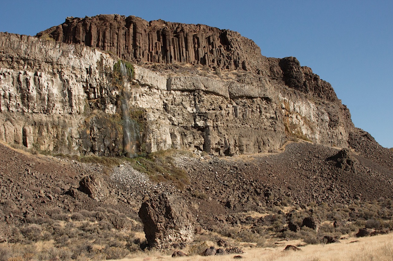
Basalt formations at Potholes Coulee, near Quincy, Washington.
Potholes, as in Potholes Coulee, part of the recently mentioned channeled scablands of eastern Washington. This was today’s main event, hiking up the one branch of the coulee — which I’ll describe as a valley about a little more than a mile and a half from west to east, surrounded on both the north and south by 300 foot rock walls. I’ll call it a valley, but it was actually an outlet for the big ice age floods that roared from northwestern Montana into the Columbia River basin.
The picture above (click for a larger version) is the north wall of this part of the coulee, which had waterfalls every few hundred yards. The wall consists of multiple layers of basalt from lava flows that occurred over a span of millions of years. That columnar structure high atop the wall (it is actually called a colonnade) and signifies the lower layer of a flow and one that cooled slowly compared to the irregularly fractured section above (called entablature). The lighter rock below is basalt from an earlier flow that spent some time underwater when a lake filled part of this valley.
At least that’s what I’ve absorbed over the last few days. And here’s a more scientifically grounded partial explanation, if you’re interested.
That’s Washington state Highway 155, headed north from Coulee City toward Grand Coulee Dam. We got a gray, cool to cold day with a little autumn rain thrown in. The landscape is huge and surprising. To the right in this picture are basalt cliffs formed from successive lave flows over millions of years and then violently gouged out by the repeated great floods that poured through this region during the ice age. I heard an estimate somewhere today that about 520 cubic miles of water — cubic miles — came pouring across this part of eastern Washington in 48 hours. That’s a little less than the volume of Lake Michigan, which counts as a big lake in my book, discharged over a weekend. In the left of this picture in Banks Lake, a big reservoir created as part of the Bureau of Reclamation’s massive World War II era plumbing of this area. The huge mesa-like shape in the left distance is Steamboat Rock, once an island at the foot of an immense waterfall upstream. (Click the picture above for a larger image.)
Started: Moses Lake, Washington (7:15 a.m.)
McDonald’s breakfast to go
North on Washington 17 through Soap Lake
Stopped at Lenore Lake
Hiked up through canyon to Lenore Coulee and Great Blade
North on Washington 17 to Dry Falls State Park
Hiked up through notch in Umatilla Rock
Stopped at visitors center
Stopped in Coulee City; lunch at Last Stand restaurant and saloon
North on Washington 155 to Grand Coulee Dam
Stopped at Crown Point, overlooking dam and town, hiked to Candy Point
Stopped at dam visitors center
West on Washington 174 to Washington 17
South on Washington 17 to Washington 172
West of Washington 172 to U.S. 2
U.S. 2 to Wenatchee, Washington Arrived: 7:30 p.m.