Road Blog: Disaster Detour

Part of the ruins of St. Francis Dam, northeast of Los Angeles.

We managed to spend a whole day on the road today without getting out of Los Angeles County.

That was partly due to a detour to the Santa Monica Pier as we headed out of town. And then a second detour to the REI in Santa Monica. And then a third detour to Peet’s Coffee in Santa Monica. (We’re allegedly going camping and need to be real prepared.)

The main detour of the day was a search for the site of St. Francis Dam, which collapsed in 1928, killed at least 450 people, ended the career of William Mulholland, and wrought major changes in dam design and engineering.

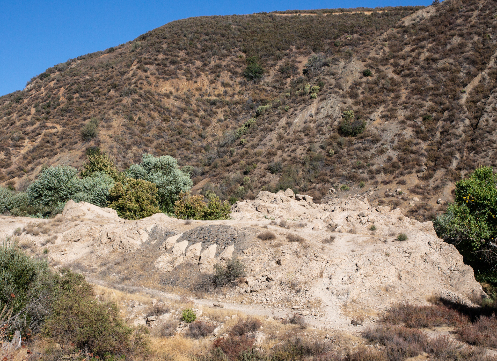
We finally made it to the dam site in the waning half of the afternoon and spent a half an hour or so hiking part of the area (it’s worth more time; I hope to come back … soon-ish).

There is a lot of great background material on what happened at the dam. The best may be from J. David Rogers, a Berkeley-trained professor of geological engineering at the Missouri University of Science and Technology in Rolla who has spent decades investigating why the dam failed and documenting the disaster’s effect on the practice of engineering.

In one of his many papers and presentations on St. Francis Dam, he summarizes the catastrophe:

“The dam failed catastrophically near midnight on March 12/13, 1928, in its second year of operation. … The resulting flood swept down San Francisquito Canyon, with an initial depth of 140 feet above the streambed. About five minutes later, the flood destroyed a powerhouse (and workers’ community) approximately 7,300 feet downstream, killing 126 of the 129 people living there. The flood wave swept on down the canyon, widening considerably at its juncture with the Santa Clara River coming out of Soledad Canyon. It then swept through Castaic Junction and on down the Santa Clara River Valley, blasting a Southern California Edison construction camp (killing 84 of the 140 workers encamped there), thence inundating the migrant farm community at Camulos, before skimming the lower elevations of the established cities of Fillmore, Santa Paula, Saticoy, and Montalvo. The flood waters reached the ocean around 5:30 a.m., after traveling approximately 52 miles. The official death toll was 432 persons, making it the greatest engineering tragedy recorded in America in the 20th century. But those official statistics did not include Mexican migrant farm workers, of which, an unknown number also perished. One hundred seventy-nine of the listed victim’s bodies were never recovered, including those of damkeeper Tony Harnesfaeger and his 6-year-old-son.”

As to what that disaster looked like, here’s one great resource, by way of the Los Angeles Times: “From the Archives: The 1928 St. Francis Dam collapse.”

The magnitude of the tragedy is a little hard to grasp standing at the dam site. There are some monumental heaps of rubble. If you look around, you can see evidence that the piles of broken concrete were part of something bigger.

But nature is reclaiming the site. A cool wind blew up through the cottonwoods and maples that have taken over the streambed where the calamity began. San Francisquito Creek sounded fresh and alive.

One note: It’s a little odd that there’s no official recognition of the site beyond a state historical marker about a mile and a half away — at the powerhouse that was destroyed in the 1928 torrent. This is a place — apparently national forest land — that deserves to be remembered and interpreted.

Road Blog: Days and Nights in L.A.

The Eli Broad wing of the Los Angeles County Museum of Art on Wilshire Avenue.

I have spent nearly all of the last 42 years in California, and all of that in the San Francisco Bay Area. I’ve visited Los Angeles about a dozen times. I only get to double figures by counting episodes like the time I delivered a drive-away car, a white Chevy Vega station wagon, to its perhaps rueful owner in Venice Beach; and day trips to do interviews for stories I’ve worked on; and visits to Disneyland, which some may dispute involve a visit to “Los Angeles.” It is not an impressive list, especially considering you can’t have any real idea of California without at least a passing acquaintance with this place.

So here we are on Day Three of dropping in for a visit and just … staying put for the most part.

Example of what I mean by “staying put.” Thom and Megan found an apartment that’s a short walk from the Los Angeles County Museum of Art. Today, we went to check the place out and spent the afternoon there (and spent virtually all of the time visiting one exhibit on the evolution and applications, practical and artistic, of three-dimensional imaging technology.

After that, it was back to the apartment, then a hike to the Los Angeles Farmer’s Market — which is actually a warren of dozens of restaurants and shops, including a couple that sell produce, that is reminiscent of the shopping district adjacent to Tokyo’s Asakusa Shrine — to buy some salad stuff for dinner, which was pizza.

Anyway: This is Night Three in Los Angeles — and I believe it’s the first time I’ve ever spent three nights here in a row.

Tomorrow: Breakfast here, then heading out. Only one stop set on the itinerary: the site of St. Francis Dam, northeast of the city, which collapsed 90 years ago this year and killed about 450 people. Considered by many to be the biggest civil engineering disaster in U.S. history. (William Mulholland, the general manager and chief engineer of L.A. Water and Power, had pronounced the new dam sound 12 hours before it failed.)

Road Blog: The PIts

The skeleton of Bison antiquus (Ancient bison) at the La Brea Tar Pits museum.

The tourists in Los Angeles today:

1) Did not fall down on the sidewalk.

2) Went to the La Brea Tar Pits (more below).

3) Watched a painful (for us) college football game.

4) Drove up to the Griffith Park Observatory, along with a huge crowd on hand to mark the equinox. We saw lots of people, lots of lights in the city below, and no parking spaces. We shall return.

About the pits: Growing up, the La Brea Tar Pits seemed to be part of an obscure joke. Visiting today and seeing them in person — the real science growing out of the millions of fossils recovered there and how the place fits into the ancient and modern city — I wondered why I thought so.

In the 1950s, there was a Bugs Bunny cartoon, “My Bunny Lies Over the Sea,” that makes an incidental mention of La Brea. It’s something slight and before my time, so I thought I must have picked up on the joke someplace else.

Johnny Carson came to mind. I don’t doubt that he was just one of many who found something odd and out of place about the asphalt deposits right in the middle of Los Angeles and made them part of a punchline. Having watched Carson many, many times — and given his long tenure here in L.A. — it seems likely that that’s where I picked up on the tar pit jokes.

Thanks to the Sometimes Magic Memory Machine, here’s an extended Carson riff — one bad joke after another — on the La Brea Tar Pits.

Road Blog: City of Sprawled-Out Visitors

5th Street in Los Angeles, not too far from the La Brea tar pits in one direction and Beverly Hills in the other.

We drove down to Los Angeles from Berkeley today. History was made: Kate drove the first two-thirds of the trip, her first time negotiating the Interstate 5-San Joaquin Valley raceway. (As it happens, we haven’t taken I-5 south through the valley much, even in our 30-some years driving around California together, and when we have, I’ve been at the wheel.)

We’re here to visit Thom and Megan (that’s our son and his girlfriend, if people still say girlfriend), who just moved down here. After we got to our hotel, a little after dark, Kate and I walked over to their place, which is about a mile away. We remarked, as some non-Angelenos do, that there are not a lot of pedestrians on the street, even in this well-groomed old neighborhood. We also noted that some of the sidewalks are in amazingly bad shape, pushed up by tree roots in this well-groomed old neighborhood. I managed to trip on a panel of concrete jutting up a good 3 or 4 inches higher than the preceding slab.

The fall was not graceful, and it hurt enough that I was content to lie on the curb strip for a minute before I got back up. No lasting damage beyond a couple of skinned knees. It wasn’t fun, but once I started walking again and the little bit of adrenaline or endorphins or whatever kicked in, I actually felt oddly exhilarated.

Picture above: a front walk on 5th Street, near where we are staying and not far from where I fell on my face.

Illuminating Dark Corners of the California Vehicle Code

Shattuck Avenue and Walnut Street, Berkeley.
Curious fact: Until this year, it was against the law in California to start across a street after the countdown timer started (or when the red “don’t cross” hand appeared).

That law was mostly unenforced, except in Los Angeles, where the LAPD went after people hard.

A state legislator from down there got a bill passed (and the governor’s signature on that bill) that now allows pedestrians to start across on the countdown as long as they make it to the other side — or can stop in a safe place mid-street, like a median — by the time the counter hits zero.

For intersections with the older signals — those that display the walking man or the red hand only, with no timer, it’s still illegal to begin crossing once the hand starts flashing.