
Rainy. Then just drippy.
Technorati Tags: berkeley

"You want it to be one way. But it's the other way."
Rainy. Then just drippy.
Technorati Tags: berkeley
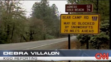
*CNN put on a half-hour report last night on the Kim story (on “Paula Zahn Now” ). A reporter and crew traveled with some locals over Bear Camp Road to BLM 34-8-36, then down to the spot where the Kims stopped (CNN published a transcript of the show and a brief Web story on the trip down to where the car was found). One thing that distinguishes the CNN report from others is that it questions the Kim’s judgment in taking the route, especially the BLM turnoff. (Image above: From a KGO (San Francisco) TV report carried by CNN on December 8; the sign displayed is near Merlin, Oregon, close to the eastern end of Bear Camp Road and Interstate 5).
*When maps don’t help: Just an aside, and I apologize if it’s an obvious one: It’s clear from all the reporting on the story that the Kims used an Oregon road map–probably the 2005 version of the state’s official map–to choose their route over the mountains. It has also been widely reported that James Kim used the map to try to decide what path to take out of the wilderness. But that map was useless for the kind of navigation he was attempting. Since it covers the entire state, Its scale is vast, so it omits many local features (such as the creek we was seeking to follow). And since it’s a road map, it contains no details of topography. You can go for a nice drive without the kind of information the map lacks; but you can hardly find your way through the back-country–even when you’re on a logging road–without that information. (Here’s the topo view of the spot, marked with a red cross and the elevation notation 2402, where the Kims stopped the night they got lost; the Rogue River, at approximate elevation 520 feet above sea level, is to the upper right).
*When the Web helps: Early on, a lot was made of the possibility that the Kims used online mapping services that might have given them directions to use Bear Camp Road as a short cut to Gold Beach. There’s nothing to those suggestions, according to accounts of what Kati Kim told police. Online maps, used by themselves on the fly, would be no more help than the paper state map the Kims did use. Some of the tools that come along with online maps–for instance, Google Maps satellite views and Google Earth’s ability to let users “fly” a route–do make it possible to get a lot more information and perspective on a route than a traditional two-dimensional map. The caveat is that you have to take time to study what the newer tools are really telling you, keeping in mind that the real world will look different from the virtual one, no matter how sophisticated the imagery (check a comparison of the Google Earth image of the Kims’ location with a photograph of the car site; and, as noted above, there’s also the topographical view to consult).
*Wingnuts Weigh In, Again: A blogging astrologer has come forth with interpretations of both James Kim’s natal and death horoscopes (this despite knowing neither the time of his birth nor the day of his death; whatever, as they say in astrology circles).
Odds and ends in the aftermath of the Kim family story. With a couple notable suggestions, the coverage has cooled off (though the Kim story seems to have made news of lost folks a hot topic in the media world right now: three climbers lost on Mount Hood (still missing); a South Carolina couple who vanished during a drive up to visit a daughter in New York (they died); and a couple of back-country dirt bikers who got confused during a weekend storm in the Sierra Nevada and had to be rescued (their ordeal included breaking into a cabin, building a fire and helping themselves to Bloody Mary fixins while they waited for the weather to improve).
The most significant new story on the Kims appeared in Sunday’s Chronicle: The paper, using some updated geographic data, reported that James Kim hiked 16 miles, not 10, during his attempt to reach help. The Kims drove about six miles further down the dead-end Bureau of Land Management road on which they became stranded than previously believed. Among other things, that means:
On Durant Avenue, a couple blocks west of Telegraph, about an hour before dark. I happened to look up and see a large-ish gray bird sitting on a telephone wire, facing the other way. Pigeon. Pigeon? Maybe too big for that. Looking a little harder, it looked like a little hawk. I crossed the street and looked up. Its chest was reddish, and it had a little slate-colored cap: either a sharp-shinned or a Cooper’s hawk. Cooper’s hawks we’ve had in our neighborhood before: One caught a morning dove in our backyard once; and another time, we were walking up to a nearby restaurant when we noticed feathers floating down from the top of a telephone pole: a Cooper’s hawk taking apart its own evening repast (mourning dove again). After nearly 30 years here, I’m still surprised by the wild things that set up housekeeping right here in the middle of the city.
Technorati Tags: berkeley
Over the last few weeks, Scout (a.k.a. The Dog) seems to have become obsessed with ground squirrels that apparently infest Chavez Park, the place we take him to run. He’ll stop near a fresh burrow and give it the once over; every once in a while, he’ll dive nose first into one and start digging furiously. So far as we can tell, he’s never come close to catching anything; most of the time I figure the squirrels are looking out from some other entrance to their burrows and having a good laugh.
But maybe not.
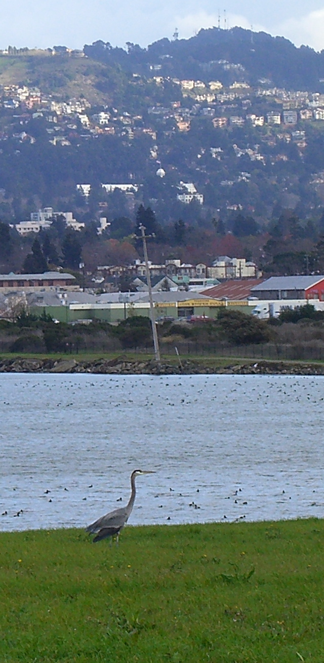
The other day, we saw a great blue heron in the meadow we cross on our way to the off-leash area. Scout was so fixated on squirrel world that even when we were within 100 feet of the bird, which stood about 30 or 36 inches tall, he was oblivious to it. We gave it a wide berth, in any case. When we came back about 40 minutes later, it was still there, though it had moved about 100 yards or so across the grass. It wasn’t until I stopped and watched that I realized it, too, was hunting whatever is in those burrows (Scout still was paying no attention, though I put him on the leash so he wouldn’t go charging after the heron once he spotted it). It struck twice while I watched, plunging its beak into the burrow holes, but it came up with nothing.
After a while, a couple stopped and watched what was going on. The guy said he’d seen herons catch squirrels in the field–impale them on their beaks, then sort of toss them up and swallow them. “A couple of times I’ve seen herons out their with their beaks completely red with blood.” I think the herons have a couple advantages over Scout and his like: they’re stealthier, they strike suddenly, and if they hit their target, there’s no fight.
Not sure if the bird above is the same one we saw the other day or not (didn’t have my camera with me then). It was in the same place, anyway (for a local reference in the picture: that big white building that appears above the telephone pole in the middle distance is the Claremont Hotel, which is probably three miles in a straight line from where we were; the high point in the hills beyond is Vollmer Peak Round Top, about 1,900 1,760 feet above sea level and about six eight miles away).
Technorati Tags: berkeley, california
Some more details of the Kim family’s ordeal from newspaper accounts the last couple of days; and also a few items on the aftermath; for instance, the locals are talking a lot more about how frequently out-of-towners get lost on the complex of roads across the mountains and are talking about putting up some new warning signs or taking other measures.
‘Hypothermia Killed Father, Autopsy Shows‘
AP/Medford Mail Tribune (12/8)
… The snow was so heavy, Kim opened and leaned out a car door trying to see, (Oregon State Pollce Lt. Gregg) Hastings said.
“They got about 15 miles off Bear Camp Road before they decided to stop,” Hastings said.
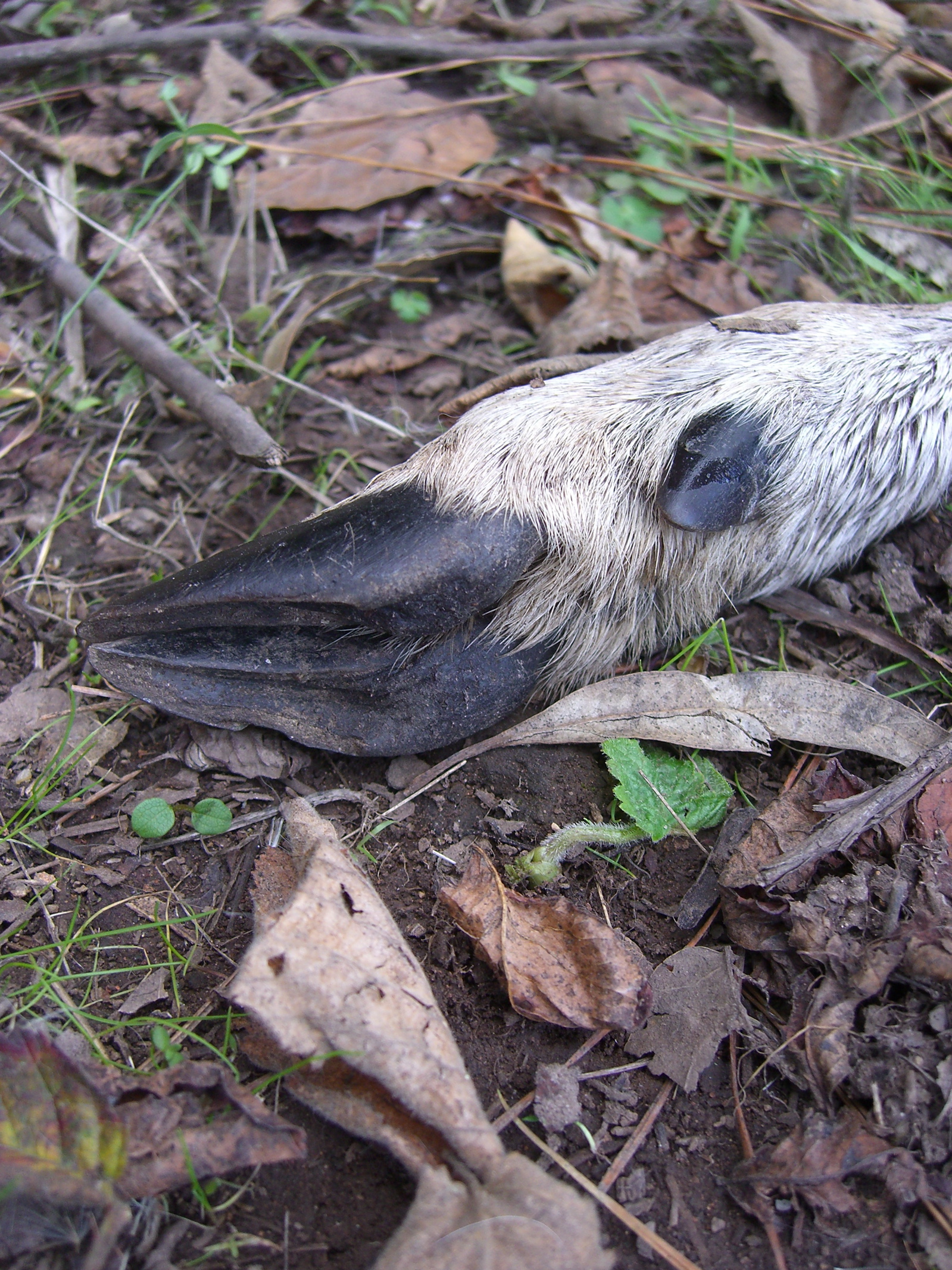
You start taking walks in the woods with a dog, and you start finding things you’d miss because you don’t, after all, have a very sharp nose. Along the Seaview Trail in the Berkeley Hills early this afternoon, Scout (a.k.a. The Dog) started nosing something lying in the weeds. When I caught up with him, I saw what he was interested in; at first glance, it looked like a little carcass tied to a couple of bloody sticks. I picked up a twig and turned it over, and saw that it was the lower part of a deer’s leg. The bloody sticks were bones that had been stripped bare by a coyote or some other hills varmint (OK–there are mountain lions up there, and they’d have an easier time dispatching a deer than a coyote would, but I didn’t think to look for any tracks; in any case, if the predator was a cat, it probably left plenty for the coyotes and other scavengers to gnaw on). Looking at it now, I’m surprised by the delicacy of it.
Technorati Tags: berkeley, california
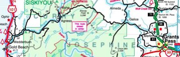
A detail from the official Oregon state road map (PDF) reportedly given to the Kims in Wilsonville, Oregon (click for larger view) the day they became lost. Bear Camp Road (also known as Galice-Agness Road and National Forest Road 23) is the road marked in black with the box noting “this route closed in winter.”
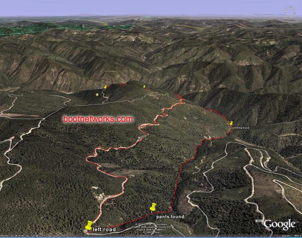
Below is one of a series of 3D images (not clear to me who produced them) that give a feel for the terrain in which Kim was lost and demonstrate more dramatically than other maps I’ve seen how far he traveleled, the degree to which he doubled back in his apparent attempt to get to the Rogue River, and how close he was to safety if he had chosen to go the other way on the road when he left the family car. Again, click for the full-size image (or try the link above for the full series of images).
[Update 12/13: See post on my brief interview with the Oregon State Police.]
Was James Kim advised to avoid the road he took into the mountains after Thanksgiving or not? Several days after the family was reported missing, a report surfaced that on Saturday, November 25–the day they were last seen–the Kims had stopped in Wilsonville, Oregon, to get travel directions. Eventually, the report became more explicit: Not only had the Kims stopped at the town’s Chamber of Commerce (which is housed in a 5,000-square-foot building with the Clackamas County Regional Visitor Information Center), but James Kim had inquired about scenic routes to their destination, Gold Beach, Oregon. A volunteer in the center pointed out Bear Camp Road on an official state road map and highlighted it; but she also reportedly warned against taking the road in winter. That much of the account was published online by CNET, James Kim’s employer. But Wednesday, the day Kim was found dead, an Oregon state police public information officer said the report was false or unreliable.
Knowing what happened won’t bring James Kim back or ease his family’s suffering. But maybe having a straightforward account of how the family wound up where it did could help others avoid the same fate (though I admit that when another account suggests the Kims kept going even after they saw several signs warning about snow on the road, you wonder if even that point is moot). If nothing else, a contradiction like this begs to be resolved.
So I called up the Wilsonville Chamber of Commerce this morning and asked for the guy I’d seen quoted in stories, Mark Ottenad, the executive director. I told him I wanted to try to clear up the confusion about his account and the state police statements. He suggested that part of the issue was that people who stop at the building, which has a sign referring to the Clackamas County visitor’s center, don’t realize that they’re actually at the Chamber of Commerce, too. But he stood by the account he’s told before about the Kims’ visit:
“I spoke to our office manager and verified that a family matching the description of the Kim family were here. They did not sign the guest book. One of our visitor information specialists talked to them, and the man asked about the scenic route to Gold Beach, and asked her to highlight it on the map. She specifically cautioned against taking that road or any forest road in the winter.”
Ottenad said the reason that the volunteer information specialist didn’t report the encounter was that the description of the family–parents and two young girls–didn’t add up for her at first. “She thought the baby was a boy,” he said. But when she saw pictures of the family on Saturday, December 2–coincidentally, the day James Kim began his hike to find help–she immediately recognized them and alerted the state police. Ottenad said the volunteer “is a grandmother herself. She’s personally devastated by what happened.”
Ottenad said that given the history of travelers getting stranded on Bear Camp Road (also known locally as Galice Road or Galice-Agness Road), “I’ll admit I’m surprised the authorities didn’t start looking up there first. That’s where I assumed they were looking.”
I’ve got a call in to Lt. Gregg Hastings, the Oregon state police spokesman who called the Chamber of Commerce visit story “false” to see what he says.
A few details on the Kim family ordeal from one of the local papers, the Medford Mail-Tribune. Some of this sheds light on how the Kims wound up where they were and might explain why James Kim left the road to bushwhack through incredibly difficult terrain :
From a story online today headlined “Tragic Ending“:
“Authorities said that over a period of days, Kati Kim recalled more and more them details that allowed them to piece together her husband’s final days. …
“… After stopping for dinner in Roseburg on Nov. 25, they headed south on Interstate 5, intending to cross the Coast Range on Oregon Highway 42.
“Kati Kim told searchers that when they realized they had missed the turnoff, they looked at a roadmap and found a direct route that went from the little town of Merlin over the mountains to Gold Beach. They did not consult their two laptop computers for an online map.
“After leaving the freeway, the Kims drove past a gas station, pizza parlor and coffee shop. On the way they passed at least three yellow signs warning that Bear Camp Road to Agnes and Gold Beach might be blocked by snowdrifts. The road is paved but one lane, originally built to haul logs out of the Siskiyou National Forest.
“Driving higher through the snow in their all-wheel-drive silver Saab station wagon, the Kims came to a fork. A fourth yellow sign warned of snowdrifts blocking the way if they took the left fork to Gold Beach. They took the right fork, not knowing where it went.
“Kati Kim told searchers they got stuck in snow once, managed to get turned around, then decided to stay put because they were low on gas. With almost no food or water, the family waited a week, running the car to keep warm at night, then burning the tires. When the small supply of baby food ran out, Kati Kim nursed her daughters.
“James Kim left the car, and then the road, and bushwhacked five miles down the steep canyon, covering about seven miles through rough country, but ending up about a mile as the crow flies from the car.
” ‘It seems superhuman to me to cover that amount of distance given what he had,’ said [Josephine County Undersheriff Brian] Anderson.
From “Searcher: Father’s final effort ‘heroic’ “:
The story quotes Randy Jones, a local helicopter pilot who leads aerial seach-and-rescue efforts for local agencies and helped track James Kim:
“Jones said Kim apparently walked along the road for four or five miles. Then, his tracks crossed paths with a big black bear headed downhill across the road. Jones speculated that Kim headed down the steep ravine to avoid the animal, which appears to have followed him.
Kim hiked several more miles in the Big Windy Creek drainage.
“Those were the toughest miles anyone could traverse,” Jones said. “I doubt any human has ever walked in there before him.”
He described the rugged territory as “virgin wilderness,” with old-growth trees towering more than 200 feet high, heavy brush, fallen logs and boulders, as well as cliffs walling the creek in some areas.
Searchers working their way down the drainage Tuesday discovered a spare pair of pants that Kim had left in what they hoped was a sign for them. From the air, teams spotted a collection of clothing and Jones helped coordinate lowering a Jackson County SWAT team deputy 200 feet down a rope to collect them.
“Those were not there Monday,” Jones said. “He was still on the move Tuesday.”
And last, this short snippet from today’s San Francisco Chronicle:
“In the end, Kim’s circuitous hike took him to within a mile as the crow flies from the spot where he had left his stranded family in their car. Rescuers said that if he had continued down the road in the direction he was driving when the car became stuck on Nov. 25, he would have reached a lodge and almost certain safety.”