Lake Abert, 1990

Lake Abert, Oregon. October 1990.

Lake Abert, above, is along U.S. 395 in southern Oregon, about 80 miles east of Klamath Falls and 75 miles north of Alturas, California. I passed by during a trip with my dad in October 1990. I remember it was a Friday evening, and we’d had a full day of traveling south from Lewiston, Idaho, with one significant misadventure along the way. We’d locked the keys in our rental car when we were about 50 miles from the nearest town. It was cold and starting to snow a little. My solution, which I’m not too sure I’d improve upon now, was to break one of the rear windows to get back in. One discovery that led to was that our Ford Taurus got about half the normal gas mileage when you drove at highway speeds with a broken-out window. The effects of increased drag, I guess. We stopped at a town along the way — John Day, maybe — and got a piece of cardboard that we taped in the window opening. That was enough of a closure that the mileage went back almost to normal for the rest of the trip.

We stopped at Lake Abert, which for a long time I believed was Lake Albert, around sunset. We had a ways to go, since the next motel was in Alturas. The light was beautiful, of course, and the way I remember the scene, it was completely still and silent. I took eight shots for a panorama with whatever little film camera I was carrying. The developed prints have been shuffled from one drawer to the next for 30 years. But in a fit of archival exploration, I grabbed them, scanned them (30 years of dust and grunge included) and panaroma-ized them in an application called Hugin (neither Lightroom nor Photoshop recognized all eight shots as part of the same scene for whatever reason).

I didn’t realize until just now, as I looked for information on the lake, that the moment we captured was in a sense a fortuitous one. In the early ’90s, Lake Abert went into a decline attributed to agricultural water diversions and climate change. Water levels have dropped; salinity levels — Lake Abert is Oregon’s only “hypersaline” saltwater lake — have risen. That’s a combination that caused a sharp drop in brine shrimp and other organisms in the lake’s waters; that in turn triggered a decline in the number of water birds visiting and nesting at the lake.

The decline has led to proposals for new environmental protections, including declaring Lake Abert “a wild and scenic river.” A quick search turned up a couple of other decent background pieces on the lake from recent years: Salinity and Water Levels Changing the Face of Lake Abert Wildlife (2018) and Oregon’s Only Saltwater Lake Is Disappearing, and Scientists Don’t Know Why (2014).

Portrait of the Drought: Lake Don Pedro

lakedonpedro-a.jpg

In our last installment, we were taking in the sights of Lake McClure just as night fell. Now, let’s reverse gears and go about an hour or so backwards, when I arrived at Lake Don Pedro — on the Tuolumne River east of Modesto — after an afternoon of noodling around near downtown Modesto (photo subjects: church, train station turned bus depot), Roberts Ferry Cemetery (graves) and numerous pretty spots along Highway 132, aka The Unknown (to Me) Highway, to look at trees, hills, rocks and clouds.

Highway 132, which heads east from Interstate 580 south of Tracy and goes through Modesto (city) and Empire, Waterford and LaGrange (town, town, hamlet), is the perfect route if you want to see two of California’s biggest reservoirs because a) the lakes almost touch each other and b) the road runs right between them. Here’s the map:

So I thought that I’d drive up there and see both drought-reduced lakes and, if I managed my time wisely, have time to get to a third a little further north, New Melones Reservoir, on the Stanislaus River. That was too big an if. I took it easy Sunday morning, found a few chores to do, sat and thought about it a little while, considered what a beautiful day it was, checked the time of sunset, saw that it was almost exactly 6 p.m., then finally, about 1:30.

I will say this: The light was beautiful all the way out of the Bay Area, across the Central Valley and into the foothills. As I drove out there, I wondered whether I would have enough time to happen across anything that would say anything unique about each lake. After awhile, the once-drowned, now-denuded reservoir landscape takes on a certain sameness: the red earth, the bare slopes showing the lines of the receding lake, the out-of-commission boat ramps, the house boats confined shrinking bays.

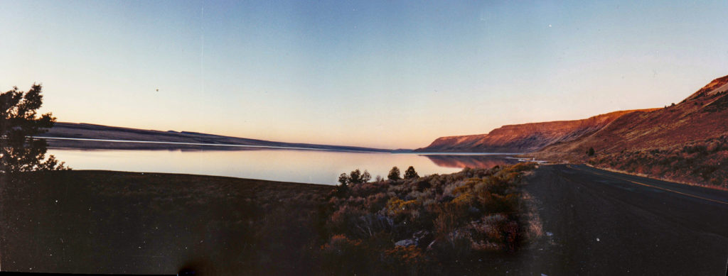
When I finally got to Lake Don Pedro — according to a credible-sounding history, it’s named after a Frenchman, Pierre Sainsevain, who came to California in the 1830s, became naturalized as a Mexican citizen, and was granted land near Santa Cruz as Don Pedro before heading to the Sierra foothills during the Gold Rush — it was 5:30 and the shadows were getting pretty long. I shot a few pictures (a couple of them are posted here). It felt haphazard. I wasn’t able to frame anything really different from what I’d seen at, say, Lake Oroville.

Then I headed to Lake McClure, But we’ve already been there, blogwise. It happened to be a more dramatic spot, the lake is much lower than Don Pedro, and the just-after-sunset light there added a dramatic element.

One other thing to note here about the appearance of the lakes in these two posts:

Lake Don Pedro is a big reservoir, with a capacity just over 2 million acre-feet. It’s 43 percent of capacity right now, and its surface elevation is 710 feet above sea level. That’s 120 feet below its “full” elevation, 830 feet. Lake McClure is about half the capacity of Don Pedro, and is currently at just 9 percent capacity. Its surface elevation is currently 605 feet — 274 feet below it’s brim-full level.

lakedonpedro-b.jpg

Audio Experiment: Talking Groundwater

OK, here’s another little experiment. I spent part of the last 10 days or so taking a little bit of a crash course in California groundwater for a radio feature. The feature’s done, but I still need to do a web post for program I did the story for (“America Abroad,” distributed by Public Radio International). I’ve had a hard time sitting down and writing again after crashing for the radio deadline, so I decided to just record some of the stuff I’ve packed into my brain on this topic. The result is what might pass for a podcast, though I’m not betting that the world is waiting for 30 minutes of talk on a resource that’s mostly invisible.

Slideshow: Lake Oroville, Before and After

Thanks to the miracles of software and the Internet, I put together a short slideshow comparing scenes at Lake Oroville as I shot them late last March and yesterday. If I’d known back then to what extent the lake would empty out, I would have taken pictures all along the shoreline. As it was, the pictures I did take of the lake were an afterthought, something to do before we started to head home.

The big surprise in the “after” pictures, the ones I took yesterday, is the landscape revealed by the receding waters. There’s no hint looking at the surface in March what the underwater topography looks like. And it’s amazing looking at the exposed landscape now (it was drowned in 1969, when the new reservoir was first filled) and how completely it’s been scoured of anything that might suggest that before Oroville Dam was built, these were canyons choked with oak, pine and brush.

Here’s the slideshow which includes a few bonus shots at the end):

Friday Lawn Report

sprinkler051812-2.jpg

It seems like just a couple weeks ago things were still a little damp from the last of our spring rains. I mowed the lawn one Sunday, then went away on a short trip. I came back to find the dry season had taken over. Our little patch of lawn in the backyard, so recently lush, was already starting to go brown. So after mowing last weekend, I broke out a sprinkler (for the back only; our scruffy front lawn is pretty much a weed patch fringed with some plantings; so much for curb appeal, but then that’s the price for my guilty relationship with outdoor water use).

After I turned the sprinkler on, I went back in the house to start coffee preparations. Looking out the kitchen window, I saw a hummingbird hovering just above the spray over the lawn. Getting a sip of water, I guess.

California Water Geek-Out, Maps Edition

A couple years ago, I made up what I don’t mind saying is a pretty cool Google Maps map outlining where the proceeds of a planned $11 billion California water bond would go (here’s the link). Not to shortchange the amazing capacity of Google Maps, but once you’d played with them for awhile you want to do more. And if you’re adept with code, you can muck around and do something more sophisticated with Google Maps. I am not allergic or adverse to code, but neither am I adept and it would probably take me a while to learn even the basics. But I am impatient and want to find a shortcut.

So, searching around for online mapping tools today, I happened across the National Atlas. There is no such thing as a map that’s not cool (or at least interesting in some way), but the site and basic outline map on the Map Maker page are a little plain vanilla. But then I started to play with it a little: I drilled in on California, then selected some data layers–highways, lakes and rivers, average precipitation. OK–the result was both useful, if I had a use for it, and kind of pretty (precipitation data will do that every time). Then I saw a layer for dams, and added that. Instantaneously, I had a view of the region that both answered and provoked my curiosity (there are at least 1,200 dams under state jurisdiction here–meaning they’re at least 25 feet or store at least 50 acre feet of water). That is a lot of dams, and when you click on individual structures on the map, you realize how few of them you know anything about. I can’t find a way to embed the map here, but here’s the link. Below is a screen shot (click for larger version); every inverted triangle is a dam.

atlas.png

Another layer you could add to the map: A grid that depicts an index of aerial maps. I superimposed the grid to take a look at an aerial photograph of the area of Lake Berryessa, the large elongated body of water at lower center, just west of Interstate 505. The lake (the state’s seventh largest reservoir, with a capacity of 1.6 million acre feet) is formed by Monticello Dam, which impounds a stream called Putah Creek about seven miles as the crow flies west of the town of Winters. I know the dam and the road that passes it from many bike rides from Davis, and one outstanding feature of the little visitors area at the top of the dam is the Glory Hole. It’s a circular intake for the reservoir’s spillway, which empties into Putah Creek.

So, once I found the aerial image (you need to superimpose the aerial photograph grid from the map layers, click on the “Identify” tab above the map, then click again on the spot you want to take a look at; the link to the image is in the “Identify” pop-up window; and as I write this I see how complicated it might seem to the ordinary user), I drilled down to Monticello Dam. Here’s the image (click for a larger version):

berryessa.jpg

See that round thing to the left of the lower edge of the dam? That’s the Glory Hole. What’s remarkable here is that it’s high and dry. It does not overflow every year, but here it looks like it’s unusually exposed. It turns out the picture is dated June 16, 1993, and though the reservoir level had bounced back from the effects of a string of dry years that had shrunk it to just a third of capacity in 1991 and 1992, on this date the lake was little more than half full.

For a contrast, here’s a New Age-y slideshow on the Glory Hole in wet and dry times:

California Water: Salmon Summit Menu

salmon menu.PNG

Someone at the Environmental Defense Fund sent this to me at KQED after chatting me up about the Salmon Summit in San Francisco tomorrow (what’s the Salmon Summit? See below). I don’t know whether it’s on the level–is all that fish really going to be served? If so–cool! But obviously the real point is about water and fisheries in California.  

And as far as the summit goes: It’s a meeting organized by fishing and environmental groups to highlight the impact of both the drought and California’s water policy on salmon and other fish, and to counter the message from agriculture and water interests that 1) California is in the midst of a “regulatory” drought and 2) that California agriculture is being sacrificed to the interests of a minnow (the delta smelt).

The fishing/environmental folks (some style themselves “the salmon community”) really began this campaign last month. That’s when one of our senators, Dianne Feinstein, began pushing for a bill to guarantee water deliveries to the drought-stricken western side of the San Joaquin Valley. Her legislation would have set aside restrictions on water shipments from Northern to Southern California imposed to protect salmon and smelt.

The salmon community and allies pointed out that salmon fishing has been shut down for two years in a row because of a crash in chinook populations. They produced an economic analysis (from a Florida outfit called Southwick Associates) that calculated the cost of the salmon fishing shutdown: 23,000 jobs and perhaps billions of dollars in “lost economic opportunity” (I haven’t seen the analysis myself). Eleven members of Congress wrote Feinstein that her effort was ignoring the impact of our water problems on the salmon community and asked her to back off. (Ultimately, the Department of the Interior, parent of the Bureau of Reclamation, which delivers water to the west side through the facilities of the Central Valley Project, stepped in and is trying to broker increased water deliveries.)

So far, then, the summit sounds like a recap of what we’ve heard already. The question is what new actions the salmon community might want their legislators to take to help bring their fish back. I’m hoping to hear an answer to that tomorrow.

California Water: Facts Just Roll Right Off

Even when we don't have all the water we want in California, we never suffer a shortage of detailed, interesting information about our water. If you need an example, go and check the California Data Exchange Center, an encyclopedia of constantly updated water statistics maintained by the state Department of Water Resources. If your thirst for water numbers isn't slaked there, go next to the Central Valley Project's operations page, produced by the U.S. Bureau of Reclamation. Even bathed in all that data, though, you're just getting started. If you want to go into advanced studies, you can pore over the California Water Plan, the bible for state water issues.

You get the picture. We're not hurting for water facts. And you'd think with all that data floating around, at least some would sink in when people talk about water. But when we fight over water, we, or our brains, seem to become impermeable. You can shower them with all the facts and fancy reasoning you want, but it all beads up and runs right off.

What am I talking about? Check the flyer below, distributed in advance of this weekend's California Republican convention. It banners the inflammatory and fact-free claim that the state is in the middle of a government-created drought. But the beautiful part comes at the bottom of the announcement (original punctuation preserved):

Ecological primitivists seek to return California to the 18th century Great Desert and the federal government is an accomplice.

Cutting off water supply to people while wasting that water to the ocean for the sake of declining fish species, is decimating Central Valley agriculture, causing the loss of thousands of jobs, imposing hardship on hundreds of thousands of residents- including many Latinos, and will contribute to worldwide food shortages.

As pure fantasy, it's actually a fun piece of writing. "Ecological primitivists"? I can see the bumper sticker. It's kind of amazing to see all those words bumping around there together and not produce anything that resembles the situation in the real world.

The event has been put together by a right-wing talk radio person, Martha Montelongo, I've never heard of. It ought to be a fun meeting. 

Watercrisis

California Water: ‘The Way of Seizure and Exploitation’

A snippet from “American Places,” a 1981 book of essays by Wallace Stegner, novelist and chronicler of the West, and his like-styled son, Page. This is from a chapter Page Stegner wrote called “Here It Is: Take It.” It describes how Los Angeles siphoned off a rich, remote supply of water from the Owens Valley and details the valley’s ongoing disputes with the city. (The chapter title is taken from the words spoken in 1913 by William Mulholland, the principal architect of the Los Angeles water system, when he opened the valve that brought the first Owens Valley water to the L.A.) I can’t help but think of the current court and legislative disputes over California water when I read this. s

“…The American Way of seizure and exploitation has a long history but a dubious future. It has produced ghost towns before this when the resource ran out and the frenzy cooled and the fortune-hunters drifted away. Without suggesting that Los Angeles will become a ghost town, one knows that in the arid West there are many communities whose growth is strictly limited by the available water. To promote the growth of any community beyond its legitimate and predictable water resources is to risk one of two things: eventual slowdown or collapse and retrenchment to more realistic levels, or a continuing and often piratical engrossment of the water of other communities, at the expense of their prosperity and perhaps life.

Man, the great creator and destroyer of environments, is also part of what he creates or destroys, and rises and falls with it. In the West, water is life. From the very beginning, when people killed each other with shovels over the flow of a primitive ditch, down to the present, when cities kill each other for precisely the same reasons and with the same self-justification, water is the basis for western growth, western industry, western communities, Eventually, some larger authority, state or federal will have to play Solomon in these disputes. …”

We’ve got a Solomon of sorts–at least one of them–working on the problem now: U.S. District Court Judge Oliver Wanger of Fresno. But more on that later.

California Water: ‘The Master Condition’

“The master condition not only of any future developments in the West but of the maintenance and safeguarding of what exists there now, is the development and conservation of water production. Water, which is rigidly limited by the geography and climate, is incomparably more important than all other natural resources in the West put together.”

–Bernard de Voto, quoted in “American Places,” by Wallace Stegner

As elegant a statement as you can find to explain what all the ruckus is about.