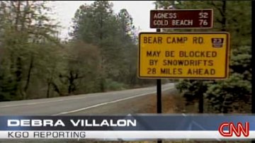
*CNN put on a half-hour report last night on the Kim story (on “Paula Zahn Now” ). A reporter and crew traveled with some locals over Bear Camp Road to BLM 34-8-36, then down to the spot where the Kims stopped (CNN published a transcript of the show and a brief Web story on the trip down to where the car was found). One thing that distinguishes the CNN report from others is that it questions the Kim’s judgment in taking the route, especially the BLM turnoff. (Image above: From a KGO (San Francisco) TV report carried by CNN on December 8; the sign displayed is near Merlin, Oregon, close to the eastern end of Bear Camp Road and Interstate 5).
*When maps don’t help: Just an aside, and I apologize if it’s an obvious one: It’s clear from all the reporting on the story that the Kims used an Oregon road map–probably the 2005 version of the state’s official map–to choose their route over the mountains. It has also been widely reported that James Kim used the map to try to decide what path to take out of the wilderness. But that map was useless for the kind of navigation he was attempting. Since it covers the entire state, Its scale is vast, so it omits many local features (such as the creek we was seeking to follow). And since it’s a road map, it contains no details of topography. You can go for a nice drive without the kind of information the map lacks; but you can hardly find your way through the back-country–even when you’re on a logging road–without that information. (Here’s the topo view of the spot, marked with a red cross and the elevation notation 2402, where the Kims stopped the night they got lost; the Rogue River, at approximate elevation 520 feet above sea level, is to the upper right).
*When the Web helps: Early on, a lot was made of the possibility that the Kims used online mapping services that might have given them directions to use Bear Camp Road as a short cut to Gold Beach. There’s nothing to those suggestions, according to accounts of what Kati Kim told police. Online maps, used by themselves on the fly, would be no more help than the paper state map the Kims did use. Some of the tools that come along with online maps–for instance, Google Maps satellite views and Google Earth’s ability to let users “fly” a route–do make it possible to get a lot more information and perspective on a route than a traditional two-dimensional map. The caveat is that you have to take time to study what the newer tools are really telling you, keeping in mind that the real world will look different from the virtual one, no matter how sophisticated the imagery (check a comparison of the Google Earth image of the Kims’ location with a photograph of the car site; and, as noted above, there’s also the topographical view to consult).
*Wingnuts Weigh In, Again: A blogging astrologer has come forth with interpretations of both James Kim’s natal and death horoscopes (this despite knowing neither the time of his birth nor the day of his death; whatever, as they say in astrology circles).

