Special Airline Edition: Reply Stop to Cancel

Jet fuel leaks from the starboard wing of Alaska Airlines Flight 1213 at O’Hare International Airport, Sept. 23, 2019.

We were in Chicago for a wedding last week and flew back to San Francisco on Monday. We got to the airport in plenty of time and discovered our flight was a little late. No worries.

We found a place to sit that had a view of the plane’s parking space and of the jetway at our gate. The incoming flight was later than advertised, finally pulling up and shutting down maybe 25 minutes late. I watched as the jetway was extended toward the plane to allow the arriving passengers to escape their confinement. But the apparatus stopped about 10 feet short of its target. The ground crew tried to retract it and re-extend it. They couldn’t get it to close the gap.

As the minutes went by, I was imagining the slow burn the passengers stuck on the plane were doing. I was wondering whether someone would appear with a couple of planks for people to walk across from jet to jetway.

What actually happened , after 20 minutes or so, was that two guys from American Airlines showed up. One of them got a step ladder and set it up adjacent to what looked like an electrical box on the jetway. Then he climbed up, took a “hundreds of Americans die every year doing stunts like this” stance, with one foot on the ladder and the other on the electrical box, and fiddled for about 10 seconds with a switch. He climbed down and signaled to someone to give the jetway a try. This time it worked. So at about 5:50, roughly 35 minutes after the plane parked, and about the exact time Flight 1213 was scheduled to pull away from the gate for the trip to San Francisco, the arriving passengers could get off.

An American Airlines technician climbs up a ladder to fiddle with a switch on a non-functioning jetway at O’Hare Gate G6.

It took about 30 minutes for everyone to make their way off the airliner and for a cleaning crew to race through the aircraft and straighten it up. Then it was our turn to get on, and I’m guessing another 20 minutes or so to hustle everyone on board. We pulled back from the gate at about 6:40, 50 minutes late, but not a disaster.

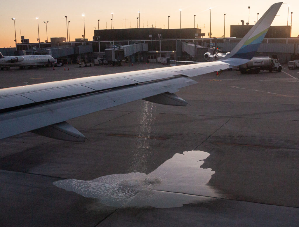
Once we were pointed toward the taxiway, but still just 50 yards or so from the gate, we had to sit for awhile to get in the takeoff queue. I was sitting pretty far back, looking out the window on the plane’s right side. Suddenly, liquid began spouting out of the wing. A lot of fluid. It kept going. What was it? Water? That didn’t make sense. Jet fuel? that wouldn’t be good. While I was pondering this mystery, which I thought someone ought to point out to the crew, someone else a few rows ahead of me said, “Hey! Look at this! Something’s coming out of the wing!”

That got a flight attendant’s attention. She looked out a window. Another crew member said, “Call them and tell them.” One of the flight attendants reassured us that there was nothing to worry about.

The liquid kept cascading to the ground. The flow gradually slowed, then stopped. Hard to say how much spilled onto the tarmac. One hundred gallons? Five hundred? Eventually, the flight’s captain got on the PA and confirmed that we had been seeing jet fuel spilling. More than once, he suggested that it had been a normal occurrence and tried to explain what happened. I’m not sure I understood, but it sounded like an issue with having failed to properly balance the fuel load between the aircraft’s tanks and that a valve had opened — to relieve fuel line pressure? — and released fuel onto the ground. (As I say, I’m not sure I understood the details. I’d love to have an Airbus mechanic explain it again.)

In any case, we had to go back to the gate so maintenance technicians could check out the issue. Then the plane took on additional fuel. Then paperwork had to be done. The plane was opened up so people could wander around the terminal if they liked — but not too far! — and maybe grab a snack. The woman setting next to Kate and me came back with pizza slices.

All of that consumed another two hours. Kate and I did not leave the plane, though we got up a couple times to stretch. Finally, all the checking and rechecking was done, the wandering passengers were called back, and at 8:40 — now nearly three hours after our scheduled departure, we again pulled back from the gate.

All that stood between us and actual flight now was the long line of airliners waiting to take off ahead of us. The wait for our turn turned out to be another 40 minutes, making our departure nearly three hours and 20 minutes late. I was hoping Alaska would spring for free beer, or at least beer nuts, as compensation for the delay. No such luck.

Long story short: We made good time to SFO, and were off our plane by 11:35 p.m. (1:35 a.m. Chicago time). I had visions of making the last cheapskate BART train back to the East Bay. But by the time we had collected our bags and made it up to the AirTrain for the ride to the BART stop, it was too late. We wound up taking a Lyft ride instead — kind of a treat, actually, and we didn’t have to schlep our bags the last couple blocks home from the station.

I was thinking about complaining to Alaska as all this was unfolding. But then I got a personal message from the airline that came in just as our plane landed. It made me feel kind of … well, see for yourself.

Cross-Country

longbeach090310.jpg (Above: Looking south down the Los Angeles River, center, and across the junction of Interstate 405, the San Diego Freeway (running right and left) and Interstate 710, the Long Beach Freeway (which runs down the river’s western bank). Long Beach Harbor is in the distance. Taken just after takeoff from Long Beach Airport, September 3, 2010. Google map link.)

I took a long bike ride once from near Boulder, at the foot of the Colorado Rockies, to east central Kansas, then turned around and came most of the way back. The route was given not in a map but in a sort of schematic of the roads on the route. That was a simple matter because a good 80 percent of the route seemed to be on a single highway, U.S. 36. There was a point marked on the diagram about 80 miles or so southeast of Boulder–the point where the Rockies vanished as you headed east across the Plains and reappeared on the westbound route.

That mark on the map made an impression: I loved the idea of a point on the landscape where such a dramatic change is made visible. Most long-distance travel, especially between the Rockies and the Appalachians, I think, is a tale of subtle changes, watching landscapes shift slowly as you gain or lose elevation or encounter wetter or dryer climatic zones. It’s much different from traveling north or south, east or west across California, where the next amazing transformation seems always to be around the next bend.

And then there’s flying across country–by which I mean commercial airline flight–which compresses experience and landforms into an extended narrative of geographic changes. I’ve often fantasized about coming up with some manual or device that would serve as a guide to what the airline passenger sees as he or she soars overhead. At first I envisioned it as a fold-out book in which each page would show landmarks, landforms and highways all the way along the air route, and now I imagine that GPS and map software can hand you a continuous unfolding picture with as much detail as you desire.

The strip of landscape that rolls out beneath the main air routes between the Bay Area and Chicago has become familiar, but it’s still exciting to see from the air: the cityscape, the bay, the bridges, the islands, the towns, the freeways, the hills and mountains that slide beneath you as you head out into the Central Valley. The Sacramento-San Joaquin Delta with its knot of waterways, the farm geometry of the valley floor, the big valley cities. Then the foothills and big reservoirs and forests as the hills turn into mountains and the checkerboard of raw-looking clearcuts. Then granite and almost before you know it you’ve vaulted the crest of the Sierra Nevada, maybe within view of Yosemite or Lake Tahoe–so much of what you see depends on what side of the fuselage you gaze from.

Then Nevada: basin and range and uncountable debris fans at the foot of mountains and dried-up courses of old floods. You might be able to place yourself by the appearance of a road–Interstate 80, maybe, or the thin ribbon of U.S. 50, or one of the north-south routes. Then maybe you get a look across one of the mountain ranges at the Great Salt Desert, signaling Utah. Maybe you see that lake, or the Wasatch Mountains rearing up from the middle of the city. The Rockies may appear, or coral-painted canyonlands, or the course of the Green River or the Colorado.

By this time you might be an hour and a half into the flight, maybe more. If you’re connecting at Denver, you might sweep down to the plains across Rocky Mountain National Park. If you’re on a non-stop, you might or might not ever see a square inch of Colorado, but you’ll see some part of the mountain chain. When that’s over, you’ll see the dry, sparsely roaded High Plains. You might meet up with Interstate 80 again near the course of the North Platte River, a rough guide to the old pioneer routes. In western Nebraska the country looks hilly and potholed. Anywhere in these dry plains you might see broad circles of wheat or alfalfa irrigated straight out of the Ogalalla Aquifer. Slowly, the roads increase and the green becomes more intense. You might see Omaha; even if you don’t, you’ll see the Missouri River below, running across a floodplain marked by tall bluffs.

After that, you’re almost home. Iowa, farmed and fertile looking and looking anything but flat, a rolling landscape broken by hundreds of small and big streams. The Mississippi is ahead, impossibly wide and complex looking as it braids among heavily wooded islands. And then it’s southwest Wisconsin or northwest Illinois, with county roads knocked askew from the preferred township grid as they straggle across thousands of square miles of glacial debris dumped in the last ice age. And then towns: Madison in the distance, Janesville, Beloit, Rockford. The Rock River. The Fox River, the suburbs, the city, the airport. Touchdown.

(Flying out here Friday, my routine was interrupted. I flew down to Long Beach, then from there to Chicago. Terra incognita, mostly, especially sitting over the plane’s port wing. But I did get glimpses. I puzzled over our route after leaving Long Beach; we took off to the northwest, then turned and flew south out over the ocean before turning to head east, and I just don’t know the landscape down there. The first good reference point I spotted was crossing the Colorado River. And after that, just a lot of guesswork. (The actual flight path appears to be here.)

When It Was Fun to Fly

Salon’s weekly “Ask the Pilot” column recalls the days when lots of people actually looked forward to getting on an airliner (me–I still like flying, even though the whole experience around it has become creepy and unpleasant):

“… [T]ry to imagine the following: You wake up early for the 45-minute subway ride to Logan International Airport in Boston. The shuttle bus brings you to Terminal C, where you stand in line to be frisked and X-rayed before reaching an overcrowded departure lounge. Half an hour later your flight pushes back, languishes in a taxiway queue for several minutes, then finally takes off. So far this is nothing exceptional, but here’s the twist: The plane’s scheduled destination is, well, Boston. The jet never climbs to more than 10,000 feet. It makes a lazy circuit above the North Shore coastline, swings eastward toward Cape Cod, then circles west in the direction of Logan. Fifteen minutes later, the landing gear clunks into place, and just like that you’re back where you started. You disembark, with smiles and handshakes all around, head for the shuttle bus, and take the subway home again.”

Technorati Tags: ,