Last Aug. 20, in a rare example of doing well ahead of a long-contemplated event, I mused about possible destinations to view the Great Solar Eclipse of 2017. One location I pondered — where we’re headed now — is western Nebraska.
(But why western Nebraska? I hear the question even before the final schwa sound of the Cornhusker State’s strangely compelling name fades away. Answer: Decent chances for good viewing weather and good odds of avoiding eclipse country gridlock. On both counts, we’ll see).
I didn’t do a whole lot in the way of eclipse preparation last year beside write that post, order an eclipse atlas, and spend hours poring over pages of Airbnb and VRBO listings. Like most of West Coast humanity, I searched out places to stay in Oregon east of the Cascades. The now-famous municipality of Madras was already booked up (I’m not counting offers to sleep for only $150 a night in prickly pear patches or cow pastures), and other promising places that would have required a drive of some length did not pan out. (I did not consider Bend, a city of some size and reputation, because I could all too easily imagine Eclipse Morning gridlock, or rangelock or whatever you call it when you don’t have a grid, with traffic heading up the road toward the totality zone.)
Thus thoughts turned again to Nebraska. (Why? See above.) I will unfold our ultimate destination, which is currently semi-unknown, as we travel this week. I can, however, share the first leg of the journey.
Our destination was Lake Tahoe, the northwest side, where an old friend is spending a couple weeks and invited us to spend our first night on the road. So We left Berkeley early in the afternoon and drove up Interstate 80. There was sporadic heavy traffic in the usual places — in Fairfield, through Davis — but we sailed for the most part and got to our spot on the lakeshore by 6:30, in time to watch the evening light descend.
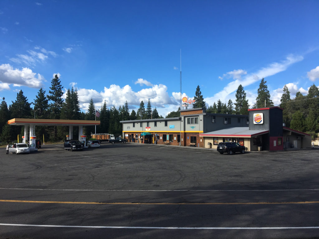
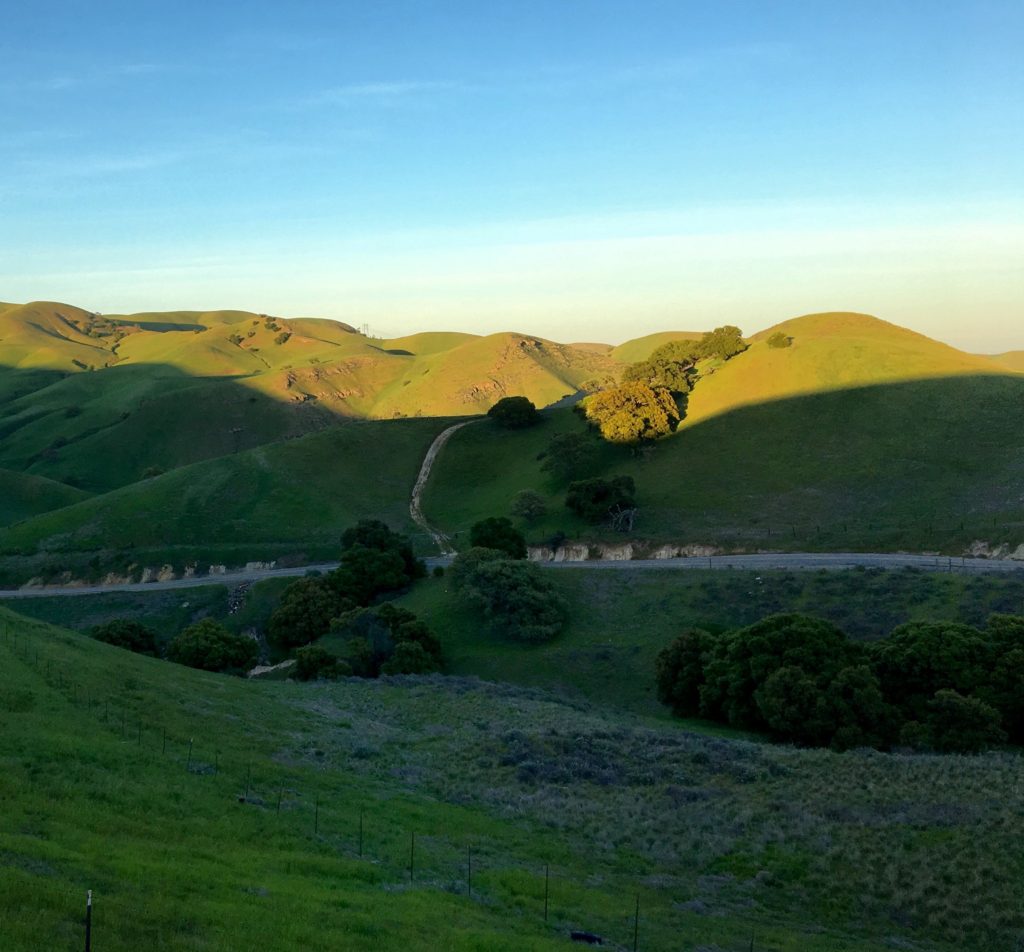
Since the this is a travelogue of sorts, there ought to be a picture. Here’s one of our first and only stop today, at Nyack, about 15 miles west of Donner Summit at an elevation of maybe 5,500 feet above sea level. It’s an unprepossessing image — Shell gas, a convenience store, a tiny Burger King, and a huge expanse of asphalt.
Back in the days when a two-lane road, U.S. 40, ran across the Sierra here, there was a resort called Nyack Lodge. In January 1952, in the middle of a very stormy winter, a westbound passenger train, the City of San Francisco, was halted by snowslides a few miles east of Nyack. Passengers were stranded for three days. When rescuers finally reached the scene, the passengers — cold, hungry, some ill from an episode of carbon monoxide poisoning — were driven to Nyack Lodge. There, they got a nice feed and were put on a rescue train that had come up from Roseville for the trip to Oakland.
Nyack, California, on Interstate 80 west of Donner Summit.
San Luis Reservoir, just west of the San Joaquin Valley town of Los Banos, is one of California’s key water facilities. Pumps in the Sacramento-San Joaquin Delta ship water down two massive canals — the state-owned California Aqueduct and the federal Delta-Mendota Canal — to a holding basin, or forebay, adjacent to the reservoir. From there, another set of pumps lifts water into the reservoir, where it’s stored before being pumped again for delivery to farm and city customers farther south. All reservoirs are artificial creations, but there’s an extra dimension of artificiality here: There’s virtually no natural inflow to the reservoir; it exists only to receive the water pouring down two huge manufactured rivers.
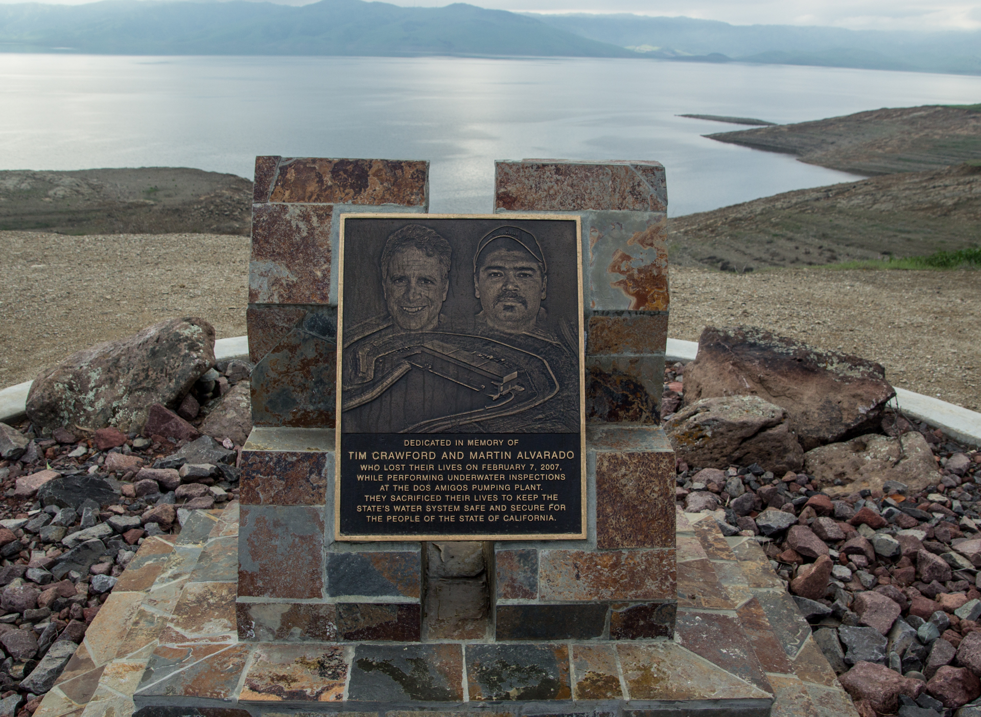
Memorial plaque at San Luis Reservoir to two Department of Water Resources divers who died in a 2007 incident at a nearby pumping plant.
The plaque above is at the Romero Visitors Center, just off Highway 152. There’s something artificial, manufactured — less than truthful — about the memorial to two divers killed at the pumping plant about 10 miles from the dam. But read the plaque first:
The plaque text:
“Dedicated in memory of Tim Crawford and Martin Alvarado, who lost their lives on Feb. 7, 2007, while performing underwater inspections at the Dos Amigos Pumping Plant. They sacrificed their lives to keep the state’s water supply safe and secure for the people of the state of California.”
The wording is curious. These two men “sacrificed their lives to keep the state’s water supply safe and secure”?
It sounds heroic. What happened?
I had no idea. But armed with the two names, it’s easy to find out.
The two divers went into the water to inspect “trash racks” just upstream of the pumps at the Dos Amigos Pumping Plant, apparently looking for invasive mussels. Five of the six pumps at the facility were shut down, and one was running full bore. Somehow the divers wound up near the operating pump. The powerful current there pulled them in and pinned them against the trash rack, a huge steel grate designed to stop large debris from going through the pump.
The untrained fellow Department of Water Resources employee who had been given the job of “tending” the dive soon lost sight of the divers’ bubbles, his only means of tracking the men, but had no idea what to do. By the time he thought to alert anyone in the pumping plant, the divers were probably out of air. It took more than an hour after trouble was detected to shut down the operating pump, and another 35 minutes after that before a recovery diver was in the water. Both divers were found at the bottom of the aqueduct, drowned. Subsequent investigations found a series of missteps, including some by the divers themselves, that contributed to the outcome.
I get the human impulse behind injecting a note of heroism into the plaque’s language. We want to find something to redeem such awful deaths, to give the sacrifice a purpose.
But it might have been more to the point, and a more fitting memorial, to say something like: “Dedicated in hopes that their deaths might serve to prevent future tragedies.” A message like that might serve as a living reminder to those responsible for preventing incidents that they must remain vigilant.
We had some heat today. We’ll call the high here in the refined northern reaches of Berkeley 91. The official Berkeley record for June 18 is 90, set in 1895. Because one must turn cartwheels to get the data from the official station, which is on the UC Berkeley campus and overseen by a Department of Geography employee who has heretofore ignored my queries about getting data from the station, I don’t know whether that 122-year-old record was broken or not. I’ll try to remember to look for the number when it becomes available in a month or so.
But other high-temperature records were broken in the Bay Area today. To wit (data by way of the National Weather Service):
The quality of Bay Area heat is different from what I remember of Chicagoland heat: It can be scorchng if you’re out in the sun, but it’s not so bad if you can find some shade (and stay there). My recollection of hot days growing up was that there was no getting away from it; the humidity just draped the heat around you. Great if you’re looking to get a good sweat on, though.
Anyway. When the heat broke early this evening, I took The Dog out for a walk. We went to his favorite pet food store — his favorite because he gets treats every time he walks in the door. The place was closed — I knew it would be, but it was a nice walk with the evening started to cool down.
On the way home, a mockingbird was putting on a show; enough so that several passers-by, including The Dog and I, stopped. That’s the little audio clip above. In addition to the bird, there’s a siren and the sound of the dog panting. Real street sound.
It’s 11 p.m., and the temperature is 71 here in Berkeley.
That late-night warmth in mid-June would not be news in Chicagoland, where I grew up (the current temperature at Midway Airport, recorded at midnight CDT, is 78) or most of the rest of the country outside of the Pacific Northwest.
But here, 71 degrees as we move toward midnight is unusual; and reminiscent, though we don’t have midwestern humidity, of growing up in Chicago’s south suburbs.
Somehow, my parents grew up without air conditioning. We didn’t have it, either, in our house on the edge of Park Forest. It seemed impossible to sleep on really warm, humid nights, though I’m probably forgetting that fans helped.
Our dad would go to bed early; our mom was a night owl and would have some late-night TV on. Johnny Carson, maybe, or “The Late Show” movie. She’d let us stay up if it was too hot to sleep. If the night was oppressive and sticky, she’d have us take a cold shower to cool off.
Thinking back, Mom didn’t get her driver’s license until after our last summer in Park Forest. The next June — 1966, when I was 12 — we moved out to a new house built on an acre lot in the middle of the woods we had lived across the street from. It was like a jungle out there in the summer — green and moist and full of mosquitoes and lots of other wildlife.
Things changed once we moved out there. We had air conditioning. One unit upstairs, one downstairs. Outside, it might be dripping. Inside, it was miraculously cool and dry — a different world. I imagine the electric bills were staggering compared to what they had been at our old place.
Then, too, Mom had her license. Every once in a while, she’d invite us out on a late-evening jaunt — to the grocery store, or just to drive.
Poring over some doleful but absorbing statistics on U.S. military casualties in our wars going back to the American Revolution, I’m led astray from whatever purpose I had for early Memorial Day morning.
First distraction: It doesn’t seem right that most statistical roundups of American service personnel killed in our wars — like the one linked to above — exclude those who died in our many inter-war military operations. Here’s a separate Pentagon accounting of soldiers, sailors and Marines killed during operations between 1980 and 1996. The list includes:
The eight service personnel who died during the failed 1980 attempt to rescue U.S. hostages from Iran.
The 265 who died during the course of our 1982-84 “peacekeeping” mission in Lebanon (most of those casualties occurred in a single terrorist attack).
Second distraction: I reflect, as many have before me, that there’s hardly been a year in my lifetime — I go back to Eisenhower’s first term — that U.S. troops haven’t been active somewhere in the world. Here’s someone who’s come up with a politically loaded list of U.S. military-related actions, at home and abroad, going back to Wounded Knee.
Third Distraction: In exploring various sets of statistics on U.S. military casualties, I came across the Department of Defense accounting of fatalities among active-duty personnel from 1980 through 2010. (Unfortunately, I can’t find more recent definitive numbers.) In those 31 years, which span “peacetime” (there was just one death attributed to hostile action or terrorist attacks in 1980-81) through the height of the Iraq War (2007), the Pentagon says 48,834 active-duty personnel died. Here’s a breakdown of how they died: Accident: 25,073 (51.3 percent of total). Illness: 8,579 (17.6 percent). Suicide: 6,911 (14.2 percent). Hostile action: 4,814 (9.9 percent) Homicide: 2,329 (4.8 percent) Terrorist attack: 420 (.9 percent) Cause undetermined or pending: 708 (1.4 percent)
The numbers look a little different if you isolate fatalities from ongoing military operations in Iraq and Afghanistan. A recent Congressional Research Service report broke down the causes of death for those two conflicts (including all phases of the Iraq War to date). Some 5,362 (78.5 percent) of the 6,830 deaths were sustained in hostile action; 1,041 (15.2 percent) were attributed to accidents or illness; 350 (5.1 percent) to suicide, and 52 (.8 percent) to homicide (about 25 deaths are listed as “undetermined”).
I find the “self-inflicted” death count most stunning, especially the fact it appears to be so much larger than fatalities suffered in combat. If you follow this issue, you know the number of veterans who take their own lives each year dwarfs the number of service members who kill themselves while on active duty. A Department of Veterans Affairs study published last year found 7,400 veterans committed suicide in 2014, the most recent year for which data was available.
Fourth Distraction: While embarking on my military casualty StatsQuest, hours and hours ago, I came across one particularly startling number in a VA document titled America’s Wars. Page 2 of said document includes a table of veterans and veterans’ dependents currently on VA benefits rolls (“currently” as of April 2017), listed by the war(s) in which veterans served.
The table shows there’s one person out there still getting monthly benefits related to service in the Civil War. Really? Is that possible?
Yes — it turns out it is. The recipient is Irene Triplett, daughter of a man who fought on both sides in the war. She reportedly gets a monthly VA check for $73.13 that goes toward paying for care in a North Carolina nursing home. The Wall Street Journal did a long feature on her and her family a few years ago. Irene Triplett had a very tough life; the piece is well worth reading.
National Geographic followed with its own story on the “fewer than 35” surviving children of Civil War veterans and details a couple of their life stories.
April 11, 1953: My parents, Steve Brekke and Mary Hogan, are married at St. Kilian’s Roman Catholic Church, at 87th and May streets on Chicago’s South Side.
There are many pictures of the day, though I don’t have immediate access to them. One I remember is my two grandmothers, Otilia Brekke and Anne Hogan, posing together.
They were both widows. My dad’s father died in April 1932 (age 55, Parkinson’s disease), my mom’s in 1941 (age 53, lung cancer). They had brought up their children (my dad was an only child, my mom one of six) largely by themselves.
What else did they have in common? They were both Chicago natives, both the first children born in the United States to immigrant families. Their fathers were both laboring men, their mothers both with large families (huge, by today’s standards) to see to.
But there were crucial points of divergence.
Mrs. Brekke was Norwegian through and through, her Sieverson clan coming from farming country south of Kristiania (now Oslo) and becoming founding members of a Lutheran parish on the near Northwest Side. Her late husband, Sjur Brekke, had been a minister in the Norwegian-American Hauge Synod. Judging from their early correspondence and what I remember of her, her entire life was bound up with the church.
Mrs. Hogan was Irish through and through, her family arriving from a little island off the west coast of County Mayo. Needless to say, they were Roman Catholics, and by the time my parents met, she was well on her way to having sent all four of her surviving sons into the priesthood.
In other words, my soon-to-be grandmothers were staring a mixed marriage in the face.
In order for the proposed union to receive the sanction of Rome, the parties involved needed to agree to a Catholic wedding and to baptize and raise their children as Catholics. I never heard her say a word to us kids about it in later years, but I’m sure this arrangement didn’t sit well with Mrs. Brekke.
So there they are, at the old Windermere Hotel on the Hyde Park lakefront, posing for their portrait together on my parents’ big day. They are smiling, but you can almost feel the chill: Grandma Brekke, who turned 69 that year, with the slightly unnatural stare that came from her glass eye, and Mrs. Hogan, three days shy of her 55th birthday, with a cordial look that’s betrayed by what my sister Ann has pointed out were her characteristically cold eyes.
But by then, the wedding was done and Mary and Steve had embarked on the saga that would lead to me and my siblings and all the attendant joy, grief, celebration and misadventure. Whether my grandmothers smiled or not, life was going to go on.
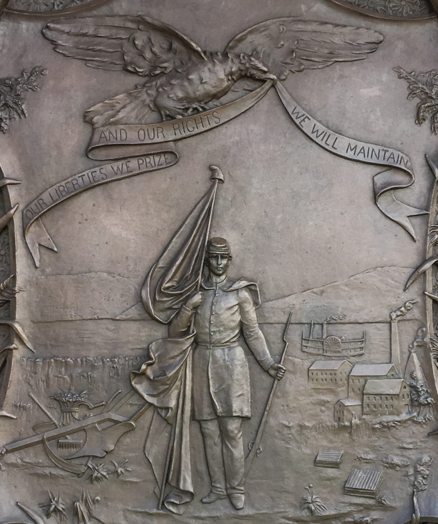
The Great Seal of Iowa, as rendered in a bas relief tablet by Alexander Doyle at the Iowa state capitol.
In 1847, the Iowa Legislature passed a law creating a state seal. More on the wording of the law, which has caused a stir in the state Capitol in recent times, in a moment.
The straightforward part of the seal is the motto: “Our liberties we prize and our rights we will maintain.” I like that: Straightforward. A little militant. No Latin.
However, the Legislature offered only a description of what the seal should look like. Here it is (and as you read it, see if there’s a phrase that kind of sticks out as a little awkward):
“The secretary of state … is … hereby authorized to procure a seal which shall be the great seal of the state of Iowa, two inches in diameter, upon which shall be engraved the following device, surrounded by the words, ‘The Great Seal of the State of Iowa’ – a sheaf and field of standing wheat, with a sickle and other farming utensils, on the left side near the bottom; a lead furnace and pile of pig lead on the right side; the citizen soldier, with a plow in his rear, supporting the American flag and liberty cap with his right hand, and his gun with his left, in the center and near the bottom; the Mississippi River in the rear of the whole, with the steamer Iowa under way; an eagle near the upper edge, holding in his beak a scroll, with the following inscription upon it: ‘Our liberties we prize, and our rights we will maintain.'”
(Yes — the Legislature wrote “with a plow in his rear.” That phrase prompted an Iowa state legislator in 2010 to offer a bill to amend the wording. Lawmakers did not act on the suggestion.)
That 1847 description left a lot to artists’ imaginations and produced a series of rather passive and homely images. Search for “Great Seal of Iowa” in Google images if you’re curious about what I mean.
I didn’t know any of that history when I visited the state capitol grounds in Des Moines last fall (2016). What struck me about the tablet or relief — OK, technically not a plaque — was what I take to be its direct reference to the Civil War. The soldier depicted is dressed as a Union infantryman. The musket he holds on his left side has bayonet fixed. The Stars and Stripes he supports with his right arm is partially draped around him. He is taking a step toward the viewer. His look is resolute and unafraid.
“Our liberties we prize and our rights we will maintain”? The bas relief makes the statement come alive. The soldier embodies the sentiment. Is there a Civil War message here — a reference, perhaps, to how seriously the state took its duty to preserve the Union?
About 75,000 Iowans — more than one in five adult men — served during the war. Some 13,000 of them died and another 8,500 were wounded and survived. Iowa’s experience largely reflected the experience of every state, North and South. In a way that’s hard to imagine today, when so few serve in our armed forces, the war touched everyone.
An entry on an Iowa state government site that describes the monuments on the capitol grounds notes that the Iowa seal tablet was commissioned in the mid-1880s and completed in the early 1890s. The war was still an enduring, dominant memory for a whole generation of Americans then, just as World War II was in the 1960s — when war stories were common prime-time TV fare and a frequent Hollywood subject.
The Iowa state site also mentions the name of the sculptor, Alexander Doyle, who had a national reputation by the time he got the commission for the tablet and a nearby drinking fountain featuring the cast bronze head of a bison.
Doyle’s reputation rested in part on his Civil War sculptures. But he was not a Yankee nationalist. His commissions came from both the North and from the defeated Confederacy — and he was especially active in New Orleans, where he created a series of statues commemorating Southern heroes.
I think if there’s a message in the Iowa Great Seal tablet, it’s that Doyle was an artist who understood the time he was depicting and the emotional expectations of his audience and knew how to translate that understanding into bronze. His was not a common talent.
Note: A version of this post also appears on Read the Plaque.
OK — so there’s a site I recently happened upon — ReadThePlaque.com — that appeals to my weakness for historical trivia and roadside finds.
There’s a bit of a back story to Read the Plaque (you can listen to it here) that involves an object lesson in observation and curiosity about the stories that are out there in the world around us. I don’t think that plaques, which by necessity offer a shorthand (if not sanitized) version of events, are the only source of those stories. But they do open a door into the past of the spaces we move through every day and, perhaps, of how our own life and experience intersects with that history.
Since I’ve made something of a habit of photographing some of the plaques I encounter — part of my visual note-taking of my daily rounds — I started submitting some of the plaques to Read the Plaque. The site invites one to “tell us about the plaque,” which I take as an invitation for added details and context to accompany the plaque text. For me, that’s an invitation to turn the submission into a mini-project. So, I’m going to take the liberty of cross-posting my Read the Plaque entries here, for posterity and my small reading public.
Here’s one I just posted for a plaque Kate and I encountered Sunday in Mojave, California:
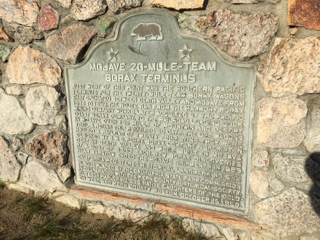
Historical marker on Highway 14 in Mojave marking long-ago terminus of borax trains from Death Valley.
This is on California Highway 14, the main drag through Mojave, a desert crossroads and would-be spaceport (Burt Rutan, the designer and builder of the X-Prize-winning SpaceShipOne and Virgin Galactic’s SpaceShipTwo, has his shop at the former Marine air base on the edge of town; the facility, now run by a county agency, is styled the Mojave Air and Space Port. It’s a boneyard for old planes, too, and is a kind of fun detour if that’s the kind of thing you’re into).
And now back to an earlier age of transportation: the 20-mule-team era.
As a child of the 1960s, “20-Mule-Team Borax” meant two things: a detergent and a TV show, “Death Valley Days,” that was hosted for a time by soon-to-be California Gov. Ronald Reagan. All I know about borax: It’s useful in many applications, from whitening clothes to metallurgy. As for its place in California history, here’s an excellent 1998 writeup from the Chicago Tribune: “More valuable than gold.”
As to the plaque: It’s on the east side of Highway 14 — that’s the right if you’re driving north through town — between Mono and Nadeau streets. It’s placed on a scrubby lot in front of a defunct and fenced-off Kentucky Fried Chicken outlet, right between a Denny’s and the Best Western Desert Winds. As usual, though I was alerted to its presence by a sign that advised I’d see a historical marker 500 feet ahead, I drove right by it the first time without seeing it.
Here’s the plaque text:
Mojave 20-Mule-Team Borax Terminus
Just west of this point was the Southern Pacific Terminus for the twenty-mule-team borax wagons that operated between Death Valley and Mojave from 1884 to 1889. The route ran from the Harmony Borax Company works, later acquired by the Pacific Coast Borax Company, to the railroad loading dock in Mojave over 165 miles of mountain and desert trail. A round trip required 20 days. The ore wagons were designed by J.W.S. Perry, borax company superintendent in Death Valley, and were built in Mojave at a cost of $900 each. New borax discoveries near Barstow ended the Mojave shipments in 1889.
California Registered Historical Landmark No. 652.
Plaque placed by the California State Park Commission in cooperation with the Kern County Historical Society, El Tejon Parlor No. 239, Native Daughters of the Golden West, and Kern County Museum, October 15, 1959.
So: You’re going to drive down to Los Angeles from the Bay Area on a Friday. To avoid a heavy commute leaving the traffic-strangled San Francisco region — East Bay to be more specific, and Berkeley to be even specific-er — you choose to leave at which hour:
a. Noon
b. 2 p.m.
c. 4:30 p.m., into the teeth of the usual P.M. freeway shitstorm.
If you chose c., you and I think think differently, because I didn’t quite choose to leave at that hour, but leave at that hour I did.
I checked traffic maps before rolling out, and there were long stretches of red and darker red all along the best (actually only) escape routes. No worries, I thought — I will take some side and back roads to make my way over the hills to Interstate 5.
So, I took 580 east through Oakland to Castro Valley, where things were jammed up for the climb over the Dublin Grade to the Tri-Valley area. I could tell from the maps that 580 would be even worse going through Dublin and Livermore and on over Altamont Pass, so I thought I’d use an old cycling route over Palomares Road to Highway 84, which goes through Livermore from Fremont.
Palomares was great, once I found it. Not fast, because it’s a real back road that winds and twists constantly as it climbs the hills and then descends to Highway 84.
Highway 84 was a brilliant idea, though it was bumper to bumper for a long, long way into and through the townlet of Sunol. After that it opened up, and I had just normal non-freeway traffic through Livermore — time now 6:30, or two hours into the trip — and onto Tesla Road and up the last set of Coast Range hills into the Central Valley.
Tesla Road, at the point it crosses the divide between the Livermore Valley and the San Joaquin Valley.
Lots of people use this as an alternate route to the miserable slog on 580 over Altamont, but everyone moved at a spritely pace up the steep, winding road over the top and down into San Joaquin County. In fact, some drivers crossed the line between spriteliness and recklessness. I saw a couple of cars cross the double-yellow line to pass a slower moving vehicle on a nearly blind downhill curve. Well, no one was killed. This time.
Corral Hollow Road, as it’s called on the San Joaquin County end of the road, hooks up with Interstate 580 at a point where it has diverged from I-205 and is usually just screaming along. The speed limit is 70 mph, and if I’m going 75 I feel like kind of a slow poke. But more of that in a minute.
I probably hit 580, which joins Interstate 5 about 10 miles further south, at about 7:20 p.m. It was dusk, and it didn’t make sense to shift over to whatever scenic routes I might devise. The bucolic portion of the drive was over.
***
If I give myself time — something I never do — I’d probably stay off I-5 as much as possible. The side roads going down the San Joaquin Valley are many and, at this time of year and especially after all the rain this year, beautiful. The countryside is green and welcoming in a way you can hardly imagine if you only see the place in the brown haze of summer or the gray of winter.
The other reason one might stay off of I-5 between the Bay Area and L.A. is that it’s one of the most stressful driving experiences you can find. Speed is part of it. If you’re driving 80 — yes, I know, that’s over the posted speed limit, but still quite common — you really have to be on top of your game.
But it’s not really the sheer speed that gets to you. It’s the varied speeds on the two lanes from the Tracy area down to the bottom of the Grapevine.
I-5 is the major truck route between Northern and Southern California. Trucks have a dramatically lower speed limit — 55 mph, and they seem to stick close to it. That means you have a mix of high-speed four-wheelers mixed in with some very slow moving 18-wheelers. But that’s only the beginning of the issue.
Many of my fellow motorists are driving at 70 or so — some just above, some just below. That’s fine. They may live longer, happier lives than the likes of me. But here’s the thing: They aren’t content to drive their rational 70 mph in the right lane of the two lanes available. No. They would much, much rather cruise at their comfortable, non-threatening pace in the left lane.
Yes, it’s true that there will be slower traffic they need to pass. For instance, the trucks I just mentioned. And then they will need to use the left lane. The idea of completing a pass quickly — taking note of traffic approaching from behind, not getting into the passing lane before you need to, speeding up a little to complete a pass. and moving over again — seems foreign to most of the drivers I see on I-5.
The net effect last night was that whenever the river of left-lane traffic encountered an obstacle — trucks in the right lane, say — the left lane would bunch up and slow down, with lots of nonsensical tapping of the brakes as the flow of traffic went from 75 mph, say, down to 60 or 65. It was kind of like NASCAR in super-slow motion.
The rules of the road, I-5 Edition, seem to be these:
–If you see any traffic ahead in the right lane — even that little speck out there in the horizon — you’ll be catching up in five or 10 minutes. Better get over to pass.
–Life is easier in the left lane. You don’t have to worry about getting over to pass. And why is that guy on my bumper?
–Drive with your brights on — all the time. It helps you see the gestures the driver in front of you is making.
–If the slower jerks in the left lane won’t move over, accelerate — accelerate with extreme prejudice — and pass them on the right. And do it over and over and over again.
And in conclusion let me say: No — I am not on a crusade to change the way the rest of the world behaves, there are serious flaws in the way I do things on the road — speeding, right-hand passes — and I don’t give enough credit to all the people I see who do behave in a rational, courteous way.
***
To complete the trip narrative, though: I got to L.A. in one piece, arriving at our downtown hotel at midnight after following the Apple Maps directions — which at one point involved exiting northbound 110 at Dodger Stadium and doing a U-turn back onto the southbound ramp — and getting lost briefly on surface streets.
Anyway. Here I am. Today’s travel will be on public transit.
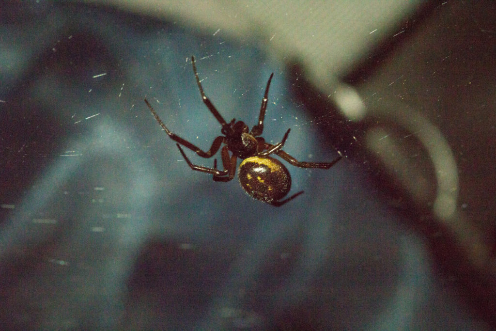
A false black widow, or Steatoda grossa, in our backyard shed. It scrambled for cover after this one shot.
OK — so that arachnid above got my attention when I went into our backyard shed this evening in search of WD-40 (exciting scenario, right?). I didn’t know what it was, and I’m always thinking I’m going to bump into a brown recluse. If you know what those look like — well, the specimen above isn’t remotely similar.
But it was dark and shiny, sort of like a black widow. Our neighbors believe they spotted one of those in their mailbox late in the autumn. But this spider tonight lacked the black widow’s distinctive red marking.
With that one photograph, I went online to see if I could find a match. This UC Berkeley page suggests it’s a false black widow, Steotoda grossa (you need to scroll down at that link to the seventh species listed).