
Last Christmas, I printed out a topographic map from a piece of software I have and traced out a map of the North Berkeley luminaria neighborhoods; I used different color inks to show the various years different blocks joined in. It’s not a presentation that translates to a digital format, so I’ve been thinking about how to do a map I could put online this year. There’s got to be something a semi-literate hack like myself can use to make a beautiful souvenir luminaria map; while I have faith that such a product exists, I haven’t found it yet. So back to the drawing board.
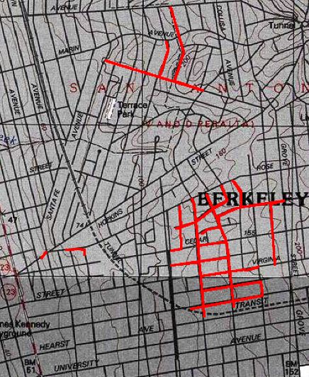
The map above is from the same software, Topo, that I used for my printouts last year. The streets that do the luminaria are traced in red using the software’s route tool. The big drawback to using the USGS maps for this purpose is that few streets are labeled. The resulting maps only make sense if you have an idea what you’re looking at to begin with.
My second option was to figure out how to present the luminaria using Google Maps. The maps are clear and easy to use and users can toggle back and forth between a regular street map and satellite pictures, or view a hybrid version. But making a Google Map from scratch using the available development tool would require more time to waste than even I have. So I decided to try to use an already-existing tool, the excellent Gmaps Pedometer, to trace out the luminaria street. As with the Topo versiion, that requires a lot of retracing to include every one of the contiguous blocks. But the result is pretty clear and you have the advantages of zooming in or out on the resulting map, and you have a very clear idea of what street is what. (Holly is in the northwest corner of the outlined luminaria streets). The biggest drawback is that the Pedometer doesn’t let you stop tracing in one spot and begin again in an unconnected spot. That means that I’ve left out several streets (shown in red on at the top of the Topo map above). This Gmaps tool also lacks any capacity (yet) for marking routes in different colors or for adding labels, so there’s no way of doing color-coding
So I’m playing with one more option: A site called MapBuilder.net that lets you build your own Google Map without recourse to any JavaScript or XML coding or access to a Web server to use the Google development resources. So what I came up with there is a Luminaria map (see if this link works: that highlights the chronology of the event (click on the arrow); and gives some idea of the geographic extent without showing all the streets involved. This is just a first try.
More later.
Love this. My siblings and I have been doing Virginia between McGee and Grant for the last several years. We’re at 1714 Virginia. Mom started making wasail to warm us up 2 years ago. Love this tradition! Thanks for the map!