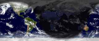
Strange to say "happy solstice," at least here in the northern hemisphere. Or maybe not — this is where things turn around and get brighter and brighter, right?
Anyway, I went looking for a site that might depict the light and dark areas of the Earth, reasonably sure that I’d find something interesting out there. And I wasn’t disappointed. The World Sunlight Map uses NASA, Defense Department, and weather satellite images along with geomapping software to render a current picture of sunlight and cloud cover all over the world. The picture above is today’s noon PST image.


Cool stuff. What does it say about you that you chose the rectangular projection instead of the Mercator or the Peters? Personally, I think anyone who doesn’t go the Peters route may be demonstrating latent fascistic tendencies, what with all the downsizing of Third World countries that goes on with the rectangular projection.
I actually like those projections that show the land masses in their true proportions. And the maps that put south at the top of the map. But I guess what I love most about the old projections is what they do to Greenland. I mean, it *is* actually pretty big. But when you Mercator it and put the Atlantic at the center of the map, it becomes the most important land mass in the world. No wonder the Vikings wanted it.
Greenland — definitely. I remember as a kid being impressed by it. Bigger than South America!