Road Blog: Hole in the Ground

holeintheground103013.jpg

A short post, since I’ve let it get so late: The next-to-last place we visited on our five-day Ice Age Floods Greatest Hits Tour was Hole in the Ground Coulee, just south of Cheney, the home of Eastern Washington University. Apparently, the area is called “Hole in the Ground” because of a 100-foot deep hole on the floor of the canyon here (one of Randy’s guidebooks says concerned locals filled it with rocks so no one would fall in).

The last stop we made, deep into the dusk, was at the site of a dry cataract not far from the site above, one of the many waterfalls that spilled flood waters south and east toward the Columbia basin when the Lake Missoula ice dams gave way far upstream.

Of course, touring the landscape created by the Big, Big Floods of Yesteryear was just part of what’s been happening the last five days. Randy and I were close during our teenage years — my shorthand for him is “my best friend from high school” — and we spent a lot of the time not filled with talk of lava flows, basalt configurations, receding cataracts, loess and loess islands, mesas, spires, potholes, craters, mima mounds, blades, benches, coulees, and the like reminiscing and catching each other up with what’s been happening in our lives.

It’s been a great five days. More pictures to come.

Road Blog: Potholes

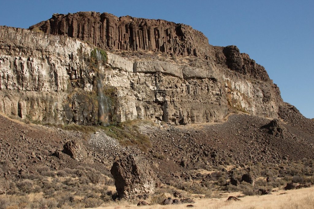
Basalt formations at Potholes Coulee, near Quincy, Washington.

Potholes, as in Potholes Coulee, part of the recently mentioned channeled scablands of eastern Washington. This was today’s main event, hiking up the one branch of the coulee — which I’ll describe as a valley about a little more than a mile and a half from west to east, surrounded on both the north and south by 300 foot rock walls. I’ll call it a valley, but it was actually an outlet for the big ice age floods that roared from northwestern Montana into the Columbia River basin.

The picture above (click for a larger version) is the north wall of this part of the coulee, which had waterfalls every few hundred yards. The wall consists of multiple layers of basalt from lava flows that occurred over a span of millions of years. That columnar structure high atop the wall (it is actually called a colonnade) and signifies the lower layer of a flow and one that cooled slowly compared to the irregularly fractured section above (called entablature). The lighter rock below is basalt from an earlier flow that spent some time underwater when a lake filled part of this valley.

At least that’s what I’ve absorbed over the last few days. And here’s a more scientifically grounded partial explanation, if you’re interested.

Me? I’m done. More later.

Road Blog: Extreme Geology

bankslake102713.jpg

That’s Washington state Highway 155, headed north from Coulee City toward Grand Coulee Dam. We got a gray, cool to cold day with a little autumn rain thrown in. The landscape is huge and surprising. To the right in this picture are basalt cliffs formed from successive lave flows over millions of years and then violently gouged out by the repeated great floods that poured through this region during the ice age. I heard an estimate somewhere today that about 520 cubic miles of water — cubic miles — came pouring across this part of eastern Washington in 48 hours. That’s a little less than the volume of Lake Michigan, which counts as a big lake in my book, discharged over a weekend. In the left of this picture in Banks Lake, a big reservoir created as part of the Bureau of Reclamation’s massive World War II era plumbing of this area. The huge mesa-like shape in the left distance is Steamboat Rock, once an island at the foot of an immense waterfall upstream. (Click the picture above for a larger image.)

Started: Moses Lake, Washington (7:15 a.m.)
McDonald’s breakfast to go
North on Washington 17 through Soap Lake
Stopped at Lenore Lake
Hiked up through canyon to Lenore Coulee and Great Blade
North on Washington 17 to Dry Falls State Park
Hiked up through notch in Umatilla Rock
Stopped at visitors center
Stopped in Coulee City; lunch at Last Stand restaurant and saloon
North on Washington 155 to Grand Coulee Dam
Stopped at Crown Point, overlooking dam and town, hiked to Candy Point
Stopped at dam visitors center
West on Washington 174 to Washington 17
South on Washington 17 to Washington 172
West of Washington 172 to U.S. 2
U.S. 2 to Wenatchee, Washington
Arrived: 7:30 p.m.

Road Blog: Scablands

scablands102613.jpg

The scablands–that’s what they call big pieces of eastern Washington, where I spent the day with one of my oldest friends, Randy Robinson. Roughly speaking, the scablands are the extensive rocky breaks in the rolling countryside in this part of the state. Mesas, tiered benches of basalt from ancient lava flows, gravel ridges, craters, the random distribution of huge boulders across the landscape. They’ve come to be known as the channeled scablands because of a reinterpretation of the regional geology in the 1920s that proposed that a flood of unimaginable proportions — set loose by the collapse of a colossal ice dam in western Montana, which in turn led to the sudden outflow of a huge mountain lake — scoured and sculpted the land maybe 15,000 years ago.

Anyway, that’s a summary of what Randy told me today, and we’ve got two or three or four more days of scabland hiking and sight-seeing ahead. (Where did the term scablands come from? I’m running it down — I find several references in the 1880s that apply that term to this part of Washington; I also found one possible reference from 1630s Britain that may indicate there’s an older and more general meaning of the term.

The picture above: One of our stops, a spot called Twin Lakes, west of Spokane. The challenge with this countryside is capturing something so big in any sort of meaningful way. Anyway

Riding the Rails

I was in in Washington (District of Columbia variety) for a work conference the last couple days. I was all set to fly to Chicago to visit the homeland when things wrapped up. But a little while after our meetings ended early this afternoon, I wondered whether I could take the trip by train instead. I checked Amtrak online, and the Capitol Limited–you don’t take it for granted these trains exist anymore–was scheduled to leave in about an hour. I thought it over for a few minutes as I had coffee with one of my San Francisco radio colleagues. The conclusion of my deliberations: Sure, why not? So I went and grabbed my suitcase from the hotel and walked down to Union Station. I bought a ticket on one of the sleeper cars, and now I’m nearly seven hours out of Washington and twelve from Chicago.

It’s my first overnight train trip since one I took in 1976 after an attempt to hitchhike from Berkeley to Chicago ended with an unfriendly encounter with police in Cheyenne, Wyoming. I decided to catch the train east from there, called my folks and had them wire the money for a one-way ticket. I hiked to the Western Union office, then the train station, and paid my fare. It had been a miserable road trip–rides few and far between and never really long enough to make a dent in the 2,000 miles I was trying to cover. And there was other unpleasant stuff I’ve kind of put out of my mind over the years. A scary ride ride with a couple of drunks who I was scared were too out of it to make the long plunging descent on Interstate 80 from Donner Pass to Reno. The guy who picked me up in Reno and became very threatening after I declined his invitation to come home with him. (Very threatening? When I insisted he let me out of his car–we were now near some desolate place about 10 miles outside town–he complied. But a few minutes later he stopped on the other side of the interstate and called out to me that he had a gun and was going to shoot me. Yeah–I ran down the embankment off the road as fast as I could and stayed there until I saw he was gone. But for the hour or so it took for someone else to stop out there, I expected every approaching car to be this guy coming back to get me.)

When I got on that train in Cheyenne, I was drained and decided I should have a beer. One beer in the middle of the afternoon. It knocked me out, and when I came to I was alone in a coach car, which was filled with a beautiful golden light from the setting sun. For maybe 30 seconds, I had no idea where I was or what I was doing on a train car. It seemed a lot longer. Then I put it together–this is the Chicago train, we’re stopped in Denver, and everyone else has gotten off to have a smoke or stretch or grab a cup of coffee.

This trip is tame compared to that. I’m sitting in the lounge car writing on my phone–Amtrak seems to be a WiFi-free zone, and this is the only way to post. I’m ready to turn in–that’s my mini railroad bunk in the picture. See you in the morning.


Riding the Rails

Road Blog: Oyster, Hero, Backhoe Man

oyster071313.jpg

A week ago, I was traveling down the coast of Washington with my brother Chris and nephew Liam. Just after sunset, we passed through a couple little towns in Pacific County, on U.S. 101 north of Astoria–first Raymond, then South Bend. Both are right on the Willapa River, just inland from Willapa Bay. As we rolled through South Bend, population 1,700, with Chris carefully watching how fast he was going in case of a speed trap, we passed a sign pointing to a launching ramp for kayaks and canoes. I glanced over and saw what appeared to be a giant shell with a sign that said “Worlds Largest Oyster.”

“Turn around,” I said to Chris as we rolled past. He pulled an apparently legal U-turn, and we drove into a little waterfront park. The “oyster” turned out to be made of concrete–maybe a draw for the rubes, of whom I had apparently proven myself one. The main display in the park turned out to be a memorial to a son of Pacific County, Robert E. Bush, who won the Medal of Honor as an 18-year-old Navy corpsman during World War II. In fact, there was a sign saying Mr. Bush, who did well in the lumber and building-supply business, had donated money for the park. He died in 2005, but there’s a small pavilion with a plaque inscribed with Bush’s Medal of Honor citation and a statue depicting Bush’s actions. Here’s the citation:

The President of the United States of America takes pleasure in presenting the Medal of Honor to Robert E. Bush, Hospital Apprentice First Class, U.S. Navy, for service as set forth in the following:

Citation: Robert Bush, United States Navy, for conspicuous gallantry and intrepidity at the risk of his life above and beyond the call of duty while service as Medical Corpsman with a Rifle Company, Second Battalion, Fifth Marines, First Marine Division, in action against enemy Japanese forces on Okinawa Jima, Ryukyu Islands, 2 May 1945. Fearlessly braving the fury of artillery, mortar and machine-gun fire from strongly entrenched hostile positions, Bush constantly and unhesitatingly moved from one casualty to another to attend the wounded falling under the enemy’s murderous barrages. As the attack passed over a ridge top, Bush was advancing to administer blood plasma to a Marine officer lying wounded on the skyline when the Japanese launched a savage counterattack. In this perilously exposed position, he resolutely maintained the flow of life-giving plasma. With the bottle held high in one hand, Bush drew his pistol with the other and fired into the enemy’s ranks until his ammunition was expended. Quickly seizing a discarded carbine, he trained his fire on the Japanese charging point-blank over the hill, accounting for six of the enemy despite his own serious wounds and the loss of one eye suffered during the desperate battle in defense of the helpless man. With the hostile force finally routed, he calmly disregarded his own critical condition to complete his mission, valiantly refusing medical treatment for himself until his officer patient had been evacuated, and collapsing only after attempting to walk to the battle aid station. His daring initiative, great personal valor and heroic spirit of self-sacrifice in service of others reflect great credit upon Bush and enhance the finest traditions of the United States Naval Service.

–Harry S Truman

Bush was one of the veterans featured in Tom Brokaw’s “The Greatest Generation.” He died in 2005, and is buried near South Bend. I see on Google Maps that U.S. 101 through the town is named after him. And so is a naval hospital in Twentynine Palms, in the Southern California desert.

There’s one other personal memorial in South Bend’s waterside park. And whereas you can easily track down the basics of Robert Bush’s life, buy his autograph on eBay, and find pictures of him receiving his medal from President Truman, I can’t find a thing about this second honoree. Here’s his marker:

backhoe071313.jpg

The text reads: “Burke J. Welsh, 1948-2005. Expert Backhoe Operator. South Bend Fire Department, 1975-1993. Lifetime Community Volunteer and Lifelong Friend.” That, and the fact folks in town thought enough of Mr. Welsh to remember him this way, is all I know about Mr. Welsh despite deploying my magical Internet skills (there’s a preview of my own someday plaque).

After we left the park, we saw that one of the local cops had pulled over a car–a gaudy PT Cruiser with British Columbia plates–about a block down the way. Always watch for that speed trap.
Restrooms & Cemeteries

roslyn053111.jpg

First morning of our recent road trip: We stopped in Roslyn, Washington, on the east side of Snoqualmie Pass and a few miles off Interstate 90. Reason: The town was re-created as “Cicely, Alaska” for the series “Northern Exposure” back in the early and mid-’90s. The main street in town, Pennsylvania Avenue, is much the same as it’s depicted on the show. Just in back of me when I shot this was The Brick, the tavern/restaurant featured on the show. The building across the way–the exposure here hides the details–was the location of the radio station on which the character Chris held forth. The sign pictured here? Never saw it in the show, and I can’t account for the pairing of restrooms and cemeteries.

Road Blog: Berkeley to Butte

packardpaha053111.jpg

This morning I took a 6:35 flight from Oakland to Seattle–the packed zoo-ish Southwest Airlines variety–then, in the company of my son Eamon and daughter-in-law Sakura, made a sharp right turn (if you’re looking at the map with north on top) and headed over the Cascades and well beyond on Interstate 90. We wound up in Butte at nightfall. I figure the day involved about 750 air miles and another 600 on the road. All set up with two hours of sleep, the result of a push to get some work done yesterday evening. That seems like a long time ago.

From out of the overload, one image that there’s no picture for: a pair of sandhill cranes winging across the Interstate, somewhere in that last hour on the road, an apparition in the long light of the last day of May, after crossing the Cascades, the Palouse, the first low passes of the Rockies, with rivers in every valley running full, the higher peaks all gleaming mid-winter white. Kind of hard for me to figure what season we’re in. The cranes have a bead on it, though.

Tomorrow? There’s talk of the Little Big Horn and Deadwood. We shall see.

Two much more prosaic snapshots go into the book for today, though. Above: On the Palouse, west of Spokane. Below: Serious advice from the state of Washington for a certain class of drivers and their friends.

notaurinal053111.jpg