
Well, it’s here. Rain, I mean. Not in copious, toad-strangling, gully-washing volumes. And I just heard a National Weather Service forecaster on the radio counsel patience — more will be coming later today, overnight, tomorrow. As I said the other day, we’ll take what we can get. In drought times, and even just at the end of our long summer dry spells, water falling from the sky carries an emotional weight way out of proportion to what shows up in the rain gauge.
Dog on the Couch

Yeah, we’re one of those outfits — we let The Dog get on the furniture. And here he is today, Day Four of the Return of Winter to the Bay Area. It seems that every time we’ve been out since Wednesday evening it’s been wet. He actually seems to enjoy the weather and the process of us toweling him off before we come inside again. But he does a great impression of a sad dog in the too-long intervals between walks. For extra points, he somehow splays his front paws in opposite directions.
Rain, 2014 Style

There it is: what you might refer to idiomatically as the sum total of Berkeley rainfall — or at least the rainfall we have seen here in the North Berkeley flatlands — for the entire month of January so far. When the drizzle started coming down last Saturday, I grabbed the camera and ran out to take a picture. It was just enough to moisten the pavement or the bottom of a rain gauge or, as above, to bead up on windshields.
And from what the weather forecasters, the paragons of prognosticatory pessimism, are saying, this is the only rain we can expect to see through the end of the month. Which means we’re starting 2014 with the driest January on record. Here’s a brief synopsis of where the rain season stands from the National Weather Service’s Bay Area forecast discussion:
SAN FRANCISCO`S CURRENT WATER YEAR TOTAL IS 2.11" WHICH IS NOW THE
THE DRIEST WATER YEAR TOTAL TO DATE ON RECORD. THE OLD RECORD WAS
2.26" THROUGH JANUARY 15TH SET BACK IN 1917. SAN FRANCISCO IS
RUNNING AROUND 9" BEHIND AN AVERAGE YEAR. IF NO ADDITIONAL RAINFALL
IS RECORDED BY THE END OF THE MONTH, SAN FRANCISCO WILL BE 11.50"
BEHIND NORMAL.
SAN FRANCISCO AVERAGES AROUND 8 DAYS IN JANUARY WHERE MORE THAN A
TENTH OF AN INCH OF RAINFALL IS REPORTED. THIS YEAR WE HAVE HAD
ZERO DAYS SO FAR. IF THAT HOLDS, IT WILL MARK THE FIRST TIME IN SAN
FRANCISCO`S HISTORY THAT AT LEAST ONE DAY IN JANUARY DID NOT PICK
UP MORE THAN A TENTH OF AN INCH.
And that, friends, kinds of puts things in perspective. What we’re seeing now hasn’t been seen since 1849, the beginning of San Francisco’s rain record.
Local and Regional Weather, Part 2
The day began with rain, and with rain it ends. A sort of anemic late-season storm arrived before dawn and then parked. Even a weak little storm will get you wet when it decides not to move on. I can hear rain on the roof and running down the drainpipes. At the other end of the house, I can hear the TV weather guy talking about the rain continuing. I’m thankful for a dry space to sit and listen.

Rain, If You Look Hard Enough

There it is, that drop of water right there at the end of that little clear holiday lightbulb–evidence of our big New Year’s Weekend rainstorm. Somewhere far to the north, it’s really been coming down the last couple of days. A favorite weather-table wet spot, Red Mound in the southern Oregon Coast Range, has probably picked up half a foot of rain or more. Here, we’re measuring the wet in hundredths of an inch: .01 in San Francisco, .05 on the top of Mount Diablo. Up in the middle of Mendocino County, Boonville got a real soaking: .11. At the north end of the Napa Valley, Mount St. Helena got .16–a full sixth of an inch. And so ends one of the dryest Decembers since the new arrivals in the area started measuring such things a bit more than a century and a half ago.
After this torrent blows through, the next chance that rain will fall within 100 miles of us here in Berkeley is about the middle of next week; and right now, it looks like it might not be much closer than 100 miles.
Hey, Rainmaker
A dry summer, and then comes the fall
Which I depend on most of all.
Hey rainmaker can you hear the call?
Please let these crops grow tall.—The Band, “King Harvest”
We had some rain overnight–just enough to keep the dust down, if there had been any dust (we did have plenty of crap in the air, though: a miasma of car exhaust, smoke, and other metropolitan exhalations that led the regional air district to ban wood fires for four days in a row). The “storm” total in San Francisco for the rain that started falling last night is .04 of an inch–four-hundredths–and according to the National Weather Service is the first rain since we got .21 of an inch on Thanksgiving.
Meantime, continuing my claim to be the first in my neighborhood to express precipitation anxiety this year, the state Department of Water Resources and its California Data Exchange Center are out with their latest summary of hydrologic conditions for the state. Here’s my summary of their summary: November 2010 was wet, November 2011 was dry. Or in the summary’s own machete-proof prose:
On November 30, the Northern Sierra 8-Station Precipitation Index Water Year total was 6.5 inches, which is about 70 percent of the seasonal average to date and 13 percent of an average water year (50.0 inches). During November, the total precipitation for the 8-Stations was 2.6 inches, which is about 41 percent of the monthly average. Last year on November 30, the seasonal total for the 8-Stations was 15.5 inches, or about 167 percent of average for the date. On November 30, the San Joaquin 5-Station Precipitation Index Water Year total was 4.0 inches, which is about 59 percent of the seasonal average to date and 10 percent of an average water year (40.8 inches). During November, the total precipitation for the 5-Stations was 1.5 inches, or about 32 percent of the monthly average. Last year on November 30, the seasonal total for the 5-Stations to date was 14.4 inches, or about 212 percent of average for the date.
Of course, one or two good drenchings will make all this early-season anxiousness go away.
Related:
It’s December. Do You Know Where Your Rain Is?
KQED: California Reservoir Watch
It’s December. Do You Know Where Your Rain Is?

It’s December now in the Bay Area, and if you’re fastidious about your weather expectations, you look out the window and want to see rain. Or at least a little gray. But in the wake of the little wind event of the past couple of days, what I see out there is a sparkling azure sky without a hint of a cloud.
Our climate is mostly dry from sometime in April to sometime in October, mostly wet from October to April, except when it’s not. And when it’s not, we’ve got trouble. Yes, things in the cities are beautiful, and when you turn on the spigot, water from somewhere magically appears. But you know that somewhere–up in the Sierra, out in the Valley–things aren’t so good. There won’t be enough mountain snow to help replenish the reservoirs in the spring. The farmers will want water they cannot get. The fish and wildlife that depend on an abundant flow of water through the Delta, species threatened because for decades they were last in line when people thought about how to spend the water we bank, will suffer. The edge to the anxiety comes from the knowledge that drought happens here, and drought can become a social and political as well as a natural and environmental mess.
Feeling nervous yet? I am. I follow Jan Null, a Bay Area meteorologist. Here’s his climate summary for last month:
November 2011 was a cool and mostly dry month across California. Monthly average maxima anomalies were -1.0 (San Jose) to -3.6 degrees (Los Angeles), while monthly mean anomalies were -0.8 to -2.3 degrees. North of the Tehachapis rainfall was well below normal ranging from 28% of normal (Sacramento) to 69% (Eureka) while Southern California was quite wet with Los Angeles and San Diego at 152% and 309% of normal respectively.
Sometimes, to reassure myself that all will soon be well, I might take a spin through weather and climate sites to see what the professionals are saying about the forecast. That image to the right is a graphic of the Quantitative Precipitation Forecast from the California Nevada River Forecast Center. During a wet period, the map will be a glorious swirl of color–blue and green and yellow, depicting progressively heavier precipitation, and sometimes orange and splashes of red and magenta when it’s really wet (there’s a scale at the top of the map; click on the image for a full-size version). Gray, on the other hand, means dry. No rain in the lowlands. No snow in the uplands. No reassurance.
Next, here’s how one of the meteorologists down in the Bay Area National Weather Service office in Monterey sums up the coming week in the Area Forecast Discussion (using familiar all-caps weather advisory style):
DRY WEATHER LOOKS TO BE IN STORE FOR THE DISTRICT SUNDAY THOUGH NEXT WEEK. HOWEVER…THE MODELS ARE STARTING TO SHOW SOME DIFFERENCES. THE ECMWF KEEPS A STRONG RIDGE ALONG 135W STRETCHING INTO THE GULF OF ALASKA WITH A STRONG SHORTWAVE DIVING DOWN THROUGH THE GREAT BASIN LATE THURSDAY INTO FRIDAY. THIS SCENARIO WOULD BRING ANOTHER BOUT OF GUSTY OFFSHORE WINDS. THE GFS WEAKENS AND FLATTENS THE RIDGE BY THE END OF NEXT WEEK…WITH A SHORTWAVE MOVING INTO THE NORTHERN PLAINS NOT DIVING SHARPLY SOUTHEAST. THIS WOULD NOT BE A WINDY SCENARIO FOR THE DISTRICT. REGARDLESS OF THE MODEL…DRY WEATHER IS IN STORE THROUGH THE END OF THE NEXT WORKWEEK.
Got that? The major question the weather persons are dealing with is whether or not the forecast models indicate another windstorm for the coming week. Chances of rain–none apparent.
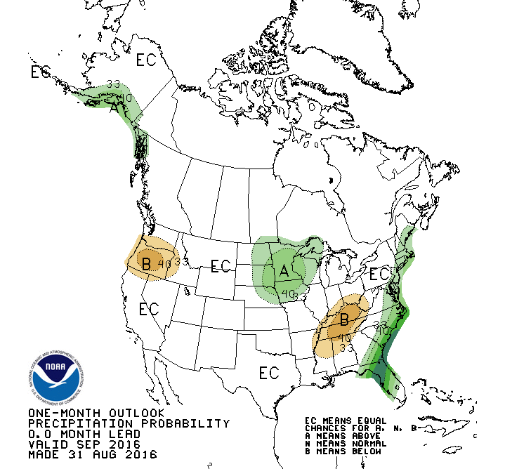
The pluviophile now turns eyes to the coming month, even though we’re exiting the realm of forecasting and prediction and entering into one of probabilities and outlooks. But here goes: The National Weather Service Climate Prediction Center says the Bay Area should have “near median” precipitation in the period from eight to 14 days from now (median in this case meaning rainfall along the lines of the “middle 10 years” of the past three decades in terms of rainfall); the northern quarter of California is looking at below-median rainfall during that period. The center’s one-month outlook shows equal chances of above, below, or near median precipitation. That’s because “there were no strong and consistent climate signals” among the forecast models.
And one last stop: Both the most recent U.S. Drought Monitor report and the seasonal outlook, through the end of February, show California drought-free (things look scary in Texas, though).
So where’s the rain? Like that TV show used to say: Out there. Somewhere.
Coming Attractions: Autumn Rain

There it is: our first storm of what we’d like to call our rainy season (the live version of the image is here). The National Weather Service has been advertising this as a “rather weak” system that won’t drop much rain here. Maybe so, but the radar image–which doesn’t always depict what’s out there in the atmosphere–seems to indicate some moderate to heavy precipitation off the coast. We’ll see in the next few hours.
Tax Night Drizzle

Just came in from The Dog’s nightly patrol. It’s been drizzling since late afternoon. I wondered what kind of picture you might get if you pointed a light–in this case, an LED headlight–up into the rain with the shutter open for 10 seconds. This is the answer. The orange hue suffusing everything is from the city lights; the blueish filaments are the drizzle coming down. I once saw a monster “flashlight” in a Restoration Hardware catalogue; it was actually a portable, battery-powered spotlight that you could probably use in an operating theater (although I think it could run on maximum power for only 20 minutes or so). I’ve fantasized about having one of those lights as an attention-getter. To light up some driver blowing through a stop sign at night, say. But I’d like to try the drizzle experiment with one, too.
Storm Week, Potrero Hill
At the foot of the pedestrian overpass that cross U.S. 101 from 18th and Utah (west side of U.S. 101) to 18th and San Bruno (east side of the freeway). I was on my way into work. Can’t remember if this was the day I locked my keys in the car (Triple A came and got them for me), or the day I jump-started a coworker’s car (she had left her lights on), or the day I had delivered another coworker’s purse after she forgot it at work. The only thing I know for sure is that we had rain this day, like every other day of the week. Below: U.S. 101, looking south from the pedestrian overpass toward Bernal Heights (Utah Street turning west into 18th Street below and to the right).
