Descanso: Highway 128

Yesterday, we attended a memorial for a friend up in Davis. It was a Quaker-style remembrance, where the three dozen or so people in attendance were invited to share their stories about the departed. Most of the stories were quite surprising to me — I learned a lot about this person’s life I really had no clue about, though we’d known each other since before high school. There was a lot to process.

I was really at loose ends afterward and just felt like a drive. So we set out. I have to say here that Kate, my wife and frequent exploration partner, did the greatest thing: She didn’t ask once where we were headed. We were just going, heading west, enjoying the light of a beautiful October afternoon.

I got to know the backroads in this part of the world — the western edge of the Central Valley, the hills and mountains on the way to the coast, Yolo and Napa counties, among others — while doing long-distance bike rides from the late ’80s through about 2010. So that led me toward Winters, a little valley town west of Davis, and up Highway 128 past Monticello Dam. This slice of countryside is much different from my riding days. Much of it has burned at least once in the past decade, with the greatest acreage by far incinerated during a series of lightning-sparked fires in the summer of 2020. Now, huge swaths of the landscape are marked by the skeletons of burned oaks and laurels and I don’t know what else. It is stark and sobering.

A roadside memorial on Highway 128 southwest of Monticello Dam in Napa County. It reads: “Rojo. Descanza en Paz. 03 21 2021.”

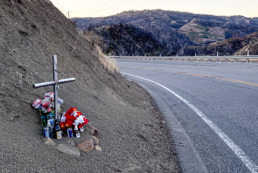
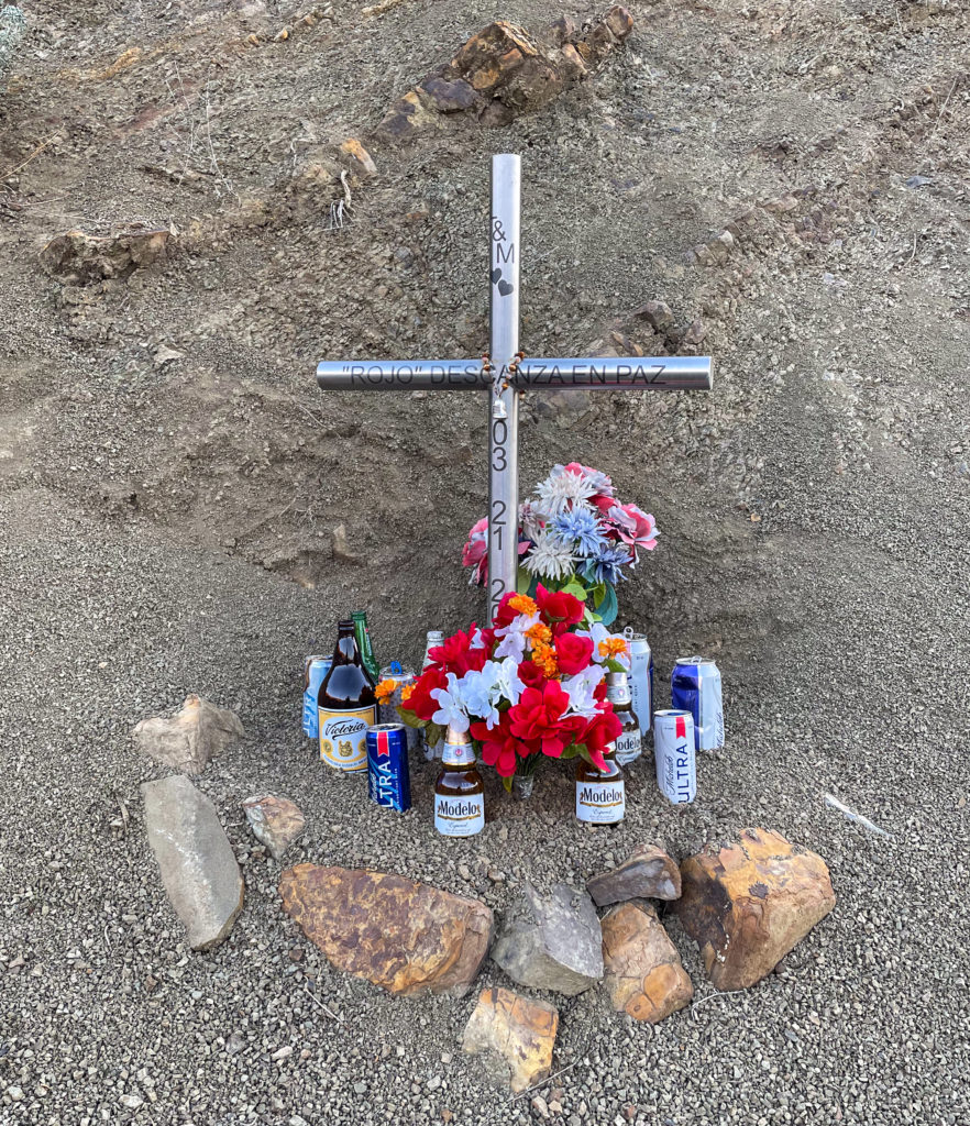
A few miles past the dam and a little resort called Markley Cove, we happened across this cross. There’s a good pullout a hundred yards or so down the road, so I stopped. But it’s at a tight spot on a curve with limited visibility for both drivers and anyone foolish enough to walk on the side of the road where the cross was erected. Kate was a little dubious of me going over to photograph it; she had a view around the curve and said she’d honk if cars were coming.

As it happened, after I took this shot, I could hear the sound of a car approaching … from somewhere. I didn’t hear the horn honk, so I started out into the road. Looking to my left, two or three cars were approaching. Not bearing down on me, exactly, but close enough that I felt I needed to hurry up across the road. I guess one of my ambitions in life is to not have one of these markers put up in my memory.

As to the person memorialized by this marker, here’s a snippet from the Napa Valley Register of March 21, 2021:

“A fatality was reported Sunday evening after a collision involving a motorcycle and another vehicle in the Lake Berryessa area, according to the California Highway Patrol. …

“A passenger on the motorcycle suffered minor injuries, as did the driver of the other vehicle. … The name of the motorcyclist was not immediately available.”

The CHP’s report includes a few more details: The motorcycle was headed west when it crossed the highway’s centerline and sideswiped on oncoming pickup truck. The motorcycle driver was 29 years old. It’s not lost on me that the date of the crash inscribed on the cross, March 21, was the birthday of the friend whose memorial we were attending.

As the cross in the picture says, “Descanza en paz.”

Day Trip

road152511a.jpg

I took yesterday off. So did Kate. We did a mini-road trip to Mendocino County with The Dog. Though it’s late May, and we like to think we ought to be well into the dry season, it rained on the way north and then sporadically all day. Beautiful, though. And we were home by dark.

Above: That’s looking “southbound” (actual direction may be east) on Highway 128, along what I think of as the “true summit” area just north of the Sonoma-Mendocino county line. Heading north, you climb a grade of about two miles or so and are briefly rewarded with the impression that you’ve reached the top as you head down a little descent. Then the road pitches up sharply again before you cross a higher crest and start downhill toward Mountain House Road, which connects to Hopland. This Interesting aspect for me of driving roads in this area is that I’ve ridden them in all sorts of conditions, dry, wet, in the middle of the night. The constant: I’m usually pretty tired, because this stretch of Highway is located deep into some long brevet routes I’ve done–better than 100 miles into most, more than 200 miles into a couple of them.

Below: mini-slideshow of scenes from the highway.

Long-Distance Riding: Behind-the-Windshield View

We drove up to Mendocino over the weekend using the easy route from the East Bay: U.S. 101 through Marin and Sonoma counties to Highway 128 in Cloverdale, out 128 to the coast and Highway 1, then up 1.

We weren’t in a big hurry, so we decided to stop in Cloverdale, the last town in Sonoma before you reach the Mendocino County line. The last several times I’ve been up there, I’ve either been on a bicycle or have been supporting someone else’s ride. In 2007, I remember going through Cloverdale twice: late at night near the northern end of a 400-kilometer brevet, shepherding a semi-lost and semi-lightless rider, then again passing through both ways on a rainy 600-kilometer brevet (I got doused on the way north; by the time I came back the next morning, the weather had turned and it was sunny and warm and a big tailwind was building–I smile just thinking of it).

All by way of saying that when we spotted several bikes at the gas station/convenience mart at the south end of town, it took me about five seconds to figure out I was looking at people on a brevet (the combination of the gear on the bikes and some of the jerseys–a California Triple Crown and a San Francisco Randonneurs–tipped me off). I asked and found that the riders were out on a 400-kilometer brevet from the Golden Gate Bridge up to Hopland. From where I met them they had something like 30 kilometers to the turnaround point and several hours of beautiful March weather to enjoy before the night leg back to San Francisco. On the way out of town and all the way up the long climb on 128 to Mountain House Road–the beautiful (and roughly paved, last time I was there) back-country link to Hopland–we passed riders plugging away in ones and twos.

Did I wish I was out there myself? No–not in my current non-riding shape. But I did have an audio recorder with me and considered for a minute whether I might wait at the top of the grade to talk to the riders coming past. Didn’t do it, though. I did give a wide berth and a wave to all the riders we saw. Bonne route, boys!

***

Coming back from Mendocino, we made the counter-intuitive move of starting the southward trip by driving north along the coast out of Fort Bragg on Highway 1, then crossing the Coast Range to Leggett, where we could pick up 101 south.

I’ve never ridden this stretch of road, but have driven it three or four times. In my memory, the stretch from the coast had organized itself into a long, straightish section from Fort Bragg to point where you turn east, then a long climb up the mountains and equally long descent to Leggett, an old, broke-looking logging town that boasts a famous massive drive-through redwood tree. What I saw yesterday was a little different from what I remembered. The section north of Fort Bragg was neither as straight nor as level as I remembered. Heading up the highway, you turn inland quite abruptly; as you leave the coast, what look like trackless mountains stretch away to the north, falling straight into the sea. The climb and descent to Leggett turns out to be two ascents and two downhills with a bit of mostly level road between them. Driving it, I was reminded of friends who had done a 24-hour Easter weekend ride back in 2004, starting in Leggett and ending in San Francisco. What a way to start out.

We had no traffic behind us all the way across the climbs, so I didn’t have to push my speed or pull over. When we had descended nearly to Leggett and it had started to rain, we spotted a single cyclist starting up the grade. I slowed to encourage him, and he stopped to talk. I wished I’d gotten his name: He was loaded for a tour down to San Francisco and was figuring on doing 60 miles a day to get there. He looked like he was prepared for weather, and I think he’ll see some this week with a series of storms expected on the coast.

Did I wish I was out there? Kind of, though my last long ride in the rain isn’t filled with fond memories. Instead of pondering that, we drove home. Total mileage for the weekend, about 29 hours on the road, was 380 miles. I did reflect briefly that during that 600-kilometer ride in 2007, I rode 375 miles in about 36 hours — including six hours off the road to eat and sleep in Fort Bragg. I’ll probably remember that weekend, at least the road part, longer than I remember the driving I did this time around.

Long-Distance Cycling: Behind-the-Windshield View

We drove up to Mendocino over the weekend using the easy route from the East Bay: U.S. 101 through Marin and Sonoma counties to Highway 128 in Cloverdale, out 128 to the coast and Highway 1, then up 1.

We weren’t in a big hurry, so we decided to stop in Cloverdale, the last town in Sonoma before you reach the Mendocino County line. The last several times I’ve been up there, I’ve either been on a bicycle or have been supporting someone else’s ride. In 2007, I remember going through Cloverdale twice: late at night near the northern end of a 400-kilometer brevet, shepherding a semi-lost and semi-lightless rider, then again passing through both ways on a rainy 600-kilometer brevet (I got doused on the way north; by the time I came back the next morning, the weather had turned and it was sunny and warm and a big tailwind was building–I smile just thinking of it).

All by way of saying that when we spotted several bikes at the gas station/convenience mart at the south end of town, it took me about five seconds to figure out I was looking at people on a brevet (the combination of the gear on the bikes and some of the jerseys–a California Triple Crown and a San Francisco Randonneurs–tipped me off). I asked and found that the riders were about nine hours out on a 400-kilometer brevet from the Golden Gate Bridge up to Hopland. From where I met them they had something like 30 kilometers to the turnaround point and several hours of beautiful March weather to enjoy before the night leg back to San Francisco. On the way out of town and all the way up the long climb on 128 to Mountain House Road–the beautiful (and roughly paved, last time I was there) back-country link to Hopland–we passed riders plugging away in ones and twos.

Did I wish I was out there myself? No–not in my current non-riding shape. But I did have an audio recorder with me and considered for a minute whether I might wait at the top of the grade to talk to the riders coming past. Didn’t do it, though. I did give a wide berth and a wave to all the riders we saw. Bonne route, boys!

***

Coming back from Mendocino, we made the counter-intuitive move of starting the southward trip by driving north along the coast out of Fort Bragg on Highway 1, then crossing the Coast Range to Leggett, where we could pick up 101 south.

I’ve never ridden this stretch of road, but have driven it three or four times. In my memory, the stretch from the coast had organized itself into a long, straightish section from Fort Bragg to point where you turn east, then a long climb up the mountains and equally long descent to Leggett, an old, broke-looking logging town that boasts a famous massive drive-through redwood tree. What I saw yesterday was a little different from what I remembered. The section north of Fort Bragg was neither as straight nor as level as I remembered. Heading up the highway, you turn inland quite abruptly; as you leave the coast, what look like trackless mountains stretch away to the north, falling straight into the sea. The climb and descent to Leggett turns out to be two ascents and two downhills with a bit of mostly level road between them. Driving it, I was reminded of friends who had done a 24-hour Easter weekend ride back in 2004, starting in Leggett and ending in San Francisco. What a way to start out.

We had no traffic behind us all the way across the climbs, so I didn’t have to push my speed or pull over. When we had descended nearly to Leggett and it had started to rain, we spotted a single cyclist starting up the grade. I slowed to encourage him, and he stopped to talk. I wished I’d gotten his name: He was loaded for a tour down to San Francisco and was figuring on doing 60 miles a day to get there. He looked like he was prepared for weather, and I think he’ll see some this week with a series of storms expected on the coast.

Did I wish I was out there? Kind of, though my last long ride in the rain isn’t filled with fond memories. Instead of pondering that, we drove home. Total mileage for the weekend, about 29 hours on the road, was 380 miles. I did reflect briefly that during that 600-kilometer ride in 2007, I rode 375 miles in about 36 hours — including six hours off the road to eat and sleep in Fort Bragg. I’ll probably remember that weekend, at least the road part, longer than I remember the driving I did this time around.