Back in August, I took a drive along some rural roads in Yolo County, on the edge of the Sacramento Valley, that I’d become familiar with on long bike rides 15 and 20 years ago. Most of the county is on the flat floor of the valley and was given over to agriculture — crops that even a city dweller like me could identify on the move included rice, sunflowers, alfalfa, tomatoes. Some nut and fruit orchards, too. That’s still a lot of what you see.
Northern and western parts of the county are hilly, though, and when I’d ride through, most of those areas appeared to be used for pasture with the occasional appearance of a grain crop wrapped around the hills’ contours.
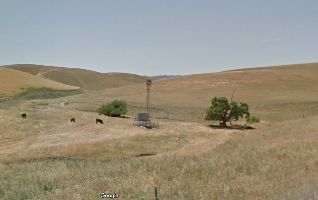
In August, I was surprised to find that a lot of that former pastureland has been transformed into what I assume are almond orchards. I drove past a spot where, long ago, a couple of other cyclists and I had taken a break from riding against a fierce north wind. Back then, in 2006, it was a big open field with some abandoned-looking farm equipment that we ducked down behind to get out of the wind. Now that spot is all nut trees.
I stopped to take pictures along one of the routes I traveled, Road 6. Looking at the result — it’s the black and white shot below, which I just had developed — I realized that maybe Google Streetview would show the same scene over the years. The most recent shot Google has is from May 2012. Here’s a little of what the change looks like (and a before/after slider of the scene is here).
Along Road 6 in the Dunnigan Hills, Yolo County, May 2012. Credit: Google Streetview.Along Road 6 in the Dunnigan Hills, Yolo County, August 2022. Credit: Dan Brekke.
The transformation is not shocking; it’s part of the vast expansion of almond and pistachio acreage that’s overtaken much of the Central Valley.
If you live here, the puzzling thing about this changed landscape is that the last decade is one of the driest periods, if not the driest, since California was colonized 250 years ago. The state’s water supplies are dwindling, a situation that’s supposed to become more challenging as the effects of climate change accelerate. Given that there’s not a lot of visible irrigation infrastructure here, I assume that water is being pumped out of the ground to support these thirsty orchards. I haven’t looked into who the adventurous growers or hedge-fund investors are who have launched this experiment in the middle of our drought. It’s quite a gamble.
Well, it’s here. Rain, I mean. Not in copious, toad-strangling, gully-washing volumes. And I just heard a National Weather Service forecaster on the radio counsel patience — more will be coming later today, overnight, tomorrow. As I said the other day, we’ll take what we can get. In drought times, and even just at the end of our long summer dry spells, water falling from the sky carries an emotional weight way out of proportion to what shows up in the rain gauge.
7-6-21: Continued hot weather above 100 degrees for periods in late May, early June and past two weeks continuously will lead to depletion of cold water pool in Shasta Lake sooner than modeled earlier in season. This hot weather is leading to more demand downstream for water (flows from Keswick Dam from 8,500 to 9,250 cubic feet per second on July 4th). Previously modeled season long cold water availability scenarios used steady flows in the 7500 cfs range from Keswick. Those earlier scenarios had very high expected juvenile mortality due to warm water later in August-October that would be lethal to incubating eggs and alevins in the gravel. This persistent heat dome over the West Coast will likely result in earlier loss of ability to provide cool water and subsequently it is possible that nearly all in-river juveniles will not survive this season. Counts of carcasses continue to indicate a large run of winter-run this year. Unspawned fresh females for the season are 71 with an overall percentage of 12.3% of all fresh females this season were unspawned.
If you are looking for a quote for a story, consider this one from me:
“Californians should be alerted that the extinction of a native salmon run is underway right now as a result of government inaction to stop it. State and federal water managers have apparently decided it’s politically inconvenient to reroute short water supplies to prevent extinction if it means a few less acres of crops. We’re losing winter run salmon right now and the fall run salmon that supply the sport and commercial fisheries will be decimated too. Californians who care about the environment need to hold government officials accountable for allowing the loss of the state’s natural resources on their watch.”
In our last installment, we were taking in the sights of Lake McClure just as night fell. Now, let’s reverse gears and go about an hour or so backwards, when I arrived at Lake Don Pedro — on the Tuolumne River east of Modesto — after an afternoon of noodling around near downtown Modesto (photo subjects: church, train station turned bus depot), Roberts Ferry Cemetery (graves) and numerous pretty spots along Highway 132, aka The Unknown (to Me) Highway, to look at trees, hills, rocks and clouds.
Highway 132, which heads east from Interstate 580 south of Tracy and goes through Modesto (city) and Empire, Waterford and LaGrange (town, town, hamlet), is the perfect route if you want to see two of California’s biggest reservoirs because a) the lakes almost touch each other and b) the road runs right between them. Here’s the map:
So I thought that I’d drive up there and see both drought-reduced lakes and, if I managed my time wisely, have time to get to a third a little further north, New Melones Reservoir, on the Stanislaus River. That was too big an if. I took it easy Sunday morning, found a few chores to do, sat and thought about it a little while, considered what a beautiful day it was, checked the time of sunset, saw that it was almost exactly 6 p.m., then finally, about 1:30.
I will say this: The light was beautiful all the way out of the Bay Area, across the Central Valley and into the foothills. As I drove out there, I wondered whether I would have enough time to happen across anything that would say anything unique about each lake. After awhile, the once-drowned, now-denuded reservoir landscape takes on a certain sameness: the red earth, the bare slopes showing the lines of the receding lake, the out-of-commission boat ramps, the house boats confined shrinking bays.
When I finally got to Lake Don Pedro — according to a credible-sounding history, it’s named after a Frenchman, Pierre Sainsevain, who came to California in the 1830s, became naturalized as a Mexican citizen, and was granted land near Santa Cruz as Don Pedro before heading to the Sierra foothills during the Gold Rush — it was 5:30 and the shadows were getting pretty long. I shot a few pictures (a couple of them are posted here). It felt haphazard. I wasn’t able to frame anything really different from what I’d seen at, say, Lake Oroville.
Then I headed to Lake McClure, But we’ve already been there, blogwise. It happened to be a more dramatic spot, the lake is much lower than Don Pedro, and the just-after-sunset light there added a dramatic element.
One other thing to note here about the appearance of the lakes in these two posts:
Lake Don Pedro is a big reservoir, with a capacity just over 2 million acre-feet. It’s 43 percent of capacity right now, and its surface elevation is 710 feet above sea level. That’s 120 feet below its “full” elevation, 830 feet. Lake McClure is about half the capacity of Don Pedro, and is currently at just 9 percent capacity. Its surface elevation is currently 605 feet — 274 feet below it’s brim-full level.
Here’s a shot (click for larger image) from my flight to Chicago last week as the plane headed northeast toward the north end of Lake Tahoe. That’s French Meadows Reservoir, on the Middle Fork of the American River, at the top, Hell Hole Reservoir, on the Rubicon River, at the bottom.
Both reservoirs are at about 25 to 30 percent capacity; Hell Hole is at about 50 percent of its average level for this time of year, French Meadows is at about 66 percent average. Both are operated by the Placer County Water Agency, which supplies or sells water to in much of the Sacramento metropolitan area and northeast along the Interstate 80 corridor.
Besides the signs of drought in the image, one other notable feature: the brown area to the lower left and between the two reservoirs is part of the 97,000 acres burned in the King Fire in September.
The further adventures of a California reservoir. A year and a week ago — late March 2013 — Kate and I camped in the very nice Loafer Creek campground at Lake Oroville State Recreation Area. The lake, the main reservoir for the State Water Project and the second largest California reservoir after Lake Shasta, was about 85 percent full at the time. If you were following the vagaries of the state’s water season, you might have been a little troubled by the fact the 2012-13 rains had virtually disappeared after the turn of the new year. What wasn’t apparent during the first visit up there was that the rains wouldn’t return in the fall, either, and that the lake would fall to just one-third full by January — low in any season, but especially alarming in that the reservoir levels here and virtually everywhere else across the state continued to decline at a time when they’d usually be filling up with runoff from winter storms.
I drove up to Lake Oroville on January 18, which happened to mark the lake’s low point during the current water year (July 1, 2013-June 30, 2014). The difference in the lake’s appearance was dramatic — see the slideshow below. But when seasonal rains finally returned in early February, the lake began to rise. One way of measuring lake level is the height of the lake surface above sea level. When full, Lake Oroville’s surface is 900 feet above sea level. When Kate and I visited in March 2013, the surface level was 860 feet; when I went back in January, it stood at 701 feet according to the numbers from the state Department of Water Resources. The same source shows the lake at 759 feet now and rising.
Yesterday, Thom and I drove up to Oroville to take a look and take a new set of pictures to show the change since January (they’re incorporated into the slideshow). My impressions:
I suppose this is a “glass half-full/half-empty” exercise on a grand scale, especially since the lake is at almost exactly 50 percent of its total capacity right now. On one hand the lake is up almost 60 feet from the last time I saw it and has added about 40 percent to its storage — it’s added about 500,000 acre-feet since January, enough water for about 1 million California households. More water is coming, too: Even though the forecast for the next couple of weeks and beyond looks pretty dry, and even though we’re nearing the tail end of the rainy season, the snowpack will start too melt and run down the branches of the Feather River that flow into the lake.
The conventional wisdom is that half of the state’s stored water is captured in the Sierra snows that wind up in streams, rivers and reservoirs. One slice of Lake Oroville history shows how dramatic an impact the snowpack can have:
A drier-than-normal water year in 2008-09 reduced the reservoir’s storage to a shade more than 1 million acre-feet, less than 30 percent of capacity, and lowered the surface to 665 feet above sea level by early January 2009; that’s about 20 percent less water and about 45 feet lower than the level we saw this past January. Then storms began arriving and began building the northern Sierra snowpack. The water content of the snow in the Feather River drainage reached about 130 percent of normal by early April 2010, and the lake had come up to virtually the same level as it is this weekend. The reservoir, which had reached its lowest point on January 11, kept rising through June 29, when it reached its high point of about 2.7 million acre-feet and elevation of 843 feet above sea level. That’s a rise of 178 feet in less than six months.
So that’s the glass half-full. It’s normal for our reservoirs to rise and fall, often dramatically (and no, I’m not addressing here the impact of how the reservoirs are operated — how much water is released, when, and why).
Here’s the empty half of the glass for Lake Oroville: This year, the Department of Water Resources estimates that the water content in the thin layer of snow in the Feather River watershed’s high country is just 13 percent of average for this time of year. Thirteen percent. So, we’re not going to see any late season rise in the lake. More likely, we’ll see a scenario more like the one that unfolded in 2007-08, when two drier-than-normal years left the lake at close to the same level we see today — 753 feet. The watershed’s snowpack was lower than normal, and although runoff gave the lake a boost, it topped out at just 760 feet and 50 percent capacity in late May. That dry rain year was followed by another, and in February 2009, the state declared a drought emergency.
None of this is meant to make a single reservoir, even a big one like Lake Oroville, seem more important than it really is. But reservoirs are important to making it possible for 38 million people to live, and for a rich agricultural industry to thrive,in a place where it typically doesn’t rain much for six months of the year. And Lake Oroville’s water storage happens to mirror what’s happening with the state’s water supply picture as a whole at the moment: The Department of Water Resources’ daily summary of 44 key reservoirs shows them collectively at 64.4 percent of average for today’s date. Lake Oroville is at 65 percent.
Well, by way of the California-Nevada River Forecast Center, go-to source of data on winter storms during winters when we have those, here’s the latest attention-getting drought note:
TODAY MARKS THE 44TH CONSECUTIVE DRY DAY OVER SACRAMENTO…WHICH TIES THE ALL TIME RECORD FOR DRY SPELLS OVER THE WET SEASON. WITH NO PRECIP IN THE FORECAST FOR AT LEAST THE NEXT 6 DAYS…IT APPEARS THIS RECORD WILL BE FAR SURPASSED. THE RECORD IS LIKELY TO STRETCH TO WELL OVER 50 DAYS.
There may be a change on the horizon: Forecasters say models are showing a change in the weather pattern at the beginning of February, and we may see rain then. This late in the season, anything short of the deluge the state saw in the winter of 1861-62, when San Francisco got 24.36 inches of rain in January alone, will fall short of being a drought buster. Longer-term analyses say that the odds are good the next three months will be drier than normal here. But at this point, any kind of rain would be refreshing to see.
Thanks to the miracles of software and the Internet, I put together a short slideshow comparing scenes at Lake Oroville as I shot them late last March and yesterday. If I’d known back then to what extent the lake would empty out, I would have taken pictures all along the shoreline. As it was, the pictures I did take of the lake were an afterthought, something to do before we started to head home.
The big surprise in the “after” pictures, the ones I took yesterday, is the landscape revealed by the receding waters. There’s no hint looking at the surface in March what the underwater topography looks like. And it’s amazing looking at the exposed landscape now (it was drowned in 1969, when the new reservoir was first filled) and how completely it’s been scoured of anything that might suggest that before Oroville Dam was built, these were canyons choked with oak, pine and brush.
Here’s the slideshow which includes a few bonus shots at the end):
Kate and I went up to Lake Oroville for a couple days last spring. We found a great campground on the south side of the lake, which is the main water storage facility for the State Water Project and at 3.5 million acre feet, California’s second biggest reservoir (Lake Shasta, at 4.5 million, is No. 1). Our real purpose was to go further up into the foothills for a hike out to a falls we had read about. But before we headed back home, I took a few pictures down around the boat ramp nearest our campground, in an area called Loafer Creek.
Before I drove back up there today, I checked the Department of Water Resources data for the reservoir level both on March 27 last year, when the top picture was taken, and today. The numbers show that despite the dry second half of last winter, the lake was about 85 percent full on the day I was taking pictures. The elevation of the lake surface above sea level was reported at 860.37 feet, and, with the help of a couple of small storms that blew through in April, the lake level kept rising for the next several weeks, with the surface topping out at 871.75 feet above sea level.
In the current water year, which for the Department of Water Resources runs from Oct. 1 through Sept. 30, Lake Oroville has seen 2.44 inches of rain. Just a guess: that’s about 10 percent of average for this date. Of that 2.44 inches, 1.96 fell on Nov 19th and 20th. The last rain was recorded Dec. 7, six weeks ago today. Not a drop has come down during the weeks that are typically the wettest of the year in this part of the world.
Which is why I went to take another look. The lake’s surface elevation today — drawn down by 10 months of water releases to generate power and send supplies down to the southern end of the Bay Area, the San Joaquin Valley, and those big cities far to the south — now stands at 701feet, 159 feet below where I saw it last time. That’s roughly 35 percent full. I wondered how dramatically different it would look.
The truth is that if I didn’t have the earlier set of pictures and some fixed landmarks, I would have hardly recognized it as the same place. Here’s one example (and here’s the full Flickr slideshow: Lake Oroville, January 2014):
With all sorts of bad news about California’s long, long dry spell — flows on the American River will be squeezed down to a relative trickle this week, suburban Sacramento is facing draconian water restrictions — here’s my favorite drought story. The Roman Catholic bishop of Sacramento, who leads the state’s conference of bishops, has issued a call for “people of faith” to ask God to make it rain. (Here’s the post I did on it for the KQED blog earlier today: “As Drought Deepens, Catholic Bishops Say ‘Pray for Rain’ “).
There are no atheists in foxholes, the saying goes, a simple way of communicating the notion that everyone gets religion when their mortal ass is on the line (or they think they’re about to meet their maker). But there are plenty of atheists in droughts, like the person who said to me this evening they can’t believe there’s a god who messes around with the weather. Myself, I don’t scoff at the notion of praying for rain and actually found something moving in some of the language in the bishops’ suggested entreaties to “the Almighty.”
Here’s my favorite, not least because it’s said to have originated in a 1950s volume called “The Rural Life Prayer Book” from the National Catholic Rural Life Conference:
Almighty God, we are in need of rain. We realize now, looking up into the clear, blue sky, what a marvel even the least drop of rain really is. To think that so much water can really fall out of the sky, which now is empty and clear! We place our trust in You. We are sure that You know our needs. But You want us to ask you anyway, to show You that we know we are dependent on you. Look to our dry hills and fields, dear God, and bless them with the living blessing of soft rain. Then the land will rejoice and rivers will sing Your praises, and the hearts of all will be made glad. Amen.
I admit I’m not crazy about the “you want us to ask anyway, to show You that we know we are dependent on you” part of that plea. Assuming we’re not dealing with Zeus and his ilk, what kind of a scheming, manipulative jerk of a god is going to hold back the rain just to maneuver us into begging? (Yeah, I know, scripture is probably chock full of examples of god in his/her various guises acting the jerk.) But what I do like about that prayer is the sense of wonder at nature: “To think that so much water can really fall out of the sky, which is now empty and clear.”
I’m of the mind that help is welcome from whatever quarter it arrives. We have fish runs struggling, pastures withering, farms going fallow, streams dwindling, and forests drying out. Native shamans, do your stuff. Bishops, priests, ministers, rabbis, imams, clerics and monks and religious practitioners of all sorts and stripes — likewise. Let’s clap in the presence of our local kami, Shinto style. Pray, if you’re moved to. Ponder this dry place of ours and all that’s beautiful in it. Then look west, or north, or east, or south — that’s where the rain will be coming from.