Tour de France Stage 2: Fast, But Not the Fastest

Team time trial speed record? Good post from Chris Carmichael on how yesterday’s shorter (Stage 2) time trial played out. But he and others are calling yesterday’s 23-kilometer the fastest in Tour history.

Really? The winning team, Garmin Cervelo, clocked 24:48 for 23 kilometers. The way I calculate the speed (dividing 60, the number of minutes in an hour, by 24.8, the finishing time in decimalized minutes, then multiplying the dividend, 2.41935484, by the distance covered, 23 kilometers), I get an average speed of 55.65 kilometers an hour. That means that Team Discovery’s 2005 team time trial, in which they covered 67.5 kilometers in 1:10:39, an average speed of 57.32 kilometers an hour, is still the absolute record. (Some of the excitement about the average speed came from the stage’s first time check, for which the fastest team (Sky, I think) came through in 9:02. For that opening stretch, their speed was 59.8 kilometers an hour).

Even if yesterday’s winning time had been the fastest average speed on the Tour books, I think it would be awkward at best to consider it the fastest in Tour history. No two Tour courses are the same, for one thing. For another, I think Discovery’s feat of maintaining that sort of intensity over such a long distance–what, you’re going to say they were *all* doping?–was exponentially tougher than the dash we saw yesterday.

Also of note: the high speeds put in by other teams in the 2005 TTT. Team CSC was just 2 seconds behind Discovery, 57.17 kph; T-Mobile came in 35 seconds back at 56.86; Liberty Seguros was 53 seconds back at 56.61; Phonak, 1:31 back and 56.12; Credit Agricole, 1:41 and 55.99; Gerolsteiner and Illes Balear-Caisse D’Epargne tied at 2:05 and 55.68.

By my count, that’s eight teams that recorded higher speeds over a much longer distance than Garmin-Cervelo put in yesterday.
Luminaria ’05: Maps

Lummap

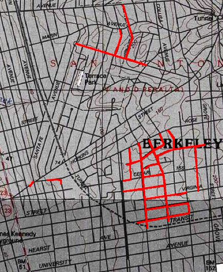
Last Christmas, I printed out a topographic map from a piece of software I have and traced out a map of the North Berkeley luminaria neighborhoods; I used different color inks to show the various years different blocks joined in. It’s not a presentation that translates to a digital format, so I’ve been thinking about how to do a map I could put online this year. There’s got to be something a semi-literate hack like myself can use to make a beautiful souvenir luminaria map; while I have faith that such a product exists, I haven’t found it yet. So back to the drawing board.

The map above is from the same software, Topo, that I used for my printouts last year. The streets that do the luminaria are traced in red using the software’s route tool. The big drawback to using the USGS maps for this purpose is that few streets are labeled. The resulting maps only make sense if you have an idea what you’re looking at to begin with.

My second option was to figure out how to present the luminaria using Google Maps. The maps are clear and easy to use and users can toggle back and forth between a regular street map and satellite pictures, or view a hybrid version. But making a Google Map from scratch using the available development tool would require more time to waste than even I have. So I decided to try to use an already-existing tool, the excellent Gmaps Pedometer, to trace out the luminaria street. As with the Topo versiion, that requires a lot of retracing to include every one of the contiguous blocks. But the result is pretty clear and you have the advantages of zooming in or out on the resulting map, and you have a very clear idea of what street is what. (Holly is in the northwest corner of the outlined luminaria streets). The biggest drawback is that the Pedometer doesn’t let you stop tracing in one spot and begin again in an unconnected spot. That means that I’ve left out several streets (shown in red on at the top of the Topo map above). This Gmaps tool also lacks any capacity (yet) for marking routes in different colors or for adding labels, so there’s no way of doing color-coding

So I’m playing with one more option: A site called MapBuilder.net that lets you build your own Google Map without recourse to any JavaScript or XML coding or access to a Web server to use the Google development resources. So what I came up with there is a Luminaria map (see if this link works: that highlights the chronology of the event (click on the arrow); and gives some idea of the geographic extent without showing all the streets involved. This is just a first try.

More later.

The Day After Graduation Day

It happened: Thom graduated from high school. That’s not the shocker. This is: When you hear people say things like, “Gee, it seems like just last week that we were taking him to the first day of pre-school,” believe them. It’s true. I saw our neighbor Asa today — he lived next door when we moved in in April 1988, and he’s still there. He and one of his roommates once baby-sat for Tom (then without the H). Their big adventure while Kate and I were out for the evening was changing his diaper. I know it happened a long time ago. But not that long ago, and now that kid is getting ready to pack up his stuff and move on. It’s what’s supposed to happen among us middle-class Americans and what does happen when all your hopes and work and planning and luck fit together right. Two boys out the door to next adventures. I can’t believe how quickly it all happened.

That’s all for now, I guess, except to say that for the most part I liked the event. It was crowded and wild. The Greek Theatre has an official capacity of 8,500, and the place looked like it was packed. It was as close to a true community celebration as Berkeley has — all the kids in public school go to Berkeley High (if they haven’t managed to get themselves sent to the “alternative” campus a few blocks away), and it seemed like all the families with seniors showed up. The crowd was raucous. The kids were often unruly. Most of the student speakers — and there were many — were sadly forgettable. In an exercise of hyper-democracy or gesture of anti-elitism, the program didn’t explain how any of the kids earned the distinction of a speech or say whether they were chosen by lottery. Still, I loved seeing so many of the kids I’ve known or heard about over the years going through the graduation line; and it was a great moment when the ceremony ended and the 680-some kids in the class just moshed together for about 15 or 20 minutes. It was one group of very happy-looking kids.