So Long, Ike; Next Up: Hurricane Nutjob

Ikenasa091208

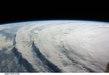
We continue with more exclusive coverage of the coverage of the aftermath of Hurricane Ike. The image above is the storm as it looked last Wednesday from the International Space Station, which was at an altitude of 220 miles. (For comparison’s sake, the GOES satellites that provide most of the views we see of Earth weather are parked in geosynchronous orbits with an altitude of 22,300 miles. The Terra and Aqua earth observatory satellites that regularly provide stunning images of wildfires and other events work at an altitude of about 430 miles.) NASA has posted a gallery of ISS shots of Ike. And if you like these ethereal views of killer storms, see a wonderful collection published last week on the Boston Globe’s The Big Picture blog.

Enough fawning over pictures. Now to the serious business at hand: If you think those photographs merely depict awesome natural forces at work, you’re sadly mistaken. No. Just like Katrina before it, those who see world weather as a giant conspiracy have declared that Hurricane Ike was a storm on behalf of (someone’s) scheme for global domination.

First, there’s this: An alert from Kevin Martin, a self-described meteorologist in Southern California, that “chemtrails” (a type of evil aircraft condensation trail) were detected last week in areas of the United States along Ike’s forecast path. Whoa. If you’re not sold on the forecaster’s credentials after reading that, check out his public plea for letters of recommendation so that he could be admitted Mississippi State’s online course for would-be TV weathercasters. (There’s more to Kevin’s story, too: one of his inspirations, it turns out, is that he was once struck by lightning.)

Then there’s this: Scott Stevens, formerly of Pocatello, Idaho, TV weatherman fame, announced before Ike’s landfall that “this entire storm is manufactured.” Scott, like Kevin, also saw dark doings overhead in the Midwest before the remnants of Ike got there. Faceless Global Dominators were manipulating weather to fill all the region’s rivers and streams before the moisture-laden ex-hurricane arrived. The motive behind the storm and associated “tweaking,” apparently, is economic chaos. As if we need any more help.

My one and only question to the World Weather Conspiracy folks would be: In olden times, before the advent of high technology–or maybe I should say human high technology, because the Faceless Dominators could be extraterrestrials or Greek or Norse gods unhappy in their retirement–who was responsible for all the floods, droughts, hail storms, heat waves, cold snaps and other weather catastrophes that beset us?

Technorati Tags: , , ,

Ike and the Stormettes

Storms

That’s a National Hurricane Center image of currently active tropical-type storms: Tropical Depression Gustav is parked over Texarkana. Out in the Caribbean and Atlantic, Tropical Storms Hanna, Ike, and Josephine (from west to east) are conga-lining toward the North America neighborhood. Those latter three storms are all expected to reach hurricane status before making landfall … somewhere.

Technorati Tags: ,

Gustav

Here’s what the National Hurricane Center has to say (public advisory and forecast discussion) about the storm melodramatically (and cross-dressingly) labeled “the mother of all storms” by the mayor of New Orleans. (How many people remember the origin of that “mother of” formulation? I think it’s time to retire the phrase and try some new personifying descriptions. A hurricane of Gustav’s reputation could be called anything from “unwelcome visitor” to “mannerless brute.” Any other suggestions? While we’re at it, we’d like also recommend a lifetime media ban on use of “The Big Easy” to describe New Orleans. If some hard-up news writers need a colorful handle for the city, let them use “The City that Care Forgot.”)

What’s it like down there in hurricane country? A blogger acquaintance I’ve followed for quite some time is named Rob. He lives near Bush, Louisiana, about 50 miles north of New Orleans. His blog is called Crabapple Lane, and he’s reporting on his preparations for the storm–including explaining why he’s choosing to ride it out at home rather evacuate. It’s compelling, immediate stuff. Thanks, Rob–we’re pulling for you.

Technorati Tags: , , ,

Contrails

Contrails062308

Snapped this while driving through downtown Spokane, Washington, at about 10 in the morning on June 23 with my friend Pete. You can count eight clearly visible contrails here, and the remains of possibly two more. I don’t know what accounts for the jet traffic over Spokane, though Seattle is in the direction most of these appeared to be headed. (I meant to post this ages ago, but am just getting around to it now because of a “thar’s strange things afoot in yonder sky”:comment made on a post elsewhere.)

Solstice and After

Well, I see I’ve missed our summer solstice by a day. It was too hot here to pay attention. Yesterday, the unofficial Holly Street high was 101–the hottest I’ve seen it since we moved in 20 years ago. The bonus: It stayed lovely and warm out all night, no sweatshirts needed. More of the same today. Just 9:30 in the morning, and it’s already in the 80s. One of the toughest bike rides in all of California, maybe the entire United States, is being held today: the Terrible Two. A series of precipitous climbs and descents through hot interior Sonoma County (mostly). My heart goes out to the 250 or 300 people who are out there; I’ve done daylong rides through heat like that, and for me it’s just something you have to survive.

And now: Running to Oakland airport to get on a plane to Spokane, Washington. My friend Pete is doing the Ironman Coeur d’Alene tomorrow, and I’m there as his official rooting section and post-event driver. Go Pete!

More from up north.

Technorati Tags: ,

Daily Planet

Watervapor

I happened to be looking at the local National Weather Service site the other day and started looking at the directory of satellite pictures. There’s nothing new about them — in my generation, we’ve been seeing something like this since we were kids. Since they’re familiar, it’s easy to overlook them, or to not really look at them. The beauty strikes me on several levels: the planet, the movement of weather, the fact we manage to put all the tools together to gather the images, make them available, and find ways to look beyond the visible images (as in the color enhanced water-vapor image above; somewhere in all the swirling moisture is a storm that’s supposed to arrive the day after tomorrow).

Technorati Tags:

Waiting for FROPA

Satsfcnps

Just after midnight, and it’s been raining since around noon. The forecast discussion has been saying all day that the rain will slacken after “the front” goes through, and all day long that moment — frontal passage, or FROPA in forecaster speak — has been predicted for about midnight.

What kind of front? Well, they’re hardly ever specific in the discussion; in that very cool map above — click for the larger versions — we’ve got a cold front depicted to the south and an occluded front passing over us. What’s an occluded front? This page at the University of Illinois shows a combination of fronts nearly identical to what we have over us right now.

Anyway, I just got back in from my late-night walk with The Dog, and it was just drizzling; we were out for about half an hour, and a few times the drizzle dwindled to nothing. Maybe that was FROPA

Technorati Tags: , ,

On the Bike: Weather Edition

Tomorrow’s event, part two of the qualifying series for this August’s Paris-Brest-Paris exercise in transatlantic self-punishment, is a 300-kilometer ride. That’s 188 miles in universally recognized American distance units. We’ll start at the Golden Gate Bridge at 6 a.m., ride up through the interior valleys of Sonoma County to the town of Healdsburg, head out along the Russian River to the townlet of Jenner, then ride down the coast highway to Point Reyes Station, where we’ll swing inland to go back to the bridge (the foregoing provided for those who want to keep score at home). Based on past experience, this will be something I’ll be doing well into the evening.

The hard part is: rain. The sky is clear out there now. But for the past two or three days, the forecast has predicted rain and, for the return trip on the coast, headwinds. I’ve been meaning to write a little something on the blessing and curse of modern weather forecasting for the modern bicycle rider. By which I mean: The blessing is that the sort of forecasting that’s possible today, along with tools like Doppler radar and satellite water-vapor imagery, can give you a pretty clear idea of what you’re riding into and when; the curse is that you become the prisoner of a prospective and freely revised reality.

Weather forecasting is highly model driven, meaning that a bunch of unimaginably fast and powerful computers are applying sophisticated mathematical models to the wealth of weather data pouring in from all over the globe; when the machines finish their model-assisted number crunching, they spit out a picture of the way the world will look in 12 and 24 and 48 hours and so on. Then forecasters take these visions of the world as the models predict it and try to turn them into forecasts. Except: Sometimes the forecasters are confronted with two or three or six conflicting, or at least significantly varying, takes on what tomorrow and the day after and the day after that, ad infinitum, will look like. Then the humans have to do something that is a cross between highly educated guesswork and astrology: often, based on observations about which models have “verified” recently, they’ll make a prediction based on a compromise reading of models or just lean on the model that seems the most trustworthy in a given set of circumstances.

The curse, more specifically, is that we can all look at the developing forecasts, read the forecasters’ reasoning, even consult the raw data if we think we can handle that. Which means, in the end, we don’t get a minute’s rest thinking about whether it will rain, how much it will rain, how awful the headwinds will be out on the road. On balance, it seems like it would be simpler, and much more peaceful for the soul, to just look out the window before you get on your bike. But that would be much too simple and would fail to make the best use of our high-speed Net connections.

Time for bed now, right after I check the forecast and the radar again.

Technorati Tags: , , , ,

Today’s Frost Report

Frost121806Frost121806A
Down to freezing again overnight (yes, I’m conscious that most of the vegetation on which the frost forms here is green, not Northern Hemisphere winter brown). Those little crystals of ice? They’re called spicules (according to the OED, which refers to them as spicula, a spicule is “1. A sharp-pointed or acicular crystal or similar formation … b. esp. A formation of this nature caused by the action of frost”).

Jack Frost Nipping at Your Ankles

Frost121706

Frost this morning, leading to today’s inquiry: How does frost form if the air temperature is above freezing? Frost is ice, after all, so where does it come from if your reasonably accurate thermometer (ours: on the back porch, six feet above the ground) shows that it’s 38 degrees outside? What accounts for car roofs getting frosted when there’s no other sign of frost in the area?

I never thought about this much growing up in Illinois because when you saw frost, it was usually well below freezing. Here, I started to wonder about it because wintertime frost is common in our relatively mild bayside climes, mostly when the thermometer is showing a temperature five or six degrees or more above freezing.

The short answer (from a couple of just-OK references, here and here) is that frost only forms (it sublimates, from water vapor directly to ice) in the presence of freezing temperatures. The temperature that’s critical in the process is not the air temperature several feet off the ground, where most thermometers are placed, but at the surface where frost is formed. Among the factors that make ground temperatures significantly colder than the air several feet above are radiative cooling–the process by which the ground is surrendering heat energy into the atmosphere in the absence of some input (sunlight, for instance)–and the tendency of cold air to sink. So while it’s 38 degrees at an altitude of six feet, it can be 32 or below on the ground; if there’s sufficient moisture in the air, frost will form.

And the presence of frost on car roofs, etc., when there’s little or no frost nearby? The same general explanation holds; the difference is that exposed metal and glass radiate heat faster and more completely than ground surfaces and thus reach the frost point more quickly. A car roof is an example of a sort of micro-micro-climate, I guess.

[Update, 12/19: I found a second thermometer and measured the temperature at the ground to compare it to the temperature recorded on our indoor-outdoor thermometer, which has a sensor at a height of six feet above the ground. The latter recorded a low this morning of 35 degrees; at the same time, the ground thermometer, which was just half an inch above the ground on one of those Frisbee donut things (so that air could circulate under it and so that it would not be resting directly on the ground), showed a temperature of 27 degrees.]

Frost121706A

Technorati Tags: ,